Gündlkofen
|
Gündlkofen
Municipality Bruckberg
Coordinates: 48 ° 31 '59 " N , 12 ° 1' 42" E
|
|
|---|---|
| Height : | 412 m above sea level NHN |
| Residents : | 870 (May 9, 2011) Source |
| Incorporation : | May 1, 1978 |
| Postal code : | 84079 |
| Area code : | 08765 |
|
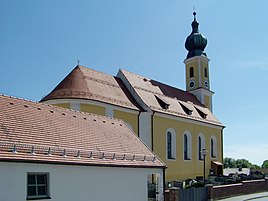
Parish church of St. Peter and Paul in Gündlkofen
|
|
Gündlkofen (until 1875 Gindlkofen ) is a parish village with around 900 inhabitants in Lower Bavaria and part of the municipality of Bruckberg . The village is about nine kilometers west of the city center of Landshut . Until 1978 Gündlkofen was a separate municipality with several districts, in whose area around 1,500 inhabitants live today (as of 2004).
location
The village is located on the northern edge of the Isar valley about three kilometers from the river and the adjacent Echinger reservoir . The settlement from the Gündlkofen railway station in the former Isar floodplains to the surrounding hills. In Gündlkofen, two side valleys meet the Isar valley, that of the Osterbach from the direction of Widdersdorf and the Holzgraben from the direction of Tondorf.
history
Gündlkofen was first mentioned in 880 . The altar wings of the high altar are still preserved from the former Romanesque church from the 14th century. The current rococo-style church was built between 1746 and 1756 according to plans by Landshut's master mason Johann Georg Hirschstötter and is consecrated to Saints Peter and Paul . The altar figures come from Christian Jorhan the Elder , who made them in 1790.
The municipality , founded in 1818 by the Bavarian municipal edict, comprised the towns of Gündlkofen, Antloh and Ried and had belonged to the Landshut district office since 1862 . In 1875 the name of the municipality was officially changed from Gindlkofen to Gündlkofen . On July 1, 1972, Tondorf was incorporated with the towns of Tondorf, Oberlenghart, Reith and Unterlenghart. On May 1, 1978, as part of the regional reform, the place came to the significantly enlarged municipality of Bruckberg (previously the district of Freising ), now in the administrative district of Lower Bavaria in the district of Landshut .
Population development
The population of the former community of Gündlkofen has risen continuously in recent decades due to strong influx. This is due to the proximity to the A 92 motorway , to the cities of Landshut and Munich and to the new Munich Airport in Erdinger Moos . While there were 246 inhabitants in 1900, their number has more than doubled to 503 by 1950, while the former community already had 1,016 inhabitants in 1993.
Infrastructure
The place has its own stop on the Munich – Regensburg railway line . Gündlkofen has a primary and middle school as well as a day care center, consisting of a kindergarten and a day nursery, each with all-day care. Gündlkofen is also connected to the Landshut bus network (line 9), and there is a bus connection to the grammar school in Furth for students.
Individual evidence
- ↑ a b Wilhelm Volkert (Ed.): Handbook of the Bavarian offices, communities and courts 1799–1980 . CH Beck, Munich 1983, ISBN 3-406-09669-7 , p. 508 .
- ^ Federal Statistical Office (ed.): Historical municipality directory for the Federal Republic of Germany. Name, border and key number changes in municipalities, counties and administrative districts from May 27, 1970 to December 31, 1982 . W. Kohlhammer GmbH, Stuttgart and Mainz 1983, ISBN 3-17-003263-1 , p. 616 .
- ^ Heimatpflegeverein Bruckberg eV: Gündlkofen ( Memento from March 4, 2016 in the Internet Archive ). Online at www.heimatpflegeverein-bruckberg.de. Retrieved January 3, 2016.
- ^ Schools in Bruckberg. Retrieved October 20, 2018 .
- ^ Day care centers in Bruckberg. Retrieved October 20, 2018 .
