
Si Thep Historical Park


The Historical Park Si Thep ( Thai อุทยาน ประวัติศาสตร์ ศรีเทพ , pronunciation: [ ʔùttʰáʔjaːn pràwàttìsàːt sǐ TEP ]) includes the ruins and foundations of the settlement Si Thep (also Sri Thep ; Sanskrit : Sri Deva , Thai: Mueang Si Thep ) from the Dvaravati - and Angkor -Time (5th to 13th centuries) in the northern region of Thailand . The facility has been on the tentative list for the UNESCO World Heritage Site since 2019 .
Location and description

The Historical Park Si Thep is located in the valley of the Pa Sak River (Pa Sak River) in the district ( Amphoe ) Si Thep of Phetchabun province , about 240 kilometers north of Bangkok .
During excavations , the remains of a historical settlement were uncovered. These consisted of two connected systems on an area of around 4.7 km². The western part was called the "inner city" (Mueang Nai) . It lies on an area of about 2.08 km², is almost circular and has a diameter of about 1.5 km. The city was surrounded by a wall with a moat in front of it. The historians suspect that in the city about 70 small ponds were distributed. In this part of the complex there are three structures : the Prang Si Thep, the Prang Song Phi Nong and the Khao Klang Nai Monument, as well as around 45 smaller archaeological objects.
On the eastern side of Mueang Nai, the “outer city” (Mueang Nok) was built on an area of around 2.54 km² . The terrain has a rectangular shape with rounded corners on the east side. Again the urban area was provided with a wall and moat. About 30 small pools of water and 54 archaeological objects were found. No structures have been preserved in this part of the complex. Looting and the use of stones for other restorations only left debris.
Outside the city area protected by walls (today's historical park) around 50 archaeological sites are maintained. Noteworthy is the Khao Khlang Nok Monument and the Prang Ruesi. Far away from these complexes is the Thamorat Cave.
history
The historical city of Si Thep was probably founded as early as the 5th century. According to archaeological evidence, the predominant religion in the city-state was Hinduism . However, a significant Buddhist influence is also documented. The sculptures found in Si Thep come closer to Indian models than those of all other sites from this period in Southeast Asia. This fact has led to the raising of the thesis that Si Thep was founded by Indian colonists.
The community was probably in close contact with the Mon city-states of the Dvaravati culture in what is now central Thailand as well as with Chenla , whose center was in what is now Cambodia, or the later empire of the Khmer . According to a theory of the historian Dhida Saraya ( ธิดา สาระ ยา ), which has not been proven so far and has been contested by other authors, Si Thep is identical to the capital Cānāśapura of the state Śri Canāśa , which is mentioned in an inscription in Mueang Sema . The art historian Hiram Woodward, who specializes in Southeast Asia, suggests a connection between Si Thep and the empire Wendan or "Land- Zhenla " described in Chinese sources .
The finds from Si Thep can be roughly divided into three phases. The first phase is called the “Indian”, the sculptures from the 5th to 7th centuries are very similar to their Indian models and show predominantly Hindu motifs. The British orientalist HG Quaritch Wales (1900-1983) suspected that Si Thep belonged to Funan's sphere of influence at this time . This is followed by an era from the 7th or 8th to the 11th century, in which the art shows great resemblance to the Dvaravatis. Most of the Buddhist finds are assigned to this period, but Hindu art continued to be created at the same time. Around the 11th century, Si Thep was incorporated into the Hindu Khmer Empire of Angkor , in which it served as an important center until the 13th century. The city was later abandoned and left to the jungle.
Discovery and history of research
In 1904 the amateur historian Prince Damrong Rajanubhab discovered entries in the records of Ayutthaya and Rattanakosin about a historical city named Si Thep . His inquiries were unsuccessful, nobody knew this city. Through his research, he came to the conclusion that Si Thep must be between Mueang Chai Badan and Mueang Phetchabun . In 1905 he made an official trip to what was then Monthon Phitsanulok. Eventually he found a ruined city , but it was called Mueang Aphai Sali by the villagers and seemed much older than the one Prince Damrong was hoping to find. Talks with government officials in nearby Wichian Buri confirmed his suspicion. He learned that Wichian Buri was previously called Si Thep . He believed that the city he was looking for was on the site of Wichian Buri. However, he did not find any archaeological evidence. The prince heard that in the city as Wichian Buri was still named as Si Thep , a governor with the title Phra Si Thamorat was in office. The name had a connection to Mount Khao Tha Mo Rat which is near the ruined city. The prince was certain that the ruined city found was the historical city of Si Thep he was looking for.
After the rediscovery in 1905 by Prince Damrong Rajanubhab, large-scale excavations were only carried out in 1935 by HG Quaritch Wales. He was able to reconstruct the oval ground plan of the city with city walls and moats. Several gates led into the city, which contained five temples with terraces and pools. In addition to numerous sculptures from the Dvaravati period, several statues of the Hindu gods Vishnu , Krishna and Surya were found during the excavations , which are now in the Bangkok National Museum . Sculptures carved into the walls were found in a cave in (mountain) Khao Tha Mo Rat.
The Si Thep site poses numerous questions and puzzles to archaeologists, historians and art historians. Various theories about her are sometimes controversial. It is questionable, among other things, why an apparently so important city is so remote from the remains of other settlements from the same period, to which political unit it belonged, to which ethnic group its inhabitants belonged and how the evidence of Hindu and Buddhist art fit together.
A clear division into Buddhist Dvaravati style and Hindu Khmer style cannot be made. The Hindu representations in Si Thep are influenced by a synthesis of Khmer, Dvaravati, and Srivijaya styles (although Dvaravati and Srivijaya were actually Buddhist). On the other hand, there are also Buddha statues that follow this mix of styles, which was initially considered typical of the Hindu art of Si Theps, and even bodhisattva representations that mostly follow the (actually Hindu) Khmer style.
Attractions
In the Mueang Nai:
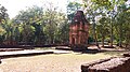
Prang Si Thep

The Prang Si Thep has a square floor plan. The tower is made of bricks and was built on a laterite base about 1 meter high . It was decorated with a lotus-shaped top made of sandstone, which has fallen off. There is an entrance on the west side. The entrances on the other sides were mock-ups. The tower was originally a Hindu sanctuary, which was adapted to the Mahayana Buddhist cult at the time of King Jayavarman VII . This can be seen in the decoration of two found lintels. Further traces are an unfinished antefix . The work was apparently stopped before the city was abandoned. The tower was built around the 11th to 12th centuries.
Prang Song Phi Nong

The Prang Song Phi Nong consists of two towers. One big and one small. The name in Thai means: Prang = tower, Song = 2, Phi = big brother or big sister, Nong = little brother or little sister. The towers were built in the Khmer era, in the 12th century.
Both brick towers stand on the same laterite pedestal about 1 meter high. The west-facing Phi Tower is about 7 meters high. It consists of a square room in which a holy figure once stood. The walls have triangular niches in which candles or religious statues have been placed. To the south of the Phi Tower is the Nong Tower. This tower was almost completely destroyed except for the foundation walls. Using existing building materials and the only lintel found undamaged, the Department of Fine Arts of Thailand reconstructed Nong Tower to its present form.
Khao Klang Nai

The Khao Klang Nai Monument faces east. It has a rectangular shape with approximately the following dimensions: length 44.5 meters, width 28.5 meters. Height 12 meters. It is made of laterite . Khao Klang Nai is assigned to the Dvaravati era as a Buddhist stupa . Any structures or decorations on this monument are hardly recognizable. Only on the west side you can see that the base area was covered with mortar . Various stucco work still exists here. The depicted monkeys, lions, elephants, buffalo and ganas dwarfs are caryatids or atlases that protect or support the monument. According to their style, the time of origin is placed in the 6th or 7th century.
Prehistoric burial place

It was not until excavations in 1988 that five skeletons were found at a depth of 4 meters. A female skeleton was completely preserved. It lies on its back and faces north. She wears a carnelian chain around her neck, a bronze bracelet around her left elbow, and an iron tool in her left hand . Earthen beads have also been found. Radiocarbon AMS dating of a human canine revealed an age of approximately 1,700 years. The grave goods show that the area was inhabited long before the rise of the city of Si Thep.
Park Museum

Statues of the Hindu sun goddess Surya, Buddhist dharmachakras and other excavated objects are displayed in the park museum . These are mostly copies, the originals are in the National Museum in Bangkok.
Outside the park:
Khao Khlang Nok

The Khao Khlang Nok Monument is located about 2 km northwest of the Mueang Nai near (village) Ban Sra Prue. The square laterite base of an impressive 64 meters and a height of 20 meters remains from the former ruler's grave. A hemispherical stupa was built in the middle of the plateau . The architectural style is assigned to Dvaravati Buddhism. The monument was erected around the 8th to 9th centuries.
Prang Ruesi

The Prang Ruesi is located about 2 km northeast of the Mueang Nai in the area of the (temple) Wat Pa Sra Kaew. The tower is made of bricks and laterite. It was built at the time of the Khmer, around the 11th century. It has been changed several times in the course of its history. The last time was in 2009. Next to Prang Ruesi there was a smaller tower and other buildings, of which only remnants are left.
Thamorat cave
The Thamorat Cave is about 25 km to the west of the Mueang Nai. The cave entrance is located near the summit of Khao Tha Mo Rat (560 m above sea level) (at 502 m above sea level). With a local guide, the 1,500-meter route to the cave entrance should take about an hour. The path is very steep, slippery and only recommended for experienced mountaineers.
Various Buddhist Mahayana , Buddha and Bodhisattva figures, stupas and Dharmachakras can be seen in stone carvings in the cave . The Buddha figures were once stripped of their heads, but these were brought back. Since then, the originals have been resting in the National Museum in Bangkok. Copies of the heads were made and are exhibited in the Museum of the Historical Park.
Impressions from the historical park

Prang Si Thep

Prang Si Thep

Prang Song Phi Nong

Lintel of the Prang Nong

Khao Khlang Nai

Stucco, Gana's dwarf on the base of Khao Khlang Nai

Weather protection for the stucks on Khao Khlang Nai

Dharmachakra ("wheel of law"), at Khao Khlang Nai

Khao Khlang Nok

Khao Khlang Nok

Prang Ruesi, before the renovation in 2009
Prang Ruesi, after the renovation in 2009
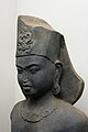
Surya statue in the Park Museum (copy, original in the National Museum Bangkok)
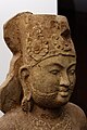
Surya statue in the Park Museum, (copy, original in the National Museum Bangkok)


conservation
On February 25, 2019, it was announced that two of the largest oil drilling companies in Thailand wanted to expand their search for oil near Si Thep. The plan was to build a derrick just 100 meters from the Khao Khlang Nok monument. Resistance to this project immediately formed in the population, the academic community and the cultural sector. In the districts (Amphoe) Si Thep and Wichian Buri 95 drilling rigs are already in operation. There are repeated reports of environmental damage and corresponding protests by the population.
The construction of this derrick cannot be prevented by the Fine Arts Department due to a lack of legal authorization. The drilling companies must submit an environmental impact report to the Office for Raw Materials, Environmental Policy and Planning (ONEP) for approval.
On March 11, 2019, General Director Anandha Chuchoti from the Fine Arts Department informed that the drilling companies had stopped the project. It is now planned to expand the Si Thep Historical Park and set up a buffer zone so that the archaeological sites can be better protected. Preparations are underway to register the ruined city of Si Thep as a World Heritage Site.
On April 11, 2019, the National Committee of Thailand for the World Heritage Convention submitted its request to UNESCO to include the Si Thep Historical Park as a World Heritage Site . As of June 30, 2019, UNESCO put the Si Thep Historical Park on its "preliminary list" of World Heritage Sites. Thailand is requested to submit additional documents showing the outstanding universal value of the cultural sites.
literature
- Robert L. Brown: The Dvāravatī Wheels of the Law and the Indianization of South East Asia. Brill, Leiden 1996, ISBN 90-04-10435-6 .
- Pisit Charoenwongsa, MC Subhadradis Diskul : Thailand . Wilhelm Heyne Verlag, Munich 1978, ISBN 3-453-35022-7 , ( Archaeologia Mundi 22).
- Peter Skilling: L'énigme de Si Thep. In Pierre Baptiste, Thierry Zéphir (ed.): Dvāravatī. Aux sources du bouddhisme en Thaïlande. Exhibition catalog, Réunion des Musées nationaux, Paris 2009, pp. 117–125.
- HG Quaritch Wales : Dvâravatî. The Earliest Kingdom of Siam (6th to 11th Century AD) . Quaritch, London 1969, ISBN 0-85388-002-6 .
- Hiram Woodward: Dvāravatī, Si Thep and Wendan. In: Bulletin of the Indo-Pacific Prehistory Association , Volume 30, 2010, pp. 87-97.
- Information brochure for park visitors: Si Thep Historical Park (English), by the Department of Fine Arte, Ministry of Culture
Web links
- Tripadvisor: Sri Thep Historical Park (All photos 83 pictures from the park, unfortunately no description). Retrieved December 4, 2019
Individual evidence
- ↑ a b Bangkok Post (online): Two sites placed on Unesco 'tentative list' . Report of July 9, 2019. Accessed December 4, 2019
- ↑ a b c d e f g h Park documentation: Si Thep Historical Park Phetchabun Province, Thailand. The 4th Regional office of Fine Arts, Department of Fine Arts, Ministry of Culture (English)
- ↑ Stanislaw Czuma: Mon-Dvaravati Buddha. In: Bulletin of the Cleveland Museum of Art , September 1980, p. 235, quoted in Brown: The Dvāravatī Wheels of the Law. 1996, p. 33.
-
↑ Dhida Saraya: Si Thep khue Si Chanasa. [Si Thep was Sricanasa.] In: Muang Boran Journal Volume 11, No. 1, 1985, pp. 63-76. [Thai with abstract in English]. Quoted from Nicolas Revire: Pierre Dupont's L'archéologie mône de Dvāravatī and Its English Translation by Joyanto K. Sen, In Relation with Continuing Research. In: Journal of the Siam Society , Volume 99, 2011, p. 204.
Dhida Saraya: (Sri) Dvaravati. The Initial Phase of Siam's History. Muang Boran Publishing, Bangkok 1999. - ^ Dougald JW O'Reilly: Early Civilizations of Southeast Asia. AltaMira Press, Lanham MD / Plymouth 2007, p. 82.
- ↑ Woodward: Dvāravatī, Si Thep and Wendan. 2010.
- ^ Brown: The Dvāravatī Wheels of the Law. 1996, p. 34.
- ↑ Revire: Pierre Dupont's L'archéologie Mone de Dvaravati. 2011, p. 204.
- ^ Brown: The Dvāravatī Wheels of the Law. 1996, p. 33.
- ^ Brown: The Dvāravatī Wheels of the Law. 1996, p. 35.
- ^ Thailand Tourism Directory: Prang Sri Thep . Retrieved December 4, 2019
- ↑ Tourism Thailand: Si Thep Historical Park (English). Retrieved November 30, 2019
- ^ Museum Thailand: Si Thep Historical Park (English). Retrieved December 4, 2019
- ↑ New Mandala: Will oil hunters destroy Thailand's biggest ancient city? . Report by Phacharaphorn Phanomvan, February 28, 2019 (English). Retrieved December 4, 2019
- ^ The Nation Thailand: New measures to protect Phetchabun historical park . Report of March 11, 2019 (English). Retrieved December 4, 2019
Coordinates: 15 ° 27 '59.7 " N , 101 ° 9' 0.3" E