Geuser
|
Geuser
City of Wallenfels
|
|
|---|---|
| Coordinates: 50 ° 14 ′ 38 ″ N , 11 ° 28 ′ 9 ″ E | |
| Height : | 601 (595-605) m above sea level NHN |
| Incorporation : | July 1, 1972 |
| Postal code : | 96346 |
| Area code : | 09262 |
|
Geuser
|
|
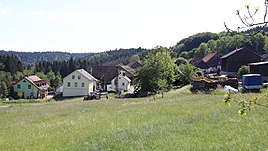
Geuser is a district of the town of Wallenfels in the Upper Franconian district of Kronach in Bavaria .
geography
In the former municipality is 600 m north of the Geuserberg , at 708 m above sea level. NN one of the highest elevations in the Franconian Forest . The Zeyern , a left tributary of the Rodach, rises 150 m south of the town center .
history
Geuser was a clustered village characterized exclusively by agriculture and forestry . The Bavarian original cadastre recorded eleven farmsteads there in the 1810s.
There were no industrial or handicraft businesses. The community Geuser consisted of the places Geuser, Dörnach, Forstloh and Haid. With the regional reform in Bavaria in the 1970s, Geuser was incorporated into the city of Wallenfels .
traffic
Geuser is accessible through the district road KC 31 running east of the village to the federal road 173 in the north and the KU 24 in the south.
Attractions
A stable house from 1849 as well as three wayside crosses and wayside shrines have been preserved as architectural monuments . A wayside cross from 1940 on the way to Zeyern and the small chapel in the center of the village, which was built in 1953, are also under monument protection .
Eight architectural monuments are listed for Geuser in the Bavarian list of monuments.


