Gladbach (Niers)
| Gladbach | ||
| Data | ||
| Water code | DE : 28614 | |
| location | Mönchengladbach , North Rhine-Westphalia , Germany | |
| River system | Rhine | |
| Drain over | Niers → Maas → Hollands Diep → North Sea | |
| River basin district | Meuse | |
| muzzle | In the east of Mönchengladbach in the Niers coordinates: 51 ° 11 '57 " N , 6 ° 29' 38" E 51 ° 11 '57 " N , 6 ° 29' 38" E |
|
| Mouth height |
45 m above sea level NN
|
|
| length | 1.9 km | |
| Catchment area | 26.208 km² | |
| Much of it runs underground | ||
The Gladbach is a brook in Mönchengladbach and one of the namesake of the city. It represents a flowing water (water code number 28614) in the sub-catchment area of the Niers . The Gladbach rises in the west of the city (the source is today in the basement of the building of the reopened Hensen brewery in Mönchengladbach-Waldhausen) and flows into the Niers in the east of the city.
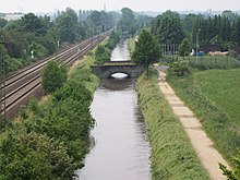
Today the Gladbach initially runs underground within the NEW AG sewer network . This canal was created around 1900. The length of the canal is around 4400 meters. From about two kilometers before the confluence with the Niers, it runs above ground as an open channel. In this part of the river , coming from the Volksgarten from the south , the Bungtbach, which used to be largely canalized, flows into it, the open channel of which has been completely renatured. To this end, NEW invested 3.4 million euros for retention between 2010 and mid-2014 in the creation of wet forest areas and wet grasslands along the Bungtbach, which can absorb up to 50,000 m³ of flooding in heavy rain. An underground rainwater clarification basin was built on Hardterbroicher Straße, as the Bungtbach no longer has any sources and is now fed exclusively from discharged rainwater.
Historical course
The Gladbach ran through Mönchengladbach from west to east. From the source in Waldhausen, first along Roermonder Straße / Waldhausener Straße into the large pond (only a small part of it, the Geroweiher, has survived today). For this the Gladbach flowed beneath the pond gate at the Supreme mill pass along the road to Lüpertzender Flieschermühle and on to Vitgesmühle at Berliner Platz. Then continue following the course of Lüpertzender Straße via today's Rathenaustraße to Krallsmühle on Erzberger Straße (roughly between Lürriper Straße and Korschenbroicher Straße). From there the Gladbach flowed south of Lürriper Straße to Rohrplatz. The tube mill was located there . Then continue following Rohrstrasse in a north-easterly direction, first past the Gierthmühle and the Compesmühle . Then roughly following the course of Habichtstrasse to the Lürrip sewage treatment plant (from approx. 1904) on the Hülserkamp street. After that, the Gladbach flowed west parallel to the Niers in a northerly direction to the Engelsmühle , before flowing into the Niers behind the mill at the Abtshof. Since 1937, the Gladbach in the Lürrip area, from just before the former Gierthmühle, where it comes to the surface again, has been canalized and flows along the Mönchengladbach-Neuss railway line to the confluence with the Niers.
The course mentioned above can only be approximated due to the current buildings and streets. The current street names are mentioned. At places where the (now underground) Gladbach crosses major roads, it is marked by signs.
Gladbach Canal
The Gladbach as such no longer exists in the urban area. However, there is the so-called Gladbach Canal, which, as the main rainwater collector, forms the receiving water for the rainwater drainage in Alt-Mönchengladbach. In addition to the catchment area of the Bungtbach, this sewer takes over a large part of the old rain overflows from the mixed water sewer system . As a result, it is particularly heavily contaminated with suspended solids containing PCBs .
To improve the water quality of Bungtbach and Gladbach, the city of Mönchengladbach has invested around 100 million euros in the " mixed water discharge collector" construction project since 1999 . The ratio of separate sewer to mixed water sewer in Mönchengladbach (2006) is about 2/3 to 1/3.
literature
- Robert Lünendonk: On the trail of the Gladbach and its mills . 1st edition, Klartext-Verlagsges., 144 S., Essen 2008, ISBN 3-8375-0030-6
- Robert Lünendonk: Brooks and Mills in Mönchengladbach 1st edition 2015 ISBN 978-3-8375-1569-5
Individual evidence
- ^ German basic map 1: 5000
- ↑ a b Topographical Information Management, Cologne District Government, Department GEObasis NRW
- ↑ Hans Vogt: Lower Rhine water mill guide . Ed .: Verein Niederrhein eV Krefeld 1998, ISBN 3-00-002906-0 , Gladbach, p. 497 .
- ^ Report on RP-Online
- ^ Plan of renaturation at MG-HEUTE


