
Vitgesmühle
| Vitgesmühle
|
||
|---|---|---|
 The Vitgesmühle on the original cadastral map |
||
| Location and history | ||
|
||
| Coordinates | 51 ° 11 '32 " N , 6 ° 26' 23" E | |
| Location |
|
|
| Waters | Gladbach | |
| Built | First mentioned in 1183 | |
| Shut down | 1886 demolished | |
| technology | ||
| use | Flour mill | |
| Grinder | 1 grind | |
| drive | 1 water wheel | |
| water wheel | overshot | |

The Vitgesmühle was a water mill with an overshot water wheel on the Gladbach in the city of Mönchengladbach .
geography
The Vitgesmühle was located on the left side of the Gladbach, at today's intersection between Lüpertzender Straße and Berliner Platz. In front of the mill was a mill pond on the right side of the Gladbach. The Flieschermühle was located above, the Krallsmühle below . The area on which the mill building stood has a height of approx. 55 m above sea level .
Waters
The Gladbach, (GEWKZ 28614), which is also the namesake of the city of Mönchengladbach, has been an important lifeline for centuries. It supplied the residents and a total of eight mills with water and was the origin of the flourishing textile industry in Mönchengladbach. The approximately 6.3 km long Gladbach rises in Waldhausen , crossed the districts of Pesch and Lürrip and flowed into the Niers at Uedding . Today it is mostly piped and flows from Volksbadstrasse at 1,904 m as an open channel along the Mönchengladbach – Düsseldorf railway line to the Niers. The catchment area of the body of water is 26.208 km 2 . The care and maintenance of the water is incumbent on NEW AG .
history
The Vitgesmühle was first mentioned in a document in 1183, when Abbot Walter II (1183–1190) acquired the mill and donated the proceeds to the monks' convent . It is the oldest documented mill in Mönchengladbach. The mill was also called Untere Mühle , Lingenmühle and Wolfkensmühle in the course of time . In the period around 1682/84, the then abbot Ambrosius Steingens had to leave the barn belonging to the Vitgesmühle to the Reformed for their services . This happened on the orders of the state and against the will of the abbot. With the secularization , the overshot mill came into private ownership. In 1886 the mill was stopped. The mill was demolished to make way for the imperial bath . Most of the grinding equipment was sold to Gierthmühle .
gallery

Former location of the Vitgesmühle
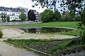
Former location of the Vitgesmühle mill pond
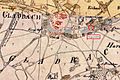
The Vitgesmühle on the Tranchot map 1803–1820

The Gladbach as an open channel
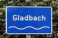
Signs show the course of the Gladbach canal

The Gladbach flows into the Niers


literature
- Hans Vogt: Lower Rhine water mill guide , 2nd edition. Niederrhein Association, Krefeld 1998, ISBN 3-00-002906-0 , pp. 499-500.
- Robert Lünendonk: On the trail of the Gladbach and its mills . 2008, ISBN 3-8375-0030-6 , 1st edition, p. 59.
- Robert Lünendonk: The Niers and their mills . 2012, ISBN 978-3-8375-0741-6 , pp. 66-70.
Web links
Individual evidence
- ^ German basic map 1: 5000
- ↑ http://www.lanuv.nrw.de/fileadmin/lanuv/wasser/pdf/Gewaesserverzeichnis%20GSK3C.xls
Am Mühlenbach :
Vollmühle
Am Gladbach :
Compesmühle |
Angel Mill |
Tile mill |
Yaw mill |
Krallsmühle |
Supreme Mill |
Tube mill |
Vitgesmühle
An der Niers :
Bellermühle |
Bottmühle Odenkirchen |
Broichmühle |
Burgmühle Odenkirchen |
Eickesmühle |
Güdderather Mühle |
Kappelsmühle |
Nun mill |
Odenkirchen paper mill |
Wickrath paper mill |
Pixmühle |
Pletschmühle |
Wetscheweller mill |
Wickrathberger Mill |
Wilderather Mill |
Rheydt Castle Mill |
Castle mill Wickrath |
Schwalmer Mill |
Stone mill |
Zoppenbroich Mill