
Wickrathberger Mill
| Wickrathberger Mill
|
||
|---|---|---|
 The Wickrathberger Mühle |
||
| Location and history | ||
|
||
| Coordinates | 51 ° 6 '49 " N , 6 ° 24' 39" E | |
| Location |
|
|
| Waters | Niers | |
| Built | 1720 | |
| Shut down | 1952 | |
| technology | ||
| use | Oil and grain mill | |
| Grinder | 3 grinding courses | |
| drive | 1 water wheel , from 1900 Francis turbine , from 1945 electric drive | |
| water wheel | undershot | |

The Wickrathberger Mühle was a water mill with an undershot water wheel on the upper reaches of the Niers in the Mönchengladbach district of Wickrathberg in the administrative district of Düsseldorf .
geography
The Wickrathberger Mühle is located on the right side of the Niers, at Niersstrasse 31, in the Mönchengladbach district of Wickrathberg. Above was the Kappelsmühle , below the Wickrath Castle Mill . The area on which the mill building stands is at a height of approx. 63 m above sea level .
Waters
The Niers (GEWKZ) 286 in its old river bed supplied numerous mills with water for centuries until the river was straightened . The Niers rises in Kuckum , a district of the city of Erkelenz . The Niers has a total length of 117.668 km and a total catchment area of 1,380.630 km 2 up to its confluence with the Meuse near Gennep (Netherlands) . The source is 73 m above sea level. NN , the mouth at 9 m above sea level. NN . The Niersverband is responsible for the care and maintenance of the water .
history
The Wickrathberger Mühle, which was also called Berger Mühle, was built in 1720 as an oil mill . The stately mill building belonged to the Lords of Quadt on Wickrath . The mill was later converted into a flour mill with four grinding courses and operated at times as a ban mill. In 1812 the mill went into private ownership. A Francis turbine was installed around 1900 . The mill was severely damaged in bombing raids in 1943 and the Niers Bridge was blown up in 1945, but it was able to resume operation with an electric motor . In 1952 the mill was stopped. The mill building now serves as a residential building.
gallery

The house

The course of the Niers near the mill

Niersbrücke near the mill

Courtyard view

Millstones decorate the courtyard

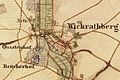
Wickrathberg on the new map from 1912
The location of Wickrathberg on the original cadastral map from 1846

Wickrathberg on the Tranchot map 1803–1820
.jpg)


Monument entry
Former watermill in Wickrathberg, entry as a memorial on December 4, 1984
The property at Niersstraße 31 is located in the Wickrathberg district in the form of a closed courtyard near the Niers. The baroque house is built on two floors in brick with a gable roof. The commercial access is provided with a round arch, left and right four windows. Year of construction 17th - 18th century. Ten window axes along the street on the 1st floor.
literature
- Hans Vogt: Lower Rhine water mill guide 2nd edition. Niederrhein Association, Krefeld 1998, ISBN 3-00-002906-0 , page 480.
- Robert Lünendonk: The Niers and their mills 1st edition November 2012, ISBN 978-3-8375-0741-6 , pages 32-35, 84-85.
Web links
- Fishing on the Niers
- Interesting facts about the Niers
- Former watermill in Wickrathberg
- Website about Wickrathberg
Individual evidence
- ^ German basic map 1: 5000
- ↑ http://www.lanuv.nrw.de/fileadmin/lanuv/wasser/pdf/Gewaesserverzeichnis%20GSK3C.xls
- ↑ Archived copy ( memento of the original from October 17, 2013 in the Internet Archive ) Info: The archive link was inserted automatically and has not yet been checked. Please check the original and archive link according to the instructions and then remove this notice.
- ↑ http://www.Niersverband.de/
Am Mühlenbach :
Vollmühle
Am Gladbach :
Compesmühle |
Angel Mill |
Tile mill |
Yaw mill |
Krallsmühle |
Supreme Mill |
Tube mill |
Vitgesmühle
An der Niers :
Bellermühle |
Bottmühle Odenkirchen |
Broichmühle |
Burgmühle Odenkirchen |
Eickesmühle |
Güdderather Mühle |
Kappelsmühle |
Nun mill |
Odenkirchen paper mill |
Wickrath paper mill |
Pixmühle |
Pletschmühle |
Wetscheweller mill |
Wickrathberger Mill |
Wilderather Mill |
Rheydt Castle Mill |
Castle mill Wickrath |
Schwalmer Mill |
Stone mill |
Zoppenbroich Mill