
Wetscheweller mill
| Wetscheweller mill
|
||
|---|---|---|
 Former location of the Wetscheweller mill |
||
| Location and history | ||
|
||
| Coordinates | 51 ° 7 '55 " N , 6 ° 25' 36" E | |
| Location |
|
|
| Waters | Niers | |
| Built | 1483 first mentioned in a document | |
| Shut down | 1878/80 | |
| technology | ||
| use | Oil and grain mill | |
| Grinder | 2 grinding courses 1 oil press | |
| drive | 1 water wheel | |
| water wheel | undershot | |

The Wetscheweller Mill was a water mill with an undershot water wheel at the upper reaches of the Niers in Mönchengladbach District Wickrath in the administrative district of Dusseldorf .
geography
The Wetscheweller Mühle was located on the right side of the Niers, on Odenkirchener Straße, in the Mönchengladbach district of Wickrath. Above was the Wickrath paper mill , below the Güdderath mill . The area on which the mill building stands is at a height of approx. 62 m above sea level .
Waters
The Niers (GEWKZ 286) in its old river bed supplied numerous mills with water for centuries until the river was straightened . The Niers rises in Kuckum , a district of the city of Erkelenz . The Niers has a total length of 117.668 km and a total catchment area of 1,380.630 km 2 up to its confluence with the Meuse near Gennep (Netherlands) . The source is 73 m above sea level. NN , the mouth at 9 m above sea level. NN . The Niersverband is responsible for the care and maintenance of the water .
history
Between the districts of Wickrath and Odenkirchen was the old Honschaft Wetschewell, which was cut by the border of the rulership . On the Wickrath side was the Wetscheweller mill, which belonged to Wickrath Castle . In 1483 the mill was first mentioned as oelichsmolen (oil mill). In later times were two millstones for grain added, which could be used alternately. The name of the mill also changed due to a change of tenants and owners. The name Sommers Mühle is known from around 1782, and around 1830 the mill was named Klammermühle . Milling was stopped between 1878 and 1880. The mill became a coffee roastery , which was rebuilt and continued to operate even after the war was destroyed. The mill jam was removed in 1951/52 during the Niersregulierung. Today there is a residential and commercial building on the former site of the mill.
gallery

The course of the Niers in Wetschewell

Sign for the Niersuferweg
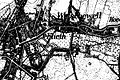
Wetschewell on the map new entry from 1912

The location Wetschewell on the original cadastral map from 1846

The Honschaft Wetschewell on the tranchot card 1803-1820


literature
- Hans Vogt: Lower Rhine water mill guide 2nd edition. Verein Niederrhein, Krefeld 1998, ISBN 3-00-002906-0 , page 483.
- Robert Lünendonk: The Niers and their mills 1st edition November 2012, ISBN 978-3-8375-0741-6 , pages 40–41, 89–91.
Web links
Individual evidence
- ^ German basic map 1: 5000
- ↑ http://www.lanuv.nrw.de/fileadmin/lanuv/wasser/pdf/Gewaesserverzeichnis%20GSK3C.xls
- ↑ Archived copy ( memento of the original from October 17, 2013 in the Internet Archive ) Info: The archive link was inserted automatically and has not yet been checked. Please check the original and archive link according to the instructions and then remove this notice.
- ↑ http://www.Niersverband.de/
Am Mühlenbach :
Vollmühle
Am Gladbach :
Compesmühle |
Angel Mill |
Tile mill |
Yaw mill |
Krallsmühle |
Supreme Mill |
Tube mill |
Vitgesmühle
An der Niers :
Bellermühle |
Bottmühle Odenkirchen |
Broichmühle |
Burgmühle Odenkirchen |
Eickesmühle |
Güdderather Mühle |
Kappelsmühle |
Nun mill |
Odenkirchen paper mill |
Wickrath paper mill |
Pixmühle |
Pletschmühle |
Wetscheweller mill |
Wickrathberger Mill |
Wilderather Mill |
Rheydt Castle Mill |
Castle mill Wickrath |
Schwalmer Mill |
Stone mill |
Zoppenbroich Mill