
Castle mill Odenkirchen
| Castle mill Odenkirchen
|
||
|---|---|---|
 Bronze plaque of the Burgmühle Odenkirchen |
||
| Location and history | ||
|
||
| Coordinates | 51 ° 8 '9 " N , 6 ° 27' 3" E | |
| Location |
|
|
| Waters | Niers | |
| Built | First mentioned in 1373 | |
| Shut down | 1958 | |
| technology | ||
| use | Grain and oil mill | |
| Grinder | 1 grind 1 oil press | |
| drive | Water wheel , turbine , electric drive | |
| water wheel | undershot | |

The Burgmühle Odenkirchen was a water mill with an undershot water wheel on the upper reaches of the Niers in the Mönchengladbach district of Odenkirchen in the administrative district of Düsseldorf .
geography
The Burgmühle Odenkirchen was located on the right side of the Niers, Zur Burgmühle 46, in the Mönchengladbach district of Odenkirchen. Above was the Güdderath mill , below the Bottmühle Odenkirchen . The area on which the mill building stands is at a height of approx. 55 m above sea level .
Waters
The Niers (GEWKZ 286) in its old river bed supplied numerous mills with water for centuries until the river was straightened . The Niers rises in Kuckum , a district of the city of Erkelenz . The Niers has a total length of 117.668 km and a total catchment area of 1,380.630 km 2 up to its confluence with the Meuse near Gennep (Netherlands) . The source is 73 m above sea level. NN , the mouth at 9 m above sea level. NN . The Niersverband is responsible for the care and maintenance of the water .
history
The mill, first mentioned in 1373, was part of Odenkirchen Castle . It belonged to the rule of Odenkirchen and was at the same time a ban mill for all residents. The under-powered mill was a grain and oil mill . In 1689 the mill was destroyed in the bombardment of Louis XIV during a war . In 1701 the mill burned down and was renovated in stone. In the course of secularization , the mill came into private ownership and was converted into a cotton mill. After another change of ownership in 1889, the mill was modernized. A turbine and a little later an electric drive were put into operation. In 1958 the economic pressure on the large mills was so strong that the oldest mill in Odenkirchen was shut down. To commemorate the castle mill and other mills Odenkirchens one was monument with bronze plaques erected.

The castle mill Odenkirchen in 1963

The Odenkirchener mills on the Niers

Mill monument at the location of the castle mill

Street name Zur Burgmühle

Niers and mill monument
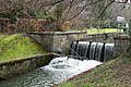
Weir at the Burgmühle
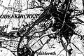
Odenkirchen on the map new entry from 1912

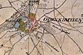
The location of Odenkirchen on the original cadastral map from 1846
Odenkirchen on the Tranchot map 1803–1820


literature
- Hans Vogt: Lower Rhine water mill guide 2nd edition. Verein Niederrhein, Krefeld 1998, ISBN 3-00-002906-0 , pages 485-487.
- Robert Lünendonk: Die Niers and their mills 1st edition November 2012, ISBN 978-3-8375-0741-6 , pages 41–43, 92–94.
Web links
Individual evidence
- ^ German basic map 1: 5000
- ↑ http://www.lanuv.nrw.de/fileadmin/lanuv/wasser/pdf/Gewaesserverzeichnis%20GSK3C.xls
- ↑ Archive link ( Memento of the original from October 17, 2013 in the Internet Archive ) Info: The archive link was inserted automatically and has not yet been checked. Please check the original and archive link according to the instructions and then remove this notice.
- ↑ http://www.Niersverband.de/
Am Mühlenbach :
Vollmühle
Am Gladbach :
Compesmühle |
Angel Mill |
Tile mill |
Yaw mill |
Krallsmühle |
Supreme Mill |
Tube mill |
Vitgesmühle
An der Niers :
Bellermühle |
Bottmühle Odenkirchen |
Broichmühle |
Burgmühle Odenkirchen |
Eickesmühle |
Güdderather Mühle |
Kappelsmühle |
Nun mill |
Odenkirchen paper mill |
Wickrath paper mill |
Pixmühle |
Pletschmühle |
Wetscheweller mill |
Wickrathberger Mill |
Wilderather Mill |
Rheydt Castle Mill |
Castle mill Wickrath |
Schwalmer Mill |
Stone mill |
Zoppenbroich Mill