
Wickrath paper mill
| Wickrath paper mill
|
||
|---|---|---|
 The current buildings of the Wickrath paper mill |
||
| Location and history | ||
|
||
| Coordinates | 51 ° 7 '44 " N , 6 ° 25' 29" E | |
| Location |
|
|
| Waters | Niers | |
| Built | 1708 | |
| Shut down | 1867 | |
| technology | ||
| use | Paper mill and oil mill | |
| Grinder | 1 grind 1 oil press | |
| drive | water wheel | |
| water wheel | overshot | |

The Wickrath paper mill was a water mill with an overshot water wheel on the upper reaches of the Niers in the Mönchengladbach district of Wickrath in the Düsseldorf administrative region .
geography
The Wickrath paper mill was located on the Niers flood ditch, at Neukircher Weg 10, in the Wickrath district of Mönchengladbach. Above was the Wickrath Castle Mill , below the Wetscheweller Mill . The area on which the mill building stands is at a height of approx. 62 m above sea level .
Waters
The Niers (GEWKZ 286) in its old river bed supplied numerous mills with water for centuries until the river was straightened . The Niers rises in Kuckum , a district of the city of Erkelenz . The Niers has a total length of 117.668 km and a total catchment area of 1,380.630 km 2 up to its confluence with the Meuse near Gennep (Netherlands) . The source is 73 m above sea level. NN , the mouth at 9 m above sea level. NN . The Niersverband is responsible for the care and maintenance of the water .
history
In 1708 the Lords of Wickrath built a paper mill southeast of the castle . For this purpose, the flood ditch that drained the Wickrather Bruch was connected to the Niers via a lock . The overshot mill was equipped with a pan mill and two vats . One of the first tenants was the Dutchman Wilhelm Greeven, who also built the Odenkirchen paper mill . The mill burned down in 1747, but was operational again a year later. In 1842 the mill was converted into an oil mill . In 1867 this time was over, because the mill was converted into a winding and weaving mill and, due to the changing water level, switched to a steam engine . The textile industry continued to work until after the Second World War .
gallery
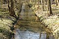
The course of the Niers near the mill

The Niers between Wickrath and Odenkirchen on the map from 1912

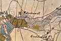
The Niers in Wickrath on the original cadastral map from 1846
The locations Wickrath and Wetschewell on the Tranchot map 1803-1820


literature
- Hans Vogt: Lower Rhine water mill guide 2nd edition. Verein Niederrhein, Krefeld 1998, ISBN 3-00-002906-0 , pages 481-483.
- Robert Lünendonk: The Niers and their mills 1st edition November 2012, ISBN 978-3-8375-0741-6 , pages 39-40, 87-89.
Web links
Individual evidence
- ^ German basic map 1: 5000
- ↑ http://www.lanuv.nrw.de/fileadmin/lanuv/wasser/pdf/Gewaesserverzeichnis%20GSK3C.xls
- ↑ Archived copy ( memento of the original from October 17, 2013 in the Internet Archive ) Info: The archive link was inserted automatically and has not yet been checked. Please check the original and archive link according to the instructions and then remove this notice.
- ↑ http://www.Niersverband.de/
Am Mühlenbach :
Vollmühle
Am Gladbach :
Compesmühle |
Angel Mill |
Tile mill |
Yaw mill |
Krallsmühle |
Supreme Mill |
Tube mill |
Vitgesmühle
An der Niers :
Bellermühle |
Bottmühle Odenkirchen |
Broichmühle |
Burgmühle Odenkirchen |
Eickesmühle |
Güdderather Mühle |
Kappelsmühle |
Nun mill |
Odenkirchen paper mill |
Wickrath paper mill |
Pixmühle |
Pletschmühle |
Wetscheweller mill |
Wickrathberger Mill |
Wilderather Mill |
Rheydt Castle Mill |
Castle mill Wickrath |
Schwalmer Mill |
Stone mill |
Zoppenbroich Mill