
Kappelsmühle
| Kappelsmühle
|
||
|---|---|---|
.jpg) Castle house of the Kappelshof in Wanlo |
||
| Location and history | ||
|
||
| Coordinates | 51 ° 6 '16 " N , 6 ° 24' 58" E | |
| Location |
|
|
| Waters | Niers | |
| Built | 1424 Mentioned in a marriage contract | |
| Shut down | 1870 because of straightening the kidney | |
| technology | ||
| use | Flour mill | |
| Grinder | Grinding mill | |
| drive | 1 water wheel | |
| water wheel | undershot | |

The Kappelsmühle was a watermill with an undershot water wheel on the upper reaches of the Niers in the Mönchengladbach district of Wanlo in the administrative district of Düsseldorf .
geography
The Kappelsmühle was located on the right side of the Niers in the Mönchengladbach district of Wanlo, in the district of Strahlend. Above was the Pletschmühle , below the Wickrathberger Mühle. The area on which the mill building stood is approx. 65 m above sea level .
Waters
The Niers (GEWKZ) 286 in its old river bed supplied numerous mills with water for centuries until the river was straightened . The source of the Niers is in Kuckum , a district of the city of Erkelenz . The Niers has a total length of 117.668 km and a total catchment area of 1,380.630 km 2 up to its confluence with the Meuse near Gennep (Netherlands) . The source is 73 m above sea level. NN , the mouth at 9 m above sea level. NN . The Niersverband is responsible for the care and maintenance of the water .
history
The mill was first mentioned as a grinding mill in a marriage contract from 1424. At that time, the mill belonged to the Zourshof, a Wickrath knight fief . Around 1560 the mill came into the possession of the von Papeler family, who also owned the Papelerhof. In 1595 Regina von Papeler and Wilhelm Coppartz married. Over time, the Papelerhof became the Kappelshof and the mill became the Kappelsmühle. Mill operations were stopped around 1870. The federal motorway 46 now runs over the former location of the mill . From the Kappelshof a riding stable with a breeding and training stable developed, the Gut Kappelshof .
gallery

The Kappelshof estate
The Kappelshof on the map Newly added from 1912

The location Radiant on the original cadastral map from 1846

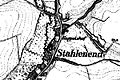
The Kappelsmühle on the Tranchot map 1803–1820


Monument entry
Former castle house of Kappelshof Entry as a memorial on January 30, 1992
The Kappelshof is located west of the edge of the terrace in the Niersaue on the road from Wanlo to Wickrathberg . The building is a five-storey, three-axis brick building under a steep pitched roof with elevated gable areas. All gable and eaves sides with several S-shaped anchor pins. The property is worth protecting as a monument for local and settlement history as well as for architectural reasons.
literature
- Hans Vogt: Lower Rhine water mill guide 2nd edition. Niederrhein Association, Krefeld 1998, ISBN 3-00-002906-0 , page 479.
- Robert Lünendonk: The Niers and their mills 1st edition November 2012, ISBN 978-3-8375-0741-6 , pages 28-30, 83-84.
Web links
- Fishing on the Niers
- Interesting facts about the Niers
- Monument Former castle house of the Kappelshof
- Website of Gut Kappelshof
- Website of the place Wanlo
Individual evidence
- ^ German basic map 1: 5000
- ↑ http://www.lanuv.nrw.de/fileadmin/lanuv/wasser/pdf/Gewaesserverzeichnis%20GSK3C.xls
- ↑ Archived copy ( memento of the original from October 17, 2013 in the Internet Archive ) Info: The archive link was inserted automatically and has not yet been checked. Please check the original and archive link according to the instructions and then remove this notice.
- ↑ http://www.Niersverband.de/
Am Mühlenbach :
Vollmühle
Am Gladbach :
Compesmühle |
Angel Mill |
Tile mill |
Yaw mill |
Krallsmühle |
Supreme Mill |
Tube mill |
Vitgesmühle
An der Niers :
Bellermühle |
Bottmühle Odenkirchen |
Broichmühle |
Burgmühle Odenkirchen |
Eickesmühle |
Güdderather Mühle |
Kappelsmühle |
Nun mill |
Odenkirchen paper mill |
Wickrath paper mill |
Pixmühle |
Pletschmühle |
Wetscheweller mill |
Wickrathberger Mill |
Wilderather Mill |
Rheydt Castle Mill |
Castle mill Wickrath |
Schwalmer Mill |
Stone mill |
Zoppenbroich Mill