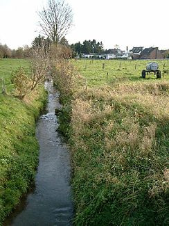
Kohm
| Kohm | ||
|
The Köhm between Borschemich and Keyenberg |
||
| Data | ||
| Water code | DE : 286114 | |
| location | North Rhine-Westphalia , Germany | |
| River system | Rhine | |
| Drain over | Niers → Maas → Hollands Diep → North Sea | |
| River basin district | Meuse | |
| muzzle | North of Keyenberg in the Niers Coordinates: 51 ° 5 ′ 17 ″ N , 6 ° 24 ′ 21 ″ E 51 ° 5 ′ 17 ″ N , 6 ° 24 ′ 21 ″ E |
|
| Mouth height |
69 m above sea level NN
|
|
| length | 5.3 km | |
| Catchment area | 44.699 km² | |
The Köhm is a small watercourse / drainage ditch in the eastern part of the urban area of Erkelenz . Due to the Garzweiler opencast mine , the Köhm will be gone in a few decades.

course
The original beginning of the Köhm was in the area between Garzweiler and Kaiskorb. The watershed between Erft ( Rhine ) and Rur / Niers ( Maas ) lay at a height of 120 m above sea level . From here the Köhm flowed north past Alt- Otzenrath . The area between Garzweiler and Otzenrath is now in the excavated area of the opencast mine.
Coming from Otzenrath, the Köhm runs in a west-east direction in a narrow valley at a height of 74 to 78 m above sea level through the village of Borschemich , then north of Keyenberg directly past the former manor house Keyenberg, and finally into the Niers to flow.
It is only a flowing body of water after heavy rainfall and when the snow melts . In some cases, feed-in takes place through drainage measures for the Garzweiler opencast mine. From the entrance to Borschemich the Köhm is canalised and only continues to flow openly from Marienstiftstraße next to the rectory. The trench system of Haus Paland used to be fed by the Köhm in Borschemich , some of the trenches are still preserved. In the past, water also flowed into the Köhm from the Keyenberg trench system, which in turn was fed by springs.
history
The place Borschemich was as Brismike first mentioned in 898 in a document. In 1396 the name appears as Bursmich , in 1618 as Borschemich . The interpretation of the place name cannot be clearly clarified. The basic word - Bach means me and could refer to the Köhm , which was a stronger body of water in the early Middle Ages .
Kohm song
Traditional Köhm song in Borschemich dialect :
Et Kue'hm Leed
Kütt dr Sonnachnommedach
wehs kehner us noch en
löf dat Dres de Stros eraf
flöck nom uncle
saw em then jet in et Uer
hei dat wütt jemaat he
dat jöff en special tour he
dat jöff en drive
Jo I drive with a Böötche whether dr Kue'hm
allemole un et Dres with singing Ühem
un dat Dres dat kritt dr zedder
be demm janz glitter
jo no mod - jo no mod - jo no mod
allemole op the small paddle boat!
Individual evidence
- ^ German basic map 1: 5000
- ↑ a b Topographical Information Management, Cologne District Government, Department GEObasis NRW ( Notes )

