Gmina Miłoradz
| Gmina Miłoradz | ||
|---|---|---|

|
|
|
| Basic data | ||
| State : | Poland | |
| Voivodeship : | Pomerania | |
| Powiat : | Malbork | |
| Geographic location : | 54 ° 1 ' N , 18 ° 55' E | |
| Residents : | see Gmina | |
| Postal code : | 82-213 | |
| Telephone code : | (+48) 55 | |
| License plate : | GMB | |
| Gmina | ||
| Gminatype: | Rural community | |
| Gmina structure: | 12 localities | |
| 9 school offices | ||
| Surface: | 93.75 km² | |
| Residents: | 3357 (June 30, 2019) |
|
| Population density : | 36 inhabitants / km² | |
| Community number ( GUS ): | 2209062 | |
| Administration (as of 2010) | ||
| Wójt : | Tadeusz Biliński | |
| Address: | ul. Żuławska 9 82-213 Miłoradz |
|
| Website : | www.miloradz.malbork.pl | |
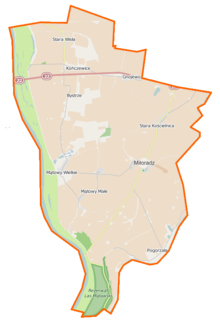
The Gmina Miłoradz is a rural community in the powiat Malborski ( German Marienburg ) in the Polish Pomeranian Voivodeship . It has an area of 93.75 km², on which 3357 people live (June 30, 2019). Their seat is the village of the same name (Mielenz) .
geography
The rural community is located in the area of the Great Marienburger Werder in the former West Prussia . Neighboring communities are the rural communities Malbork , Lichnowy , Pelplin , Subkowy , Sztum and Tczew (Dirschau) . 82% of the area is used for agriculture, 3% is forest. There are several nature reserves. The area of the rural community is bounded by the Vistula and Nogat rivers.
history
From 1975-1998 Miłoradz belonged to the Elbląg Voivodeship .
Gmina Mątowy Wielkie
From 1945 to 1954 the Gmina Mątowy Wielkie existed with its seat in the village of the same name.
Community structure
Schulzenämter
The rural community Miłoradz includes the nine localities listed in the table, each with a school administration office .
| Polish name | German name (until 1945) |
Pop. (2006) |
location | image |
|---|---|---|---|---|
| By-falls | Biesterfelde | 220 | (Location) |

|
| Gnoyevo | Gnojau | 240 | (Location) |

|
| Kończewice | Kunzendorf | 700 | (Location) |

|
| Mątowy Małe | Little Montau | 200 | (Location) |

|
| Mątowy Wielkie | Great Montau | 353 | (Location) |

|
| Miłoradz | Mielenz | 240 | (Location) |

|
| Pogorzała Wieś | Wernersdorf | 400 | (Location) |

|
| Stara Kościelnica | Altmünsterberg | 250 | (Location) |

|
| Stara Wisła |
Alt Weichsel ( Alt Weichsel ) |
190 | (Location) |

|
Other localities in the municipality
Other places in the rural community are: Cyganki (goats) , Kłosowo (Klossowo) , Rękowo (noble Renkau) and settlements in the villages of Mątowy Wielkie, Miłoradz and Stara Wisła.
Listed sights
- Parish church in Gnojewo
- Ruins of the Evangelical Church in Gnojewo, 14th, 15th and 19th centuries
- Parish church in Kończewice, 14th and 15th centuries
- Parish church in Mątowy Wielkie, 1340
- Parish Church in Miłoradz, 14th and 15th centuries; Cemetery etc.
- Parish church in Stara Kościelnica, 1400 and 1816
- Cemetery crypt in Bystrze, 14th century
- Vorlaubenhaus in Bystrze
Personalities
- Peter von der Osten-Sacken (* 1940 in Gnojau), Protestant theologian.
Web links
literature
- Piotr Skurzyński: Warmia, Mazury, Suwalszczyzna . Muza, Warszawa 2004. p. 59. ISBN 83-7200-631-8 .
Individual evidence
- ↑ population. Size and Structure by Territorial Division. As of June 30, 2019. Główny Urząd Statystyczny (GUS) (PDF files; 0.99 MiB), accessed December 24, 2019 .
- ↑ The Historical Place Directory


