Golberode
|
Golberode
Municipality Bannewitz
Coordinates: 50 ° 59 ′ 1 ″ N , 13 ° 45 ′ 10 ″ E
|
|
|---|---|
| Height : | 267–290 m above sea level NN |
| Residents : | 114 (December 31, 2012) |
| Incorporation : | 1958 |
| Incorporated into: | Goppeln |
| Postal code : | 01728 |
| Area code : | 0351 |
|
Location of Golberode in Bannewitz
|
|
Golberode is a district of the Saxon municipality of Bannewitz in the district of Saxon Switzerland-Eastern Ore Mountains .
geography
The place is east of the main town. State road 191 runs to the north . Golberode is located on the southern flank of the Gebergrund (landscape protection area).
history
The place was first mentioned in 1288 as Holbrode , then in 1425 as Gollebrode (bald beards). To 1552 Golberode had a feud . The resident farms along the ascending village street were subjects of the manor of the Bärenklause manor . In addition, there was a patrimonial jurisdiction in the place until 1856 . In 1954 the LPG friendship was founded.
In 1857 the Dippoldschacht coal mine was sunk. In 1859 the Hornschänke, which still exists today, opened on the shaft site. The daytime facilities of the shaft, however, were removed in 1873/74. From 1885 sandstone was quarried near Golberode .
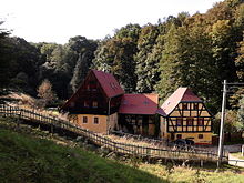
There is a mill in the Gebergrund below the old forge . It is the topmost of the three former mills (Gaustritzer Mühle, Goppelner Mühle and Golberoder Mühle). The Golberoder mill was mentioned as early as 1547 as "small mill". It had a grinding passage for making grist , this was abandoned in the course of the mill reform in Saxony, the mill technology was dismantled and the mill ditch filled.
Others
- The head of the village is Elke Schlerife (BG). (As of December 2015)
Web links
- Golberode in the Digital Historical Directory of Saxony
- Golberode at www.bannewitz.de
Individual evidence
- ↑ Municipal administration Bannewitz: Presentation of the districts of Bannewitz
- ↑ Land Registry Dippoldiswalde


