Goldbach (Aschaff)
|
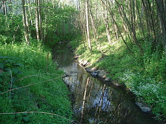
Goldbach Unterlauf: flood ditch |
||
|
The flood ditch near Goldbach |
||
| Data | ||
| location |
Spessart
|
|
| River system | Rhine | |
| Drain over | Aschaff → Main → Rhine → North Sea | |
| source | southwest of Unterafferbach 50 ° 0 ′ 49 ″ N , 9 ° 9 ′ 51 ″ E |
|
| Source height | approx. 235 m above sea level NHN | |
| muzzle | as a flood ditch in Aschaffenburg from the right into the Aschaff coordinates: 49 ° 59 '26 " N , 9 ° 9' 46" E 49 ° 59 '26 " N , 9 ° 9' 46" E |
|
| Mouth height | approx. 129 m above sea level NHN | |
| Height difference | approx. 106 m | |
| Bottom slope | approx. 37 ‰ | |
| length | approx. 2.9 km to the flood ditch approx. 4.4 km including the flood ditch |
|
| Catchment area | approx. 3.9 km² | |
| Right tributaries | Klingenbach | |
|
Crossing of the Goldbach into the flood ditch |
||
|
Today's confluence with the Aschaff |
||
The Goldbach is a brook in the Bavarian Spessart , which flows into the Aschaff from the right on the eastern edge of the urban area of Aschaffenburg . Its artificially created lower course in the flood plain is called the flood ditch .
Surname
The name " Goldbach " comes from the yellowish loess earth and an iron-containing mineral spring at one of its tributaries, which color the sediments of the stream bed golden yellow. He gave the place Goldbach its name.
geography
course
The Goldbach rises southwest of Unterafferbach am Grauenstein ( 308 m above sea level ). It flows in a south-easterly direction, first accompanied by steep embankments still in the forest through the Kirschdelle , then past the forest swimming pool next to the main road following the valley basin to the center of the village of Goldbach . It is completely piped within the village. After the end of the pipework, the Goldbach used to flow into the Aschaff after about 200 m across its right floodplain .
Today, on the other hand, it bends west just before the B 26 and runs along the new parallel run to the Aschaff in the bed of the former flood ditch . This 1.4 km long lower course was dug in 1923 as the right branch of the Aschaff to divert its flood; a connection from this no longer exists today. The flood ditch initially runs next to newer large commercial buildings and continues downhill on the western edge of the development of the village of Goldbach, just in the city of Aschaffenburg from the right on the Klingenbach . After that, a few steps before the underpass of Dammer Strasse under the A 3, it crosses it itself and flows right into the Aschaff on the other side.
Catchment area
The Goldbach drains an area on the right slope of the Aschaff Valley of around 3.9 km². It extends from the summit of 308 m above sea level. NHN high Grauenstein in the north-north-west, at the same time the highest point of the catchment area, about 2½ km to the south-south-west to the left bank of the lower course parallel to the Aschaff Flutgraben ; across it the extension reaches a little more than 2 km at the widest point. The lowest point at the mouth is just under 129 m above sea level. NHN .
In the north and east, the catchment area of the Aschaff tributary borders Hösbach , with its right tributary for the most part competing with Afferbach , in the west that of the Glattbach , which reaches below the Aschaff.
Tributaries
- Klingenbach ( right, temporarily dry )
Aschaff river system
See also
Web links
Individual evidence
- ↑ According to the contour line image on the BayernAtlas of the Bavarian State Government ( notes ).
- ↑ According to the contour line image on the BayernViewer, which shows one-meter lines in the Aschaff-Aue.
- ↑ a b Measured using Google Earth. Length was determined from the source to the transition into the flood ditch; up to the mouth of the flood ditch in the Aschaff results in a length of 4.4 km.
- ↑ Measured on the BayernViewer.
- ^ Wolf-Armin von Reitzenstein : Lexicon of Franconian place names. Origin and meaning . Upper Franconia, Middle Franconia, Lower Franconia. CH Beck, Munich 2009, ISBN 978-3-406-59131-0 , p. 84–85 ( limited preview in Google Book search).
- ↑ BayernViewer, historical map series from the years 1817–1841.
- ↑ Measured on the BayernViewer.
- ↑ Information sign at the flood ditch.


