
Green Heath (Elbe-Elster)

The Green Heath is a forest area in the Elbe-Elster area that has always been mainly used for forestry and hunting purposes.
It is located in the Elbe-Elster lowlands . The approximately 600 hectare area is currently largely part of the urban area of the southern Brandenburg spa town of Bad Liebenwerda , where it extends between the districts of the urban districts of Möglenz , Kosilenzien , Neuburxdorf , Burxdorf and Langenrieth and Saxdorf , district of the city of Uebigau-Wahrenbrück .
history
Historical development
The Green Heath was first mentioned in a document in 1282 as Gnmeheyde . Originally, most of the forest area belonged to the Mühlberger Kloster Marienstern (formerly also called Güldenstern ), which when it was dissolved in 1540 also owned a number of other lands, rights and villages in the area, which brought it income. This also applies to the villages of Saxdorf and Kauxdorf on the heath as well as part of the village of Möglenz.
The idea of developing the area for tourism, which is currently being looked after by the Möglenz Forestry Department, which is part of the Elsterwerda Forestry Department, arose in 2016/2017 during the Places in Responsibility project , in which the six villages of Möglenz, Kosilenzien, Neuburxdorf, Burxdorf, Langenrieth are located and Saxdorf merged to create visions and objectives for the future village development of the region. The aim is to establish gentle, natural tourism here. Hiking trails that have yet to be marked with display boards will in future run in a star shape to the core area of the Green Heath and thus provide information on the natural and historical features of the region.
Culture and sights
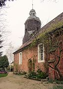
Saxdorf village church
Langenrieth village church

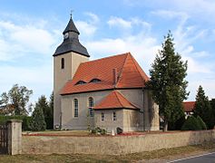
Burxdorf village church
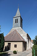
Kosilenzien village church
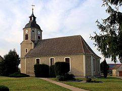
Möglenz village church


Buildings
In the villages adjacent to the Green Heath you can find some historical church buildings, all of which are currently listed. The oldest surviving village churches are in Saxdorf and Burxdorf. The village church in Saxdorf was built in the 13th century. It has been the focus of many cultural events for decades. The Saxdorfer Pfarrgarten, designed by the artist Hanspeter Bethke , was voted one of the most beautiful gardens in the Berlin-Brandenburg region by viewers of Rundfunk Berlin-Brandenburg (RBB) in 2013.
The village church of Burxdorf also dates from the 13th century . The early Gothic hall building with a retracted rectangular choir can be found in the center of the village with a cemetery surrounding it on the village green .
The village church of Kosilenzien is now the third church in town. It can be found in the center of the village with a cemetery surrounding it . The first previous building from 1597 fell victim to a fire in 1812. The subsequent building, built in 1816, collapsed unfinished. The church structure that still exists today is a plastered hall with beveled corners on the east side. To the west is a square church tower that merges into an octagonal shape.
The previous building of the village church in Möglenz also fell victim to a devastating village fire in 1817. The building that exists today is a plastered, late-Gothic brick hall building from the years 1819/20 with a three-sided east end.
The youngest church in the area is the village church in Langenrieth . It can be found in the center of Langenrieth with a cemetery surrounding it and dates from 1913. Most of the furnishings from the previous building are now a listed building .
Memorials Neuburxdorf
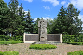
Main monument at the Neuburxdorf military cemetery

Grave crosses on the grounds of Stalag IV B
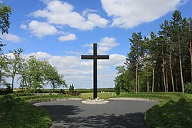
Memorial on the grounds of Stalag IV B


There are several memorials in Neuburxdorf . In the district of the town in the south of the Greens Heide arose after the seizure of power of the Nazis in World War II in 1939 the POW camp Stalag IV-B (Stalag IV B) of the Wehrmacht . Up to 16,000 men could be held at the same time in this 30 hectare camp. Around 3000 prisoners of war from all over the world lost their lives in the Neuburxdorf prisoner of war camp until the end of the war.
Stalag IV B was taken over by the Red Army at the end of the war . From September 1945 the camp was called Special Camp No. 1 Mühlberg . First of all, after the dissolution of Stalag IV B, former Eastern workers, prisoners of war and members of the Vlasov Army were detained on the site . Later, people followed who were accused of membership in the NSDAP, a function in National Socialist Germany, espionage or other threats to the occupation regime. Of the approximately 22,000 people who passed through the camp up to 1948, approximately 7,000 did not survive imprisonment. The dead were buried in mass graves.
A memorial is now located on the former camp site, which was partially reforested during the GDR era. Another memorial in the village is the Neuburxdorf military cemetery , where around 600 prisoners of war were buried.
Web links
Individual evidence
- ↑ a b c Mona Claus: Visions in the forest of the six villages in Lausitzer Rundschau , March 24, 2017.
- ↑ a b series of publications by the Dresden State Archives . tape 6 , 1960, pp. 487 .
- ↑ August Schumann : Complete State, Post and Newspaper Lexicon of Saxony, containing a correct and detailed geographical, topographical and historical representation of all cities, towns, villages, castles, courtyards, mountains, forests, lakes, rivers, etc., the entire Royal. and Prince. Saxon country including the Principality of Schwarzburg, the Erfurt area, as well as the Reussian and Schönburg possessions. tape 6 . Zwickau 1819. → [1]
- ^ Article about Saxdorf in the RBB show Landschleicher from June 23, 2013.
- ↑ Database of the Brandenburg State Office for the Preservation of Monuments and the State Archaeological Museum ( Memento of the original from December 9, 2017 in the Internet Archive ) Info: The archive link has been inserted automatically and has not yet been checked. Please check the original and archive link according to the instructions and then remove this notice. , accessed November 25, 2016.
- ↑ Database of the Brandenburg State Office for the Preservation of Monuments and the State Archaeological Museum ( Memento of the original from December 9, 2017 in the Internet Archive ) Info: The archive link has been inserted automatically and has not yet been checked. Please check the original and archive link according to the instructions and then remove this notice. , accessed October 22, 2016.
- ↑ Database of the Brandenburg State Office for the Preservation of Monuments and the State Archaeological Museum ( Memento of the original from December 9, 2017 in the Internet Archive ) Info: The archive link has been inserted automatically and has not yet been checked. Please check the original and archive link according to the instructions and then remove this notice. , accessed November 5, 2016.
- ^ Georg Dehio : Handbook of German Art Monuments - Brandenburg . 2nd Edition. 2012, ISBN 978-3-422-03123-4 , pp. 704 .
- ↑ Database of the Brandenburg State Office for the Preservation of Monuments and the State Archaeological Museum ( Memento of the original from December 9, 2017 in the Internet Archive ) Info: The archive link has been inserted automatically and has not yet been checked. Please check the original and archive link according to the instructions and then remove this notice. , accessed November 5, 2016.
- ↑ Database of the Brandenburg State Office for the Preservation of Monuments and the State Archaeological Museum ( Memento of the original from December 9, 2017 in the Internet Archive ) Info: The archive link has been inserted automatically and has not yet been checked. Please check the original and archive link according to the instructions and then remove this notice. , accessed October 17, 2016.
Coordinates: 51 ° 28 ′ 31.6 ″ N , 13 ° 18 ′ 6.6 ″ E