
Green heads
| Green heads | ||
|---|---|---|
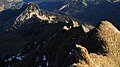
 Green heads from the Winterstaude (1877 m) from the northwest |
||
| height | 1725 m above sea level A. | |
| location | Vorarlberg , Austria | |
| Mountains | Northwestern Walsertal Mountains , Allgäu Alps | |
| Dominance | 0.6 km → Diedamskopf | |
| Notch height | 145 m ↓ notch to the Diedamskopf | |
| Coordinates | 47 ° 21 '33 " N , 10 ° 2' 11" E | |
|
||
| rock | Drusberg layers ( Helvetic ) | |
| Age of the rock | Barremium / Aptium | |
| Normal way | Eastern flank (III) | |

The Green Heads are a double peaks, 1725 m above sea level. A. high mountain in the Allgäu Alps in the Austrian state of Vorarlberg .
Location and surroundings
The mountain , located in the sub-group Northwest Walsertal Mountains , rises from the northeast ridge of the Diedamskopf (2090 m). The two mountains are separated by a notch, which is the reference for the notch height of 145 meters of the Green Heads. To the north, the Mohrenkopf slopes down to the Schönenbach pass (1025 m). The Subersach flows to the east . The rock face rises next to it, stretching from the Hählekopf (2058 m) to the Hohen Ifen (2229 m). To the west runs a parallel ridge that carries the Mohrenkopf (1645 m).
The district where the Green Heads are located is Bezau .
Ascent
The ascent of the mountain, which consists of extremely steep and densely overgrown flanks, is difficult. The easiest access is from the gap between the peaks over the eastern flank. Because of this to be dealt with steep grass -Kletterei ( III ) is for absolute surefootedness and head for heights required.
gallery

With green heads from the south
From the south with the Diedamskopf northeast ridge

From the east

With green heads from the northwest


Web links
Individual evidence
- ↑ a b Dieter Seibert: Alpine Club Guide alpine - Allgäu Alps and Ammergau Alps . 17th edition. Bergverlag Rother, Munich 2008, ISBN 978-3-7633-1126-2 (p. 173).
- ^ Herbert Scholz: Building and Becoming the Allgäu Landscape . E. Schweizerbart'sche Verlagsbuchhandlung (Nägele and Obermiller), Stuttgart 1995, ISBN 3-510-65165-0 (p. 92).
- ↑ Exact value not known, stated value is a minimum value (can be up to 19 meters higher). It was determined from the distance between the contour lines (20 meters in altitude ) on a topographic map ( scale 1: 25,000).
- ^ Federal Office for Metrology and Surveying Austria: Austrian Map online (Austrian map 1: 50,000) . Retrieved January 25, 2012.