
Hollow head
| Hollow head | ||
|---|---|---|
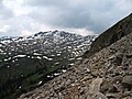
 Hehlekopf south flank of the Kreuzmandl |
||
| height | 2058 m above sea level A. | |
| location | Vorarlberg , Austria | |
| Mountains | Northwestern Walsertal Mountains , Allgäu Alps | |
| Dominance | 2.1 km → Hoher Ifen | |
| Notch height | 138 m ↓ notch to Hohen Ifen | |
| Coordinates | 47 ° 20 '48 " N , 10 ° 4' 14" E | |
|
||
| Type | Grasberg | |
| rock | Schrattenkalk ( Helvetic chalk ) | |

The Hehlekopf (also Hehlekopf or Hellekopf ) is 2058 m above sea level. A. high mountain in the Allgäu Alps in the Austrian state of Vorarlberg .
Location and surroundings
The mountain , located in the northwestern Walsertal Mountains subgroup , forms the western end of the Schwarzwassertal valley and towers over the Subersach valley in the southeast. As the southern end point, it rises from the arch of steep rock faces that run from the Sevischrofen (1659 m), the Hohen Ifen (2229 m) and Berlingersköpfle (2010 m) here. To the south, the flanks of the Hählekopf drop down to the Gerachsattel (1752 m) and from there rise to the Steinmandl (1982 m). To the west the area goes over to the Diedamskopf (2090 m). The notch height of the Hählekopf is at least 138 meters.
The district on which the Hählekopf is located is Egg , which is 16 kilometers away. The border with the municipality of Bezau also runs over the summit . The closest town is Schoppernau at a distance of approximately 5.5 kilometers.
Origin of name
In 1866, Hellekopf was first mentioned on a map of Austria with Hellekopf . As eponymous, the cock comes into question, with which the cock's head would be related in the Allgäu language. It would also be possible to use the dialectic term “hal” for slippery or slippery.
Ascent
The Schwarzwasserhütte (1620 m) in the Schwarzwassertal serves as a base for an ascent of the Hählekopf . The Neuhornbachhaus (1650 m) above the Bregenz Ach valley is also not far away.
summer
There is no marked hiking trail to the pyramid of the Hählekopf and it is climbed either from the east or the south. An ascent is carried out either over the Ifersgundalpe (1750 m) or the Gerachsattel. An alternative access via the Hohen Ifen also leads from the east. The southern variant over the Gerachsattel can also be started from the Neuhornbachhaus or the Schönenbach pass . In the summit area the terrain steepens.
winter
In winter the Hählekopf is a ski tour destination . Here, too, an access over the Gerachsattel is possible and the German Alpine Association marked . The route from the Schwarzwassertal is also marked between the valley floor and the Ifersgundalpe, as it leads through a wilderness area. The summit can also be reached with snowshoes .
gallery
Northeast flank

Northwest flank

South-east flank with Schwarzwasserhütte
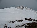
summit

South side of the Gerachsattel


Web links
Individual evidence
- ↑ Ernst Zettler, Heinz Groth: Alpine Club Guide - Allgäu Alps. 12th, completely revised edition. Bergverlag Rudolf Rother, Munich 1985, ISBN 3-7633-1111-4 (p. 512).
- ↑ a b Thaddäus Steiner : Allgäu mountain names . 2nd Edition. Kunstverlag Josef Fink, Lindenberg 2008, ISBN 978-3-8987-0389-5 (p. 73).
- ↑ Ernst Zettler, Heinz Groth: Alpine Club Guide - Allgäu Alps. 12th, completely revised edition. Bergverlag Rudolf Rother, Munich 1985, ISBN 3-7633-1111-4 (p. 556).
- ↑ Exact value not known, stated value is a minimum value (can be up to 19 meters higher). It was determined from the distance between the contour lines (20 meters in altitude ) on a topographic map ( scale 1: 25,000).
- ↑ Dieter Seibert: Alpine Club Guide alpine - Allgäu Alps and Ammergau Alps . 17th edition. Bergverlag Rother, Munich 2008, ISBN 978-3-7633-1126-2 (p. 170).
- ↑ Kristian Rath: Allgäu ski tour guide with Kleinwalsertal and Tannheimer Tal . 6th edition. Panico Alpinverlag, Köngen 2009, ISBN 978-3-9367-4010-3 (p. 34 f.).