Grafenberg (Schorndorf)
| Grafenberg | ||
|---|---|---|
|
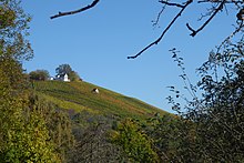
Vineyards on the Schorndorfer Grafenberg |
||
| height | 361 m above sea level NN | |
| location | Rems-Murr-Kreis , Baden-Wuerttemberg | |
| Mountains | Berglen | |
| Coordinates | 48 ° 49 '0 " N , 9 ° 30' 30" E | |
|
|
||
| rock | Keuper ; Pebble sandstone | |
The Grafenberg is 361 m above sea level. NN high elevation in the northern urban area of Schorndorf in Baden-Württemberg . He is the namesake of a vineyard in the Württemberg wine-growing region and part of a larger landscape conservation area .
geography
The Grafenberg is located about 2 km northwest of the Schorndorf market square about 100 m above the Remspegel . To the west the Ramsbach drains the mountain flank, (north) east the Schornbach . The Rems itself comes close to the foot of the mountain in a loop southeast at about 500 m.
The summit of the Keuperberg consists of harder silica sandstone , while on the slope - from bottom to top - the following rocks are on the surface: gypsum keuper , reed sandstone and lower colored marl . To the north-west, the Grafenberg merges with a very low notch height (<10 m) into the next higher layer level ( Upper Colorful Marl or Stubensandstein ).
In terms of natural space, the mountain lies roughly on the border between the subunits Berglen (number 107.2) and Remstal (number 107.1) within the main unit Schurwald and Welzheimer Wald (number 107).
To the south and east, the four-lane federal highway 29 touches the foot of the elevation and is led through a 260 m long tunnel ( Grafenberg tunnel ) that penetrates the eastern foothills of the Grafenberg in the area of the Gipskeupers .
A few meters from the highest point, a lookout point with a barbecue area offers a beautiful view of the Remstal and the Schurwald forest opposite , especially the Ottilienberg and Galgenberg . To the north there is a parking lot for hikers, to which a narrow street leads up from Schorndorf.
Viticulture
The vineyards on Grafenberg were first mentioned in 1290; the name can be traced back to the local property of the Württemberg counts . Today the Grafenberg, under the name Schorndorfer Grafenberg, is assigned to the easternmost vineyard in the Remstal and the large area of Korber Kopf ; The vines on the neighboring Sünchen also belong to him. Today only the slopes facing south and south-east are used for viticulture; the south-west slopes (towards Ramsbachtal) are used as orchards and gardens.
Various wineries in the area and cooperatively organized winemakers manage the vineyards. The city of Schorndorf also has land that is leased and on which the Schorndorf “city wine” grows.
Landscape protection area
The Grafenberg is part of the large protected landscape area Zipfelbachtal, Korber Kopf, Buocher Höhe, Remstal slopes, Ramsbachtal and Grafenberg .
Others
The Grafenbergschule at the Schorndorfer Vocational School Center is named after the mountain.
swell
- Geographical information according to: State Office for Geoinformation and Rural Development Baden-Württemberg: TopMaps. Leisure maps 25th edition 2011 (DVD), Stuttgart 2011, ISBN 978-3-89021-795-6 .
- Exact outline of the vineyard
Individual evidence
- ↑ a b State Office for Geology, Raw Materials and Mining Baden-Württemberg: Geological map of the Swabian-Franconian Forest Nature Park 1:50,000. Freiburg im Breisgau 2001.
- ^ Federal Institute for Regional Studies and Spatial Research: Geographische Landesaufnahme 1: 200,000. Sheet 171: Göppingen (pdf; 4.6 MB). Bad Godesberg 1961.
- ↑ Wirtemberg document book . Volume IX, No. 3933. Stuttgart 1907, p. 328 ( digitized , online edition )
- ↑ Royal statistical-topographical Bureau (ed.): Description of the Oberamt Schorndorf. JB Müller's Verlagshandlung, Stuttgart 1851, p. 99; Full text online at the University and State Library in Düsseldorf .


