Grafensundern
| Grafensundern | ||
|---|---|---|
|
View from Borgberg eastwards over Hagen - Mentrup |
||
| height | 314.9 m above sea level NHN | |
| location | at Hagen aTW ; District of Osnabrück , Lower Saxony ( Germany ) | |
| Mountains | Teutoburg Forest | |
| Coordinates | 52 ° 10 '52 " N , 8 ° 2' 8" E | |
|
|
||
| rock | Osning sandstone | |
| particularities | Grafensundern telecommunications tower | |
The Grafensundern is with a height of 314.9 m above sea level. NHN after the Dörenberg ( 331.2 m ) the second highest mountain in the Iburg Forest, a foothill of the Teutoburg Forest . It belongs to the municipality of Hagen am Teutoburg Forest in the district of Osnabrück in Lower Saxony .
The characteristic rock in the Iburg Forest is the Osning sandstone , named after "Osning", an earlier name for the Teutoburg Forest. The Grafensundern telecommunications tower stands on the top .
geography
location
The Grafensundern rises in the Iburg Forest and in the TERRA.vita nature and geopark . Its summit is 3 km northwest of Bad Iburg . In the northwest, the elevation borders the Baumannsknollen ( 245 m ). To the southeast the landscape leads over a mountain ridge to the Dörenberg. In the south rises beyond the Sunderbach, a source brook of the Glaner Bach , the Urberg ( 218.1 m ). Along the historical demarcation of the Grafensundern, the borders with the town of Georgsmarienhütte (Oesede district) on the northern side and the town of Bad Iburg on the southern and eastern side run today . At Karlsplatz between Grafensundern and Dörenberg, all three town borders meet at Schnatgangstein .
Parts of the Teutoburg Forest landscape protection area are located on the Grafensundern ( CDDA no. 329212; 2004 designated; 113.699 km² ).
Natural allocation
The Grafensundern belongs to the natural spatial main unit group Lower Weserbergland (No. 53), the main unit Osnabrücker Osning (534) and the subunit Ohrbecker Heights (534.0) to the natural area Dörenberg (534.01).
history
Quite a few Iburg forest areas can be assigned to previous owners using various boundary markings. The oldest boundary stone found so far near Bad Iburg dates back to 1732. The boundary stones, mostly made of sandstone, provide information about the ownership structure. A distinction is made between the property of the prince-bishops, monastery property and private property. In addition, border walls were also built to mark the area. The Grafensundern belonged to the Iburger prince-bishops . The area ends in a westerly direction on the Achter de Welt road .
Grafensundern telecommunications tower
The Grafensundern telecommunications tower is on top of the Grafensundern . The tower is a steel frame construction built around 1965 and about 60 m high. It is used for broadcasting digital audio broadcasting , cellular and directional radio, as well as the amateur radio service .
Holy House
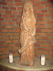
A few meters north of the main road 96 is located near the beginning of the leading on the southern slope of the Count Sundern carousel road a Heiligenhäuschen ( ⊙ ). It is a half-open brick building about 2.5 m high. The figure of Mary carved from wood stands on a pedestal .
Traffic and walking
The state road 96 runs south of the Grafensundern in the valley of the Sunderbach , which branches off the federal road 51 in the south-east in Bad Iburg and leads to Hagen in the north-west. From the L 96, the Karussellstraße branches off south-southwest of the elevation , which leads as an asphalt access road to the military radio tower of the Dörenberg. From Karlsplatz , which lies on the ridge between the two mountains, the ridge path branches off from this access road to Grafensundern. In addition, the elevation is accessible through several hiking trails, including the Hermann-Wesseler-Weg and Grafensundernweg .
See also
- List of mountains and elevations in Lower Saxony
- List of mountains and elevations in the Teutoburg Forest
Individual evidence
- ↑ a b Topographic map : with the Grafensundern ( memento of the original from November 4, 2016 in the Internet Archive ) Info: The archive link was inserted automatically and has not yet been checked. Please check the original and archive link according to the instructions and then remove this notice. (DTK 25), on natur-erleben.niedersachsen.de
- ↑ Second Teutoburg Forest Ridge , on geo-iburg.de
- ↑ Map services of the Federal Agency for Nature Conservation ( information )
- ^ Sofie Meisel: Geographical Land Survey: The natural space units on sheet 83/84 Osnabrück / Bentheim. Federal Institute for Regional Studies, Bad Godesberg 1961. → Online map (PDF; 6.4 MB)
- ↑ If stones could talk, ... historic boundary stones in the Iburg region , on geo-iburg.de (PDF; 16.51 MB)


