
1881 border treaty between Chile and Argentina
The border treaty of 1881 between Chile and Argentina drew the complete land border between the two countries and was signed in Buenos Aires on July 23, 1881 by Bernardo de Irigoyen (for Argentina ) and Francisco de Borja Echeverría (for Chile ). The treaty consists of a preamble and seven articles that define the 4000 km long border. Articles 1 to 3 stand for the actual delimitation. It has remained unchanged since then, and despite many difficulties and tensions, there has never been a war between the two countries.

The situation before the treaty of 1881
Both countries had separated from Spain in 1810 , but sovereignty could only be secured in the wake of the liberation of Peru in 1820. Chile achieved a stable form of government with the constitution of 1833 under Diego Portales Palazuelos . Argentina did not unite to form a closed republic until 1861 after the Battle of Pavón.
For the European powers Patagonia and Tierra del Fuego were ownerless territories that were completely under the control of the Mapuche and Tehuelche Indians for more than 300 years . The European maps of the time show three or more countries in the southernmost region of America: Chile, Argentina, Patagonia and Tierra del Fuego. Or they show Tierra del Fuego as an appendage to the Falkland Islands . Jules Verne describes in Die Schiffwüchigen der "Jonathan" the view of Europe as follows:
"The separated geographical location meant that this part of the New World had not been incorporated into any civilized state until 1881, not even its closest neighbors Chile and the Republic of Argentina ..., The Magalhães Archipelago did not belong to anyone ..."
Great Britain had occupied the Falkland Islands in 1830 and a similar occupation of the Strait of Magellan by France, the USA or again by Great Britain was expected.
On May 21, 1843 Chile took possession of the Strait of Magellan , founded Fuerte Bulnes and shortly afterwards Punta Arenas, which served as a port for the growing shipping between the Pacific and the Atlantic .
In 1856, the two countries agreed in a treaty to maintain the limits of colonial administration, i.e. to apply the uti possidetis principle. However, these colonial borders were imprecise and were sometimes interpreted as contradicting, especially since the geography and topography of the country were only roughly known. The Beagle Channel was only discovered in 1830, twenty years after the end of the colonial era. The more the countries expanded, the more incidents occurred and the greater the need to jointly define a border.
In 1879 the saltpeter war began , Chile against Perú and Bolivia , which were linked by a secret pact. Argentina took an indecisive stance. The war lasted until 1883. In 1881, when the border treaty between Chile and Argentina was signed, the Bolivians were no longer involved in the war and the Chilean troops occupied Lima , the capital of Peru. With the occupation of Peru, the armed forces of Chile were tied up in the north and, if negotiations failed, risked opening a second war front .
In 1908 Great Britain unilaterally extended its sovereignty to all territories between the 50 ° S latitude, the 20 ° W and the 80 ° W longitude with the "Letters Patent of 21 July 1908". In 1917 the obvious error was corrected by the "Letters Patent of 28 March 1917", because the area included Punta Arenas , among other things .
The interests
From the north to the 40th parallel, the Andes form a natural border because of their height. Because of the hostile conditions, it is difficult to cross in summer and almost impossible in winter. South of the 40th parallel, the mountains become lower and easier to pass, and between the mountains there are valleys with possible settlement and cultivation areas.
Both countries claimed to have legitimate rights to Patagonia, the Tierra del Fuego archipelago and the Strait of Magellan. From 1878 the Argentine government had expelled or slaughtered the Indians from northern Patagonia ( "Conquista del Desierto" ). Punta Arenas, on the other hand, had become an important port city through the emergence of steam shipping and the starting point for Chilean and Argentine expeditions to the region. For a long time it was the only permanent settlement south of Chiloé on the continent.
Chile oriented itself in trade and culture to Europe and accordingly the state was interested in having unhindered access to the Atlantic. The Panama Canal did not exist then and the Chilean negotiators considered Patagonia to be a desert from which there was no wealth to be found. The Argentines had the same opinion of the Tierra del Fuego archipelago . The Pacific Basin aroused no interest in Argentina.
After the International Tribunal determined in the subsequent Beagle conflict , Chile renounced its rights to Eastern Patagonia in order to gain sole control over the Strait of Magellan.
At that time, the maritime border was not very valued, because it generally only extended three nautical miles into the sea. Therefore, the treaty mainly stipulated only the land border, with the exception of the Strait of Magellan itself, which was awarded entirely to Chile. However, the US government made it clear before the negotiations began that it would not accept any restrictions on its shipping traffic, which resulted in Article 5 of the treaty.
The negotiations
The then representative of the USA in Santiago de Chile , Thomas Andrew Osborn , and his colleague in Buenos Aires , Thomas Ogden Osborn acted as mediators .
From the north to the 52nd parallel south, it was agreed that the watershed and the highest mountains should form the border. However, it was already known then that the lines of the watershed and the line of the highest mountains did not always coincide. In order to reach an agreement in such cases, commissions were set up to deal with them in detail.
The Argentine House of Representatives approved the contract on August 25, and the Senate on October 7, 1881. In Chile, the contract was passed in the Senate on October 19, 1881 and in the Chamber of Deputies on October 21, 1881 with a large majority.
The articles and their interpretation
- Article 1: Defines the limit from north to 52nd parallel south.
- Article 2: Defines the limit north of the Strait of Magellan.
- Article 3: Defines the border in Tierra del Fuego and south of the Beagle Channel.
- Article 4: Implementation of the demarcation.
- Article 5: Status of the Strait of Magellan.
- Article 6: Declare the limit as definitive and the old treaties as obsolete.
- Article 7: Procedure for the exchange of documents.
Only Articles 1, 2, 3, 5 and 6 are presented in their complete version:
article 1
"El límite entre la República Argentina y Chile es, de norte a sur, hasta el paralelo 52 de latitud, la cordillera de los Andes. La línea fronteriza correrá en esa extensión por las cumbres más elevadas de dichas cordilleras que dividen las aguas y pasará por entre las vertientes que se desprenden a un lado y otro. Las dificultades que pudieran suscitarse por las existencias de ciertos valles formados por la bifurcación de la cordillera y en que no sea clara la línea divisoria de las aguas, serán resueltas amistosamente por dos peritos nombrado uno de cada parte. En caso de no arribar éstos a un acuerdo, será llamado a decidirlo under tercer perito designado por ambos gobiernos. De las operaciones que practiquen se levantará un acta en doble ejemplar, firmada por los dos peritos, en los puntos en que hubiesen estado de acuerdo, y además, por el tercer perito en los puntos resueltos por éste. Esta acta producirá pleno efecto desde que estuviere suscripta por ellos y se considerará firme y valedera sin necesidad de otras formalidades o trámites. A copy of the acta será elevado a cada uno de los gobiernos. »
“The border between the Republic of Argentina and Chile, from north to south to the fifty-second parallel, is the Andean Cordillera. The boundary line in this area runs over the highest mountains of this cordillera, which form the watershed, and it should run between the surfaces that slope to one side or the other. The ambiguities that can arise from the existence of some valleys formed by a fork in the Cordillera and where the watershed is not clearly visible are amicably resolved by two experts, one of whom is appointed by each party. Should they fail to come to an agreement, then a third expert will be appointed by both governments to decide on the difference of opinion. A record of their approach is made in duplicate and signed by the two experts in the cases in which they have reached an agreement, and additionally by the third expert in the cases which he has decided. These minutes become legally binding with the signature of the experts and are to be regarded as fixed and valid without further formalities or negotiations. One copy of the minutes is given to each government. "
The optimism with which Article 1 was written should prove to be illusory. There were several regions where the experts or the governments could not reach an agreement among themselves, especially between the 40th and 52nd parallel. Since Article 4 extends the regulation of details of the delimitation by expert commissions from Article 1 to Articles 2 and 3, the same difficulties arose for the exact delimitation according to these two articles.
In 1902 the British Crown made an award in the cases: Paso de San Francisco , Lago Lakar , Lago Nahuelhuapi and Seno Última Esperanza (see Arbitration 1902). In 1966 the Valle del Palena also had to be divided by a British arbitration award. The region around Laguna del Desiert was awarded to Argentina in 1994 after the judgment of a Latin American tribunal. Currently (as of 2010) only the Campo de Hielo Sur region is still in dispute.

Articles 2 and 3
Article 2:
“En la parte austral del continente y al north del Estrecho de Magallanes, el límite entre los dos países será una línea que, partiendo de Punta Dungeness, se prolonga por tierra hasta Monte Dinero; de aquí continuará hacia el oeste, siguiendo las mayores elevaciones de la cadena de colinas que allí exist, hasta tocar en la altura de Monte Aymond. De este punto se prolongará la línea hasta la intersección del meridiano 70 con el paralelo 52 de latitud y de aquí seguirá hacia el oeste, coincidiendo con este último paralelo hasta el divortia aquarum de los Andes. Los territorios que quedan al norte de dicha línea pertenecerán a la República Argentina; ya Chile lo que se extienda al sur, sin perjuicio de lo que dispone respecto de la Tierra del Fuego e islas adyacentes, el artículo tercero. "
“In the southern part of the continent and north of the Strait of Magellan, a line is to form the border between the two countries, which begins at Punta Dungeness and is drawn overland to Monte Dinero ; from there it should run westwards, following the highest elevations of the hills existing there until it reaches the top of Monte Aymont . From this point on, the line is to be extended to the intersection of the longitude 70 ° W and the parallel of 52 ° S and from there it should run on this latitude to the west to the watershed of the Andes. The areas north of this line are said to belong to the Republic of Argentina; to Chile, those that extend south of it, subject to the provisions of Article 3, which concern Tierra del Fuego and the neighboring islands. "
Article 3:
"En la Tierra del Fuego se trazará una línea que partiendo del punto denominado Cabo del Espíritu Santo en la latitud 52 ° 40 ', se prolongará hacia el sur, coincidiendo con el meridiano occidental de Greenwich, 68 ° 34', hasta tocar en el Canal Beagle. La Tierra del Fuego, dividida de esta manera, será chilena en la parte occidental y argentina en la parte oriental. En cuanto a las islas, pertenecerán a la República Argentina la isla de los Estados, los islotes próximamente inmediatos a ésta, y las demás islas que haya sobre el Atlántico al oriente de la Tierra del Fuego y costas orientales de la Patagonia; y pertenecerán a Chile todas las islas al sur del Canal Beagle hasta el cabo de Hornos y las que haya al occidente de la Tierra del Fuego. »
“On Tierra del Fuego, a line is to be drawn south from the point called Cabo del Espíritu Santo from the parallel of 52 ° 40'S on the longitude 68 ° 34 'west of Greenwich until it meets the Beagle Channel. The so divided Tierra del Fuego is said to be Chilean on the western side and Argentine on the eastern side. With regard to the islands, the Isla de los Estados, the small islands in the immediate vicinity and the islands that may lie in the Atlantic east of Tierra del Fuego and off the east coast of Patagonia, are said to belong to the Republic of Argentina; all islands south of the Beagle Channel as far as Cape Horn as well as those that may lie west of Tierra del Fuego should belong to Chile. "
The demarcation by Article 2 has been interpreted in the same way by both states. Article 3 was the one that created the greatest tension between the two countries. Soon after the signing, the longitude of the border was changed by mutual agreement from the original 68 ° 34'0 "W to the still current 68 ° 36'40" W.
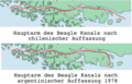
From 1881 to 1890, both Chile and Argentina recognized all the islands south of Tierra del Fuego as Chilean territory. But by 1904 a new interpretation of the term “Beagle Channel” prevailed in Argentina. According to its proponents, the channel turned south at Punta Navarro around the island of Navarino and the Instituto Geográfico Argentino (predecessor of the Instituto Geográfico Militar Argentino ) renamed the easternmost part of the Beagle Channel the Moat Channel . After unsuccessful negotiations, an arbitration decision was sought from an international tribunal , which in May 1977 ruled in favor of Chile (see Beagle Channel Arbitration between the Republic of Argentina and the Republic of Chile , Report and Decision of the Court of Arbitration). Despite its self-imposed obligation to accept the judgment, Argentina refused to consent and threatened Chile with war .
Article 5
«El Estrecho de Magallanes queda neutralizado a perpetuidad y asegurada su libre navegación para las banderas de todas las naciones. En el interés de asegurar esta libertad y neutralidad, no se construirán en las costas fortificaciones ni defensas militares que puedan contrariar ese propósito. »
“The Strait of Magellan will be neutralized forever and free passage guaranteed for ships of all nations. In the interests of guaranteeing this freedom and neutrality, neither fortresses nor military defenses will be built on the coasts that could contradict this purpose. "
Chile had already promised free navigation and neutrality in the Strait of Magellan in a diplomatic note to the largest seafaring nations in 1873. Great Britain and the United States exerted influence in the run-up to the negotiations through the latter's ambassadors in Santiago de Chile and Buenos Aires.
When applying Article 5, there were differences about the meaning of "Strait of Magellan": Chile claimed that it was a (only) direct waterway between the Pacific and Atlantic, Argentina, however, that all canals in the region were international waterways. With the Argentine recognition of the Chilean baselines , these were resolved in 1984 in favor of Chile.
The status of the border at the eastern mouth of the Strait of Magellan was also undefined: Chile claimed to be bordering the Atlantic, which Argentina not only denied, but Argentina, as bordering the Strait of Magellan, saw itself as entitled to participate in the regulation of shipping. In the friendship and peace treaty of 1984 , both countries waived any claims beyond their respective borders.
Article 6
«Los gobiernos de la República Argentina y de Chile ejercerán pleno dominio a perpetuidad sobre los territorios que respectivamente les pertenecen según el presente arreglo. Toda cuestión que, por desgracia, surgiere entre ambos países, ya sea con motivo de esta transacción, ya sea de cualquier otra causa, será sometida al fallo de una potencia amiga, quedando en todo caso como límite inconmovible entre las dos repeats elemovible expresa en el presente arreglo. »
“The governments of the Republic of Argentina and Chile will forever exercise full control over the respective territories that belong to them under this agreement. Any dispute that regrettably should arise between the two countries, either because of this settlement or for any other cause, will be subjected to the judgment of a friendly power, in which case the border between the two republics remains unchangeable as set out in this agreement. "
Article 6 is very important historically. He declares all previous border treaties null and void, which means that the uti possidetis doctrine should no longer apply.
- The problems
In 1904 Argentina changed its understanding of the Beagle Channel course

Two definitions of the east mouth of the Strait of Magellan
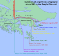
9 Argentine interpretations of the treaty in the Beagle Channel zone
Chilean (black) and Argentine (yellow) understanding of the Strait of Magellan


The contract in literature
Shortly after it was signed, the contract found its way into world literature through the socially critical novel Die Schiffwüchigen der "Jonathan" by Jules Verne from 1897. In 1907 the novel was revised by his son Michel Verne and published in 1907 posthumously.
In the novel, the contract ends the last possibility of being able to live in the world without state tutelage. A European, Kaw-djer, lives on the island of Nueva , "Without God and Without Lord", in peaceful coexistence with the Indians until the news of the new treaty reaches the residents:
- - "Is the news sure true?"
- - "Yes" answered the Indian ...
- - "And all the islands south of the Beagle Channel," asked the Kaw-djer, "now belong to Chile?"
- - "All"
- - "Also the Isla Nueva!"
- - "Yes"
- - "It must have turned out like this," said the Kwa-djer, and his voice trembled from the intense inner excitement.
analysis
The treaty eased relations and reduced conflicts to a minimum. The disputes over the valleys south of the 40th parallel were more numerous and more difficult than expected, but the zone is difficult to survey and a better criterion was not available.
In Argentina it is often complained that Articles 2 and 3 are ambiguous and that no map is attached to the contract. The fact is that Argentina's reasoning has been refuted in the arbitration tribunal in the Beagle conflict and two proposals by the Pope kept Chile's interpretation of the treaty. "The Impact of International Law on International Cooperation: Theoretical Perspectives" comes up with a succinct judgment about the Argentine legal opportunities:
"From a legal and juridical point of view, the Argentine rights over the Beagle Channel islands could not be sustained."
"From a legal and legal point of view, one could not justify the Argentine rights over the Beagle Channel."
Author Michael Morris speculates in The Strait of Magellan about other reasons for the Argentine reasoning:
"Rearguard Argentine efforts has been made to gain recognition for some kind of shared management regime for the strait, in order to mitigate what was perceived as the striking diplomatic defeat for Argentina in the 1881 treaty granting Chile control over the strait."
“Subsequent efforts have been made by the Argentine side to gain recognition of joint jurisdiction over the Strait of Magellan, thus alleviating what was perceived as Argentina's distinctive diplomatic defeat in the Treaty of 1881, namely to give Chile control of the Strait of Magellan "
Since each party was now convinced of the legitimacy of their rights, the demands (and successes) of the other side were felt on both sides of the Andes as a usurpation of their own rights, which had disastrous consequences for the understanding of the two nations.
See also
Web links
- British arbitration award from 1977: Beagle channel conflict: Report and decision of the Court of Arbitration (PDF; 4.9 MB), in English. It contains several documents, including the 1881 Border Treaty.
- British award from 1902: The Cordillera of the Andes Boundary Case Argentina, Chile (PDF; 273 kB), in English
- Historia de las Relaciones Exteriores Argentinas Chapters 32 to 34, in Spanish
- Karin Oellers-Frahm: The arbitration award in the Beagle Channel dispute (PDF; 1.8 MB), reports and documents: Max Planck Institute for Comparative Public Law and International Law.
Individual evidence
- ↑ Jules Verne: The castaways of the Jonathan . Pawlak Taschenbuch Verlag, Berlin 1984, ISBN 3-8224-1096-9 , p. 17.
-
↑ Michael Morris. In: The Strait of Magellan . Martinus Nijhoff Publisher, 1989, ISBN 0-7923-0181-1 , p. 22 ff .:
"An 1837 French expedition of Dumont D'Urville surveyed navigational conditions in the Strait of Magellan and recommended that a French colony be established at the strait to support future traffic along the route."
-
↑ The Argentine participation in the pact had already been decided by the Argentine "Cámara de Diputados de la Nación Argentina", but was withheld by the Senate because there were also border disputes with Bolivia and also because Chile had a much larger navy, see La misión Balmaceda : asegurar la neutralidad argentina en la guerra del Pacífico :
- "Esta aprensión argentina hacía la superioridad naval de su vecino allende los Andes, derivada por cierto de consideraciones de equilibrio de poder, inhibió a las autoridades de Buenos Aires de actuar contra Chile aliándose a Perú y Bolivia."
- Translation: "This Argentine concern about the superiority of the maritime force of its neighbor on the other side of the Andes, derived from equilibrium considerations, prevented the government in Buenos Aires from acting against Chile by entering into an alliance with Peru and Bolivia."
- ^ Francesco Francioni: International Law for Antarctica. Martinus Nijhoff Publishers, 1996, ISBN 978-90-411-0364-2 , p. 652 ( limited preview in Google book search).
-
↑ See Las negociaciones Barros Arana-Irigoyen
- "Sus instrucciones lo autorizaban a perseguir un acuerdo final en la cuestión limítrofe y le otorgaban margins de maniobra para obtener dos objetivos cruciales para la posición chilena: la posesión del estrecho de Magallanes más suficiente territorio para defender dicha vía."
- Translation: "His powers empowered him to seek a definitive compromise on the border issue and they gave him leeway to achieve two crucial goals of the Chilean position: possession of the Strait of Magellan and sufficient territory to defend this waterway."
-
^ According to Aníbal Pinto Garmendia , President of Chile at the time of the negotiations
- "Ningún hombre sensato de Chile pretendía la Patagonia"
- Translation: "No reasonable Chilean wants Patagonia"
-
↑ See § 31 arbitration award from 1977: Beagle channel conflict: Report and decision of the Court of Arbitration ( Memento of April 10, 2008 in the Internet Archive ) (PDF; 4.9 MB), in English:
- "... [Patagonia] was the price she [Chile] had to pay for obtaining in return the exclusive control of the Straits and of the whole Magellanic region. … It is on this basis, as well as on the actual attribution of Patagonian territory to Argentina effected by Article II of the Treaty, that the Court reaches the conclusion that it was the antithesis Patagonia / Magellan, rather than Magellan / Atlantic, which constituted the fundamental element of the treaty settlement. ... "
-
↑ See "The Strait of Magellan", Michael Morris, Martinus Nijhoff Publishers, ISBN 0-7923-0181-1 , page 54:
- ... since these [maritime] boundaries were considered relatively unimportant and strictly a function of the delineation of the land boundaries.
-
↑ See Erik Brüel, International Straits, Vol. II, Sweet and Maxwell, Ltd., London, England, 1947, p225. Cited in Michael A. Morris, "The Strait of Magellan" , Martinus Nijhoff Publishers, ISBN 0-7923-0181-1 , page 65:
- "The Government of the United States will not tolerate exclusive claims by any nation whatsoever to the Straits of Magellan, and will hold responsible any Government that undertakes, no matter on what pretext, to lay or impost or check on United States commerce through the Straits . " .
- ↑ Reanudación de las Negociaciones entre la Argentina y Chile por elconflicto limítrofe. In: argentina-rree.com. Retrieved January 9, 2015 (Spanish).
-
↑ See Elertrado del 23 de julio de 1881 :
- “Ambrosio Montt criticó the step by contrario a los intereses de Chile. Además de señalar la imposibilidad de trazar el límite como lo establecía el artículo 1 °, porque no había coincidencia absoluta entre las más altas cumbres y la divisoria de aguas, ... "
- Translation: “[MP] Ambrosio Montt criticized the treaty because it ran counter to the interests of Chile. Not only that the border could not be drawn, as provided in Article 1, because there was no absolute correspondence between the highest mountains and the watershed, ... "
- ↑ The documents are written and signed in Spanish and apart from the order in which the contract signatories are named, they are identical. The award of 1977 (Beagle Channel) ( memento of April 10, 2008 in the Internet Archive ) (PDF; 4.9 MB) on page 84 contains an English translation presented by Chile and the award of 1902 (Cordillera) (PDF; 341 kB) on page 45 contains an English translation of the contract published in Argentina. The English translations are not legally binding and they have relevant differences from one another.
- ↑ a b c d e Eltretado del 23 de julio de 1881. In: argentina-rree.com. Retrieved January 9, 2015 (Spanish).
- ^ Reports of International Arbitral Awards . tape IX . UN , November 20, 1902, The Cordillera of the Andes Boundary Case (Argentina, Chile) , pp. 37–49 (English, un.org [PDF; 267 kB ; accessed on September 24, 2018]).
-
↑ See Elertrado de límites con Chile , accessed April 24, 2009:
«De acuerdo con una serie de fuentes, la actitud de la clase política argentina parece haber coincidido, entre 1881 y 1902, con la interpretación del treadado de 1881 que tienen los chilenos y que luego adoptarían la Corte Arbitral y el Papa en la cuestión del Beagle. In otras palabras, que la intención de los signatarios del ttedado de 1881 fue la de otorgar las islas a Chile. Entre estos testimonios, cabe citar el hecho de que el 'Mapa Oficial de la República Argentina', confeccionado en 1882 bajo el auspicio de Bernardo de Irigoyen, en ese entonces ministro del interior, atribuía las islas Picton, Lennox y Nueva a Chile. "
“A number of sources agree that the attitude of the Argentine political class in the interpretation of the Treaty of 1881 was the same between 1881 and 1902 as the Chileans and how it was later adopted by the arbitration tribunal and the Pope on the Beagle question became. In other words, that the signatories of the 1881 treaty intended to award the islands to Chile. Among these testimonies, one should mention the fact that the 'Mapa Oficial de la República Argentina', created in 1882 under the auspices of Bernardo de Irigoyen, then Minister of the Interior, included the islands of Picton, Lennox and Nueva Chile. "
- ↑ Reports Of Internationalarbitral Awards ( English ) United Nations. Archived from the original on April 10, 2008. Retrieved April 25, 2019.
- ^ Michael A. Morris: The Strait of Magellan , Martinus Nijhoff Publishers, 1988, ISBN 0-7923-0181-1 , pp. 68, 104
- ↑ See El carácter ambiguo del texto delertrado de 1881
- ↑ Eyal Benvenisti: The Impact of International Law on International Cooperation . Cambridge University Press, 2004, ISBN 978-1-139-45606-7 ( limited preview in Google Book Search).
- ↑ Michael A. Morris: The Strait of Magellan . Martinus Nijhoff Publishers, 1989, ISBN 978-0-7923-0181-3 ( limited preview in Google book search).