Groote Eylandt
| Groote Eylandt | ||
|---|---|---|
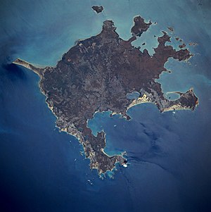
| Groote Eylandt satellite image | ||
| Waters | Gulf of Carpentaria | |
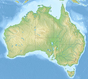
| Geographical location | 14 ° 0 ′ S , 136 ° 36 ′ E | |
|
|
||
| length | 60 km | |
| width | 50 km | |
| surface | 2 260 km² | |
| Highest elevation | Central Hill 219 m |
|
| Residents | 1539 (2007) <1 inh / km² |
|
| main place | Angurugu | |
Groote Eylandt (outdated Dutch spelling for Big Island ) is the fourth largest island in Australia and the largest island in the Gulf of Carpentaria on the north coast of Australia.
One of the largest manganese ore deposits on earth is mined on Groote Eylandt .
The island off the north coast of Australia is inhabited and administered by the Aborigines of the Anindilyakwa . There are four Aboriginal settlements in the archipelago : Angurugu , Umbakumba and Alyangula on Groote Eylandt and Milyakburra on Bickerton Island . Groote Eylandt belongs together with Bickerton Island to the Local Government Area East Arnhem Region in Arnhem Land in the Northern Territory .
location and size
Groote Eylandt is about 600 kilometers east of Darwin . The shortest distance to mainland Australia is 42.9 kilometers. The island measures 68.8 kilometers from east to west and 73.2 kilometers from north to south with an area of about 2260 km².
In addition to the larger islands of Bickerton Island and Winchelsea Island , the Groote Island group includes around 40 smaller islands, including Connexion Island , Hawk Island , Arruwa Island , Hawknest Island , North Point Island and Burney Island .
history
Aboriginal
The Anindilyakwa lived on Groote Eylandt long before the European settlement. The island is not only of great cultural and spiritual importance for them, but also for Aborigines on the mainland about 50 kilometers away.
They are traditional hunters and gatherers. In this dream time there are huge lizards, snakes and reptiles that live in water holes. The highest point on the island, the 219 meter high Central Hill, which the Aborigines call Yandarrnga, has a special meaning in their imaginations because it migrated there from the mainland and brought various plants and animals with it.
The culture of the Anindilyakwa was influenced by the Macassar fishermen in the 18th and 19th centuries . On the occasion of the American-Australian Scientific Expedition to Arnhem Land , which took place in 1948 , 2400 rock art motifs were documented at the three key discovery sites on the islands of Chasm Island, Angoroko and Junduruna. The extensive documentation made it possible to understand how the motifs changed over time. This method was new and trend-setting for all further field research into Aboriginal art .
European history
A first European settlement emerged on the Emerald River in 1921 when the Church Missionary Society built the Emerald River Mission . It was an Aboriginal mission station eight miles south of Angurugu that moved to Angurugu after World War II . In 1938, Umbakumba was a site for Qantas flying boats and for sea cucumber fishing.
In 1943, the Royal Australian Air Force built a runway at Angurugu for military aircraft used in the Pacific War.
In 1948 Groote Eylandt was one of the three camp sites of the 17-person American-Australian Scientific Expedition to Arnhem Land in Arnhem Land, which examined and documented the way of life and culture of the Aborigines on the island for 14 weeks.
With the coming into force of the Aboriginal Land Rights (Northern Territory) Act 1976 in December 1977 the Aborigines were granted the land rights. In 2006 the island areas were declared to be Anindilyakwa Indigenous Protected Area , which extends over an area of 2312 km².
landscape
The landscape of Groote Eylandt consists of extensive lateritic plains, rocky plateaus and hills in the central and southern areas and large dune fields and sand plains in the coastal regions. The mining of one of the largest manganese ore deposits on earth by GEMCo ( Groote Eylandt Mining Company Pty Ltd. ) near Angurugu represents an extensive intervention in nature on Groote Eylandt .
The smaller, flat islands mostly consist of sand and corals, some with sandstone or granite cliffs, or they are just rocky cliffs.
Flora and fauna
900 plant and 330 vertebrate species have been counted on the archipelago.
Five animal and 42 plant species are endemic there. The endemic blind snake Rhamphotyphlops minimus is also found on Groote Island. Seven wild animal species occur. Animals on the island are, for example, the northern jumping mouse , the short-eared rock kangaroo and the spiny-tailed monitor .
Four species of sea turtles nest on the islands : the green sea turtle , olive ridged turtle , hawksbill sea turtle and barrier reef turtle .
There are 9,800 hectares of dry rainforest on the island . Tree savannahs from Darwin Stringybark and Woollybutt span large parts of the island.
economy
Near the Aboriginal settlement of Angurugu, GEMCO , a joint venture between Anglo American (40 percent) and BHP Billiton (60 percent), is a manganese ore mining company that dominates the island's economy. According to the information provided by this company in 2011, it is the largest and cheapest mining of this ore on earth. GEMCO also announced that it will invest AUD 254 million to increase ore production from 4.2 to 4.8 million tonnes to allow for 5.9 million tonnes of annual extraction after improving road haulage and port loading capacity .
There is also an airport on the island served by Airnorth , Alliance Airlines and Vincent Aviation .
Economic activities are also created for a developing tourism, so recently the Dugong Beach Resort , several clinics and a cultural center, the Aindilyakwa Arts and Cultural Center .
Personalities
- David Warren (1925-2010) the inventor of the flight recorder was born on Groote Eylandt.
Web links
Individual evidence
- ↑ eastarnhem.nt.gov.au : Umbakumba , in English, accessed January 24, 2012
- ^ Martin Thomas, Margo Neale: Exploring the Legacy of the 1948 Arnhem Land Expedition. Australian National University, Griffin Press, 2011, ISBN 978-1-921666-44-5 , pp. 135-136. online on googlebooks
- ↑ eastarnhem.nt.gov.au : Umbakumba , in English, accessed January 24, 2012
- ↑ eastarnhem.nt.gov.au : Angurugu , in English, accessed January 24, 2013
- ↑ a b c nretas.nt.gov.au ( Memento of the original from March 25, 2012 in the Internet Archive ) Info: The archive link was inserted automatically and has not yet been checked. Please check the original and archive link according to the instructions and then remove this notice. (PDF; 595 kB): Groote Eylands Group , in English, accessed on January 25, 2013
- ↑ abc.net.au : Eric Tlozek: Mine giant expands Top End manganese operation , July 29, 2011, in English, accessed on January 27, 2013

