
Grunbach (Remshalden)
|
Grunbach
Remshalden municipality
|
|
|---|---|
 |
|
| Height : | 241 (235-300) m |
| Area : | 4.73 km² |
| Residents : | 6337 (2016) |
| Population density : | 1,340 inhabitants / km² |
| Incorporation : | 1st October 1974 |
| Postal code : | 73630 |
| Area code : | 07151 |
Grunbach is a district of the municipality of Remshalden in the Rems-Murr district in Baden-Württemberg . The district has around 6000 inhabitants (as of 2007)
Geographical location
Grunbach lies on both sides of the river flowing westwards here on the bank, on the valley floor and on the slopes of the lower Rems valley , which is below 235 m above sea level. NHN leaves the district. The highest point of the predominantly right-wing demarcation in the far north on the upper wooded slope of the Buocher Höhe reaches over 471 m above sea level. NHN , its eastern edge follows the course of the Zehntbach , the western part that of the Gundelsbach . The eponymous Grunbach runs through the old town center from this small plateau . The upper edge of the building now reaches almost 300 m above sea level. NHN , the old church on the right Grunbach slope stands at 271 m above sea level. NHN , large parts of the newer local development are also in the fairly flat right Remsaue at heights of 240 m above sea level. NHN . To the left of the river there is an industrial area in the floodplain and above it a smaller residential area of recent times on the slope.
General

In the village center on the northern slope of the Rems valley with the church, several old half-timbered houses have been preserved, including the “Hirsch” inn from 1610, the oldest inn in the Rems valley. This town center, together with numerous surrounding new development areas, forms today's district of Grunbach-Nord .
In the early 1950s, the new housing estate on the southern slope of the Rems, the district of Grunbach-Süd , arose because of the strong need for building space (including for ethnic Germans ) . This is why the locals like to call it a settlement . There is also the Catholic Church “St. Michael". Until she moved to Geradstetten at the end of the 2016/2017 school year, the "Ernst Heinkel Realschule" was located here.
In the village and afterwards two road bridges connect the two districts. Between the two there are commercial and industrial facilities in the valley floor along the railway, the Rems and the federal highway 29 .
Furthermore, there are 2 emigrant farms belonging to Grunbach.
history

The place "Conronbach" was first mentioned in 1142 when a "Conradus de Conronbach" was mentioned in a document from April 22nd, 1142. "Grunbach", in which a pleban is mentioned in 1238 , was probably created in the more recent expansion period. The Backnang Abbey (1245), the “von Urbach” (until 1425) and the Schorndorf and Göppingen hospitals were wealthy here . Local nobility is only assured for the 12th century. In 1293, Württemberg took over the protection of the Grunbach estates of the Lorch Monastery against the granting of Vogt law .
There is evidence of a wine press as early as 1328, and the winemaking tradition can be proven by a large number of documents. It can also be read from the three former wine presses in Schillerstrasse.
Grunbach belonged to the Württemberg office or Oberamt Schorndorf and came to the Waiblingen district when it was repealed in 1938 . In 1861, with the opening of the Remsbahn , Grunbach got a connection to the rail network of the Württemberg Railway . In 1939 Grunbach was classified as a "commercial community and service center".
On January 1, 1972, Buoch, located above Grunbach, was incorporated into Grunbach. On October 1, 1974, the towns of Geradstetten and Grunbach were finally merged to form today's municipality of Remshalden.
Attractions
Dionysius Church

The landmark of Grunbach is the Protestant parish church completed in 1481, a fortified church originally consecrated to Saint Dionysius (1451) and later to Veranus (1537).
As a choir side tower church, it was built in 1481 in place of a previous church, which probably came from the 12th century. In 1863 this church was corrected and changed by Christian Friedrich von Leins (including windows and choir arch). The eight-sided spire is still late Gothic.
The choir has a 3/8 choir closure and is vaulted with a single rib star. The nave of the nave has a wooden barrel vault from 1964. The sandstone pulpit is from the beginning of the 17th century; its sound cover around 1720. The crucifix is an excellent carving from the early 16th century from the circle of Hans Seyfer . A Romanesque font dates from around 1200. In the choir is the tomb for Johannes Lins, priest from Winnenden (d. 1517), with the figure of the deceased in low relief. The lead glass windows in the choir are by Wolf-Dieter Kohler from 1964. In the nave there are two windows by Hans Gottfried von Stockhausen from 1999.
The church is integrated into a fortified church architecture . The stone church structure is surrounded by a circular wall, which has strong supporting pillars on the east and south sides because of the sloping terrain. The three-story tower has loopholes. In the southern wall there are two stone crosses (presumably atonement crosses ) with a chiseled winegrower's knife ("Horbe") and a medieval local arrest (the so-called "Karrasperle").
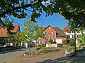
Church square with church fountain

Church fountain

Carbead

Stone crosses in the church wall

Old town hall on the church square


Local museum
In the former fire station of Grunbach in the Schillerstraße below the Protestant church there is a local history museum, which is looked after by the Museumverein Remshalden eV. A cross-section of the economic history of Remshalden as well as the history of the aircraft pioneer Ernst Heinkel, who was born here, can be seen under the themes of Heimat, Wirtschaft, Heinkel .
The museum is open every Sunday from 2 p.m. to 5 p.m., for groups at any time by appointment. Admission is free.
Grunbach waterfall

Above the village of Grunbach, the Grunbach brook falls a little north of a sports field, three meters deep in the forest, over a Keupersandstone bank.
Personalities
- Gottfried Seibold, local poet, honorary citizen
- Ernst Heinkel (1888–1958), aircraft designer, honorary citizen
- David Wolleber (around 1555–1597), chronicler
literature
- The Rems-Murr district . Konrad Theiss Verlag, Stuttgart 1980, ISBN 3-8062-0243-5 .
Web links
Individual evidence
- ↑ http://www.remstal-route.de/Remshalden.371.0.html Retrieved on November 7, 2012.
- ↑ Wirtemberg Document Book; ed. from the Royal State Archives in Stuttgart on archive.org. Retrieved November 7, 2012
- ^ A b Landesarchivdirektion Baden-Württemberg (ed.): The state of Baden-Württemberg, official description by districts and communities. Verlag W. Kohlhammer, Stuttgart 1978, Volume III, p. 539
- ^ Landesarchivdirektion Baden-Württemberg (ed.): The state of Baden-Württemberg, official description by districts and communities. Verlag W. Kohlhammer, Stuttgart 1978, Volume III, p. 537
- ^ Federal Statistical Office (ed.): Historical municipality directory for the Federal Republic of Germany. Name, border and key number changes in municipalities, counties and administrative districts from May 27, 1970 to December 31, 1982 . W. Kohlhammer, Stuttgart / Mainz 1983, ISBN 3-17-003263-1 , p. 459 .
- ^ Federal Statistical Office (ed.): Historical municipality directory for the Federal Republic of Germany. Name, border and key number changes in municipalities, counties and administrative districts from May 27, 1970 to December 31, 1982 . W. Kohlhammer, Stuttgart / Mainz 1983, ISBN 3-17-003263-1 , p. 464 .
- ↑ http://www.museumsvereinremshalden.de/
- ↑ Hiking brochure (PDF; 8.7 MB). Retrieved January 29, 2014.