Grunewald (Waldbröl)
|
Grunewald
City of Waldbröl
Coordinates: 50 ° 51 ′ 5 " N , 7 ° 35 ′ 39" E
|
|
|---|---|
| Height : | 300 m above sea level NN |
| Residents : | 5 (Dec 2, 2004) |
| Postal code : | 51545 |
| Area code : | 02291 |
|
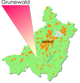
Location of Grunewald in Waldbröl
|
|
Grunewald is a village in the urban area of the town of Waldbröl in the Oberbergischer Kreis in southern North Rhine-Westphalia , Germany , within the administrative district of Cologne .
Location and description
The place is about 3.9 km south of the city center.
history
First mention
The place was first mentioned in a document in 1850 .
Spelling of the first mention: Grunewald
leisure
Hiking and biking trails
The A3 hiking trail leads through Grunewald, coming from Spurkenbach .
Bus and train connections
Public bus
Stop: Grunewald
- 342 Waldbröl, Windeck-Schladern ( OVAG )
swell
- ↑ Gottfried Corbach: History of Waldbröl. Scriba-Verlag, Cologne 1973, ISBN 3-921232-03-1 , pp. 499-538.

