Guadalupito district
| Guadalupito district | |
|---|---|
 The district of Guadalupito is located in the southwest of the province of Virú (marked in red) |
|
| Basic data | |
| Country | Peru |
| region | La Libertad |
| province | Viru |
| Seat | Guadalupito |
| surface | 404.7 km² |
| Residents | 7075 (2017) |
| density | 17 inhabitants per km² |
| founding | 4th January 1995 |
| ISO 3166-2 | PE-LAL |
| Website | www.mdg.gob.pe (Spanish) |
| politics | |
| Alcalde District | Roberto Rafael Oliva Paredes (2019-2022) |
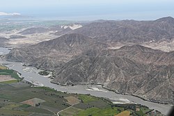
| Lower reaches of the Río Santa; the right bank is in the Guadalupito district | |
Coordinates: 8 ° 57 ′ S , 78 ° 37 ′ W
The district of Guadalupito is located in the province of Virú in the La Libertad region in northwestern Peru . It has an area of 404.72 km². The 2017 census counted 7,075 inhabitants. Ten years earlier the population was 6232. With the establishment of the province of Virú on January 4, 1995, the newly founded district of Guadalupito was separated from the existing district of Virú . The administrative seat is in the small town of Guadalupito, 23 m high near the mouth of the Río Santa , with 1950 inhabitants (as of 2017).
Geographical location
The district of Guadalupito is located in the southwest of the province of Virú. It stretches from the Pacific coast over the arid coastal plain of Peru to the first foothills of the Peruvian Western Cordillera . The district has about 36 km of coastline and extends up to 19 km inland. Irrigated agriculture is only practiced along the Río Santa. Otherwise there is desert vegetation. The national road 1N ( Panamericana ) from Chimbote to Trujillo crosses the district. In the north the district borders on the district Chao , in the east and southeast on the district Chimbote ( province Santa ) and in the south on the district Santa (also province Santa).
Web links
- Municipalidad de Guadalupito
- Peru: Region La Libertad (provinces and districts) at www.citypopulation.de
- INEI Perú
