Good noise
|
Good noise
Coordinates: 51 ° 54 ′ 44 ″ N , 10 ° 33 ′ 7 ″ E
|
|
|---|---|
| Height : | 200 (193-207) m above sea level NN |
| Postal code : | 38667 |
| Area code : | 05322 |
|
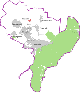
Location Gut Radaus in Bad Harzburg
|
|
|
Gut Radau from a western perspective, 2017
|
|
Gut Radau is a farming community with around 15 houses and an estate that belongs to the town of Bad Harzburg in the Goslar district and is named after the Radau river , which flows past the town to the north in a northerly direction. In administrative terms, Gut Radau belongs to the northeastern district of Bettingerode .
history
The history of the Radau estate is closely related to the Güdecke (= "Gütischen", from the estate ), a series of fields that arose from the reclamation of the Harlingeröder quarry. The Harlingeröder Bruch or Herlingeröder Brook was a wetland that stretched from the eastern edge of the Langenberg to the Goslar-Halberstädtische Heerstrasse north of Gut Radau and formed the eastern border of the districts between Harlingerode , Bettingerode and Schlewecke . It was first mentioned in a document in 1251; thereafter, Count Heinrich the Elder of Wöltingerode gives the Goslar cathedral monastery the forest for a fee. This was a trade that was used to cover travel expenses in the Third Crusade . The complete transfer of the break to the cathedral monastery took place in 1281.
The eastern part of the quarry was cleared by around 1350. However, a calculation shows that not all hooves have stayed with Harlingerode. The Radau estate has existed since at least the late Middle Ages, and its existence has been assured since 1386. A ducal "Schap-Hof" is named for 1484, which in the 16th century became the Lower Administrative Office of the Harzburg Office . The name "Neuenhof" is also attested on a map from 1659. The estate was privatized in 1860 and from then on bore the name Gut Radau.
During the Second World War , Polish slave laborers were used on the Radau estate.
In the early 1970s, the four-lane federal highway 4 was built immediately to the east of Gut Radau, which was upgraded to federal freeway 395 (today: federal freeway 369 ) on January 1, 1975 . In this context, the old federal road 4 , on which the Radau estate was located, was downgraded to a municipal road. By 1982 the hamlet was finally cut off from the south with the construction of the Bad Harzburg triangle and the four-lane federal road 6 , only a bridge has since connected the estate with Mathildenhütte .
In 2004 the Bündheim monastery founded the "Harzland GbR ", whose farm was set up in Gut Radau.
geography
To the north of Gut Radau there is an alluvial forest with about a dozen ponds, which extend along the Radau in a north-south direction for two and a half kilometers and reach a width of up to two hundred meters. A few hundred meters west of Gut Radau is the Bad Harzburg-Nord industrial park .
The place is divided into two parts: The southern main domain Gut Radau is located in a depression east of the Radau, which is directly adjacent to the Bad Harzburg triangle . To the southeast of the ponds on the K 40, the Radaumühle lies between the Radau and a right tributary, the Hüttenbach.
Neighboring places
Information as the crow flies from the town center:
- Radauanger - 0.75 km west-southwest
- Westerode - 1.2 km southeast
- Schlewecke - 1.5 km south-southwest
- Bettingerode - 1.5 km east-northeast
- Harlingerode - 2 km west-southwest
Transport links
The A 369 runs immediately to the east ; its southern end, the Bad Harzburg triangle , encircles Gut Radau in the east and south and serves as a connection point to the federal highways 4 and 6 .
The location can be reached from the south via a junction of the K 30. Another signposted driveway from the north branches off from the K 46 between Harlingerode in the west and Bettingerode in the east, to which the Bundesstraße 6 is also connected.
Personalities
- Hermann Henrich Meier (1809–1898) resided here
- Friedrich-Gustav Bernhard (1888–1945) was born here
gallery
Web links
literature
- Alfred Breustedt: 950 years of Harlingerode. 1053-2003. (Ortschronik) Harlingerode 2003, OCLC 249318716 . Pp. 13-16.
Individual evidence
- ^ History of the noble families in the free imperial city of Augsburg . 1762, p. 72.
- ↑ see file: Landkarte_Ducatus_Brunsvicensis_fereq (ue) _Lunaeburgensis.jpg
- ^ Goslarsche Zeitung : Lecture on forced labor in Bad Harzburg . February 16, 2019, accessed February 18, 2019.
- ^ Klostergut BündheimBad Harzburg on klostergut-buendheim.de , accessed on September 13, 2017.


