
Bouncy
| Bouncy | ||
|---|---|---|
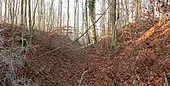
 The outgoing spur of the Knollenberg with the Hüburg, in the background the Hube ridge |
||
| Creation time : | 10th century | |
| Castle type : | Hilltop castle | |
| Conservation status: | Wall and foundation remains | |
| Standing position : | unknown | |
| Construction: | Wall-trench system, mortared dry stone wall | |
| Geographical location | 51 ° 50 '58.4 " N , 9 ° 57' 9.7" E | |
|
||


The Hüburg is an abandoned castle between Greene and Ippensen , today both part of the city of Einbeck in Lower Saxony . It is considered the forerunner of Castle Greene, built in 1308 .
location
The fortifications on the Ippenser district were built on a northern spur-like foothill of the Knollenberg as part of the Hube ridge at an altitude of about 140 to 165 m above sea level. NN built and can be viewed as a spur castle . It is up to 65 meters above the Leine running east in the valley . The castle complex takes up part of the ridge and is naturally protected by steep slopes to the north, east and west. In this way, it uses the favorable fortification terrain of a mountain foothill that extends into the Leine valley.
history
An Ottonian castle complex is assumed . Otto II donated the Greene ban to Gandersheim Monastery in 980 . This assumes that the castle must have already existed. 1039 confirmed Heinrich III. the pen the possession of the castrum greene . There are no further documentary reports. Finds from the 1970s to 1990s show settlement from the 10th to the 12th century, which has not yet been archaeologically verified.
Two construction phases can be seen. First the elevation was fortified by two ramparts on the unsecured side facing south. The inner wall was included in the construction of a later, surrounding, almost rectangular fortification.
The Brunswick City Director Wilhelm Bode made a site plan of the fortification in 1824, on which he called it Hühnenburg . This was an earlier popular name for ramparts of an unknown time, from which today's name Hüburg is derived.
description
The bouncy castle, which is now under the deciduous forest, was 190 meters long and 60 to 80 meters wide. It was about 1.2 hectares in size. It is divided into a larger, almost square north area of 80 × 80 meters and a narrower south area of 60 × 80 meters.
Building remains exist on the edge of the terrain on the east side through a 190 meter long wall foundation made of red sandstone mortared. The edge wall probably consisted of two-shell masonry. The north side is secured by a flat stone wall up to seven meters wide. The structure of the west side cannot be reliably reconstructed due to erosion and artificial terrain overprint. It was probably also secured by a wall.
The flat south side is secured by two section bars with a ditch and wall. The outer wall is 80 meters long and 1.5 meters high with a width of 12 to 14 meters. To the outside there is a 10 meter wide and 1.5 meter deep trench. The wall has a modern breakthrough. The inner wall is 120 meters long and runs part of the slope. The wall is 15 meters wide and three meters high. Remnants of the foundation of a defensive wall can be found on it. The difference in height between the inner wall and the bottom of the trench is five meters today and could previously have been up to 10 meters with an existing defensive wall. The wall breakthrough for a forest path is modern.
A building 25 meters long and 14 meters wide stands out in the interior through a raised floor. There are also remains of a 15 × 10 meter building. Six funnel-shaped pits with a diameter of 10 meters and an artificial elevation point to other building structures. A wall-like elevation of 10 meters wide crossing the interior could be an older section wall.
A retracted gate with overlapping ends was on the west side. The gate had a three to five meter wide and up to ten meter long gate lane.

View from the inner wall to the moat
The inner moat, on the right the inner wall

The outer moat, on the right the outer wall

View from the inside of the facility to the earlier access on the west side


Found objects

In the 1980s, the then Göttingen district archaeologist Klaus Grote discovered a fire-colored cultural layer on the castle area after Windbruch , from which numerous finds from a medieval castle settlement originate. These include over 200 ceramic fragments from spherical pots , approx. 300 animal bones, a shard of a clay crucible , three iron objects (with a presumably arrowhead ), a turquoise glass bead, a piece of smooth lime plaster and a chunk of fire clay .
classification
The finds suggest that the fortifications existed between the 10th and 12th centuries. The archaeologist Alfred Tode interpreted the Hüburg in 1958 as a Franconian military station in the system of the Franconian- Carolingian development of the southern Saxon region in the early Middle Ages . In 1987 the archaeologist Klaus Grote considered this classification to be obsolete in terms of research history. He sees the Hüburg aligned with the Greene Castle, which is about a kilometer to the north, and Greene, which was already mentioned in 980, as the central location of the Greenegau and the central Leinebergland . The Hüburg was in the area of influence of the Gandersheim Abbey, about six kilometers away. It could have been a smaller imperial castle built on the Liudolfingian- Ttonian initiative. Nevertheless keeps Grote it due to terrain findings possible that the Hüburg arose as early as 800 in the Franco-Saxon conflict and further expansion, had approximately the function as Henry castle . Grote rates the Hüburg as one of the most interesting and promising castle complexes in southern Saxony.
literature
- Klaus Grote : The bailey at Greene. An early to high medieval castle complex in the middle of the Leinetal in: Nachrichten aus Niedersachsens Urgeschichte 56 (1987), pp. 175–194.
- Margarethe Zimmermann, Hans Kensche: Burgen und Schlösser im Hildesheimer Land , Lax-Verlag, Hildesheim 2001 (2nd edition), ISBN 978-3-82696-280-6 , p. 55.
- Markus C. Blaich , Sonja Stadje, Kim Kappes: Hüburg in: Die Heldenburg bei Salzderhelden, castle and residence in the Principality of Grubenhagen , (= guide to the prehistory and early history of Lower Saxony. 32) Isensee Verlag , Oldenburg 2019, pp. 99-101.
Web links
- Entry by Gudrun Pischke zu Hüburg in the scientific database " EBIDAT " of the European Castle Institute
- Greene, District Northeim. Bouncy. on Klaus Grote's private website