Hürbe
| Hürbe | ||
|
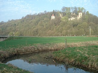
The Hürbe a few steps before the mouth of the Lone. View upstream to the west of the Kaltenburg ruins . |
||
| Data | ||
| Water code | DE : 11724 | |
| location | Germany , Baden-Wuerttemberg , Swabian Alb | |
| River system | Danube | |
| Drain over | Brenz → Danube → Black Sea | |
| source | In Hürben 48 ° 35 ′ 37 ″ N , 10 ° 12 ′ 16 ″ E |
|
| Source height | approx. 455 m above sea level NN | |
| Spring discharge |
MQ |
60 l / s |
| muzzle | south of Hermaringen in the Brenz coordinates: 48 ° 35 ′ 18 ″ N , 10 ° 10 ′ 1 ″ E 48 ° 35 ′ 18 ″ N , 10 ° 10 ′ 1 ″ E |
|
| Mouth height | 445.6 m above sea level NN | |
| Height difference | approx. 9.4 m | |
| Bottom slope | approx. 1.3 ‰ | |
| length | 7.2 km | |
| Catchment area | 9.778 km² excluding Lone | |
| Right tributaries | Lone | |
The Hürbe is a seven kilometer long right tributary of the Brenz on the Swabian Alb in the district of Heidenheim .
Surname
The name Hürbe is derived from the Old High German word horo or from the Middle High German word hurwin , which means something like swamp or morass . The Urbrenz, which once flowed through the Hürbetal in a loop stretching far to the west around the Kagberg , and the Hürbener See , which was finally drained in the 19th century , created this wetland.
geography
Hoop pot
The Hürbetopf, also called Roßwedde , is located at the foot of the Hohen Felsen in Hürben, on which Hürben Castle once stood. It is a dammed karst spring that pours an average of 60 liters per second .
course
Only a few meters after its source, the Hürbe is reinforced by the Häuselbach, which flows out on the left. The Hürbe then flows through Hürben in a southeastern direction . In the further course it is strongly straightened. Below the Kaltenburg ruin , narrow meadow meanders set in in the Hinterer See Gewann and small spring outlets flow towards the creek barely more than a meter wide above. Then, once leads after 2 km flow path from the right with well 37 km considerably longer, but despite a more than thirty times as large catchment area to the southwest in the ver karsteten Alb often less water Lone .
The Hürbe flows from here in an approximately east-northeast direction and passes the southern edge of the Burgberg , opposite which the Burgberg Castle stands above the right-hand slope. Then the bottom of the valley widens to the left to the wide plain of the Lower Ried , a formerly marshy area that some ditches drain towards it. It narrows again between the Hermaringener Hirschberg and the mountain spur of the Ravensburg ruins , here the Hürbe crosses under the Brenzbahn at the very last . Then it flows into the Brenz from the right a few hundred meters southwest of the outskirts of Hermaringen .
Tributaries
- Häuselbach (left)
- Lone (right) , 38 km and 310.2 km²
history
The Lone Valley, known for its caves and prehistoric finds, flows south of Hürben . The site of the Hürbe estuary was previously called St. Josen-Furt and in the Middle Ages was the north-western border point of the Duchy of Bavaria .
Attractions
- Charlottenhöhle
- Gussenburg Castle
- Kaltenburg Castle
- Neighboring Eselsburger valley with rock formation Steinerne Jungfrauen
- Adjacent Lone Valley with several caves
Web links
- Run and catchment area (without Lone) of the Hürbe on: State Institute for the Environment Baden-Württemberg (LUBW) ( information )
-
The upper hurdle with hiking and cycling trails on: Geoportal Baden-Württemberg ( information )
For the lower section of the route, please move the map section.

