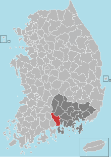
Hadong
| Hadong-gun | |||
|---|---|---|---|
| Korean alphabet : | 하동군 | ||
| Chinese characters : | 河東 郡 | ||
| Revised Romanization : | Hadong-gun | ||
| McCune-Reischauer : | Hadong-kun | ||
| Basic data | |||
| Province : | Gyeongsangnam-do | ||
| Coordinates : | 35 ° 4 ′ N , 127 ° 45 ′ E | ||
| Surface: | 675 km² | ||
| Residents: | 47,099 (as of: 2019) | ||
| Population density : | 70 inhabitants per km² | ||
| Structure: | 1 eup, 12 myeon | ||
| map | |||
|
|||
Hadong County ( Korean : 하동군 , Hadong-gun ) is located in Gyeongsangnam-do Province . The administrative headquarters are in Hadong-eup City. The district had an area of 675 km² and a population of 47,099 inhabitants in 2019.
Hadong County was called Dasachon (place with a lot of sand) when it was part of Jin State. He later became part of Nangnoguk, one of 12 states in the Byeonhan Confederation . It was called Handasa-gun during the Three Kingdoms and was renamed Hadong-gun in 757 during the reign of King Gyeongdeok .
Hadong is considered a rural area. While much of Korea has seen unprecedented expansion in industrial development, Hadong remains a popular destination for those looking to get away from the hustle and bustle of city life. However, due to the lack of activity in the industrial sector, the government had hardly received any incentive to expand the sometimes inadequate road infrastructure.
Known for its green tea, Hadong hosts an annual green tea festival in May and June. Hadong's popularity as a tourist destination continues to grow every year, and the local government plays an active role in attracting visitors

