
Miryang
| Miryang | ||||
|---|---|---|---|---|
| Korean alphabet : | 밀양시 | |||
| Chinese characters : | 密 陽 市 | |||
| Revised Romanization : | Miryang-si | |||
| McCune-Reischauer : | Miryang-si | |||
| Basic data | ||||
| Province : | Gyeongsangnam-do | |||
| Coordinates : | 35 ° 30 ' N , 128 ° 45' E | |||
| Surface: | 799.01 km² | |||
| Residents: | 108,342 (as of 2013) | |||
| Population density : | 136 inhabitants per km² | |||
| Structure: | 2 Eup, 9 Myeon, 5 Dong | |||
| map | ||||
|
||||

Miryang is a large city in Gyeongsangnam-do Province in South Korea . Miryang was declared a city in 1989.
Miryang is known through the traditional folk tune Miryang Arirang . There are also some historical buildings there, such as the Yeongnamnu Pavilion , which dates back to the 12th century and was rebuilt in 1844 . Other attractions include the natural cooling grotto Eoreumgol and the Buddhist temple Pyochungsa . The neo-Confucian scholar Kim Jong-jik of the 15th century is among the famous people of the place . The Yerim Seowon dedicated to him , a combinatorial shrine and academy site from the 16th century, is located in Miryang. The 16th century Buddhist monk Yu Jeong (Samyeong-daesa) also comes from Miryang.
More recently, the city has become known as the location or location of Korean films such as Mutt Boy (2003) and Secret Sunshine (2007).
Geography and traffic
Miryang is roughly in the middle of the two major cities Daegu and Busan . With the Expressway 55 and the opening of the Korea Train Express station, the city is connected to the major transport network in South Korea. Because of its location surrounded by cities, the city was already a traditional transport hub in the southeast region during the modernization period of South Korea. Miryang is 34.3 km from Changwon , 77.1 km from Ulsan , 79.1 km from Busan and 85.4 km from Daegu.
Miryang borders the Ulju counties in the city of Ulsan and Cheongdo in Gyeongsangbuk-do Province . The city is embedded in a mountain region in three directions, except for the south, where the area around the Nakdonggang River forms a flat landscape to the south. This area is mainly used as a cultivation area for wet rice.
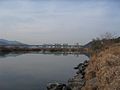
View of the city from the Miryanggang river

Miryang's conventional station for general trains
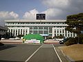
The new town house of Miryang

Chimnyugak on the west wing of Yeongnamnu

Miryang Arirang Monument


Town twinning
-
 Yasugi , Japan (since 1990)
 -
Ōmihachiman , Japan (since 1994)
-
 Benxi , People's Republic of China (since 1998)
 -
 Namwon , South Korea (since 1999)
 -
Ulanhot , People's Republic of China (since 1999)
-
 New Milford , United States (since 2004)
 -
Handan , People's Republic of China (since 2004)
-
Setouchi , Japan (since 2006)
sons and daughters of the town
- Kim Gi-jung (* 1990), badminton player
- Kim Ki-eung (* 1990), badminton player
Web links
- Official website (English)
Individual evidence
- ↑ Yeongnamnu Pavilion (Miryang) (밀양 영남루) on Visit Korea , accessed April 1, 2014 (English).
- ↑ Pyochungsa Temple (표충사) on Visit Korea , accessed April 1, 2014 (English).