Hagener Hut
| Hagener Hütte DAV hut category I |
||
|---|---|---|
|
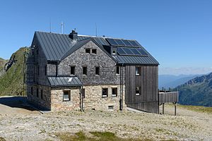
The Hagener Hütte from the northwest |
||
| Mountain range | Goldberg Group | |
| Geographical location: | 47 ° 1 '39 " N , 13 ° 5' 22" E | |
| Altitude | 2446 m above sea level A. | |
|
|
||
| owner | Section Hagen of the DAV | |
| Built | 1911/12, 1999 | |
| Construction type | hut | |
| Usual opening times | Beginning of July to mid-September, in winter also on weekends (depending on the weather) | |
| accommodation | 14 beds, 28 camps | |
| Winter room | 4 bearings | |
| Web link | Website at the section | |
| Hut directory | ÖAV DAV | |

The Hagener Hütte is located at 2,446 m above sea level. A. Höhe in the Hohe Tauern between the Goldberg and Ankogel groups in the eastern part of the Hohe Tauern National Park in the state of Carinthia , Austria. The hut is located on the Mallnitzer Tauern , which marks the transition between the Mallnitzer Tauerntal (Carinthia) and the Gasteiner Naßfeld ( Salzburg ). It is owned by the Hagen section of the German Alpine Club .
history
The site of the hut is at the apex of an old mule track, which, however, was no longer of economic importance at the time of construction due to the expansion of other pass roads and the Tauern Railway. In June 1911 the construction of the Hagener Hütte began, in August 1912 the house was finished. It was built above the old Tauernhaus with a view of the Goldberg and Ankogel groups.
The ground floor is made of broken limestone; the outer walls are 70 cm thick. The upper and attic storeys, which consist of a wooden structure, are protected against wind and weather by double air insulation, clad on the outside with wooden shingles and connected to the ground floor masonry by strong anchors.
In 1999 and the following years, the hut was expanded and modernized. It received an environmentally friendly, biological sewage system, a new water supply and a photovoltaic system that generates electricity from sunlight.
Accesses
- from Sportgastein ( 1575 m ) through Nassfeld, walking time: 3 hours
- from Mallnitz from the Jamnig Alm car park ( 1730 m ), walking time: 2½ hours
- from Böckstein ( 1127 m ), walking time: 4½ hours
- from Mallnitz from town center ( 1190 m ), walking time: 4 hours
Tour possibilities
Transitions to neighboring huts
- Mindener Hut ( 2428 m , self-catering hut ), walking time: 3 hours
- Hannoverhaus ( 2565 m ) via the Mindener Hut and Korntauern ( 2476 m ), medium difficulty, walking time: 6 hours
- Duisburger Hütte ( 2572 m ) via Feldseescharte (2712 m), walking time: 5 hours
The Austrian long-distance hiking trails Zentralalpenweg and Rupertiweg cross at the Hagener Hütte . The hut is also a stage destination on the Tauernhöhenweg .
Mountaineering
- Vorderer Geißlkopf ( 2974 m ), medium difficulty, walking time: 2½ hours
- Romatenspitze ( 2695 m ), medium difficulty, walking time: 2 hours
Ski touring
- Mallnitz (Jamnig Alm)
- Passage to Duisburger Hütte
- Anterior Geißlkopf (only for experienced)
- Tomato top
Literature & Maps
- Walter Mair: Hiking guide Glockner region. , Bergverlag Rother , Munich 2008, ISBN 978-3-7633-4317-1
Web links
Individual evidence
- ↑ limited preview in the Google book search
- ↑ Tauernhöhenweg. DAV & ÖAV , accessed on September 22, 2018 .

