
Hammersbach (Loisach)
| Hammersbach | ||
 The Hammersbach catchment area |
||
| Data | ||
| Water code | DE : 16232 | |
| location | District of Garmisch-Partenkirchen , Upper Bavaria , Bavaria , Germany | |
| River system | Danube | |
| Drain over | Loisach → Isar → Danube → Black Sea | |
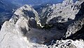
| origin | Höllentalferner 47 ° 25 ′ 37 ″ N , 10 ° 59 ′ 56 ″ E |
|
| Source height | 2200 m above sea level NN | |
| muzzle | in the Loisach near Grainau Coordinates: 47 ° 28 '45 " N , 11 ° 3' 8" E 47 ° 28 '45 " N , 11 ° 3' 8" E |
|
| Mouth height | 722 m | |
| Height difference | 1478 m | |
| Bottom slope | 21% | |
| length | 7 km | |
| Communities | Grainau | |
 Hammersbach in Hammersbach , passing under the Bavarian Zugspitzbahn |
||
The Hammersbach is a 7 km long right tributary of the Loisach . Together with the Krepbach, which flows into the Hammersbach in the Schmölz district of Grainau , it drains the northwesternmost part of the Wetterstein Mountains , i.e. H. the northern flanks of the Zugspitze and the Waxenstein , as well as the Höllental . The Hammersbach itself arises from the melt waters of the Höllentalferner and flows through the Höllentalkar and then falls as a waterfall over the so-called “board” into the Höllental. There it flows through the Höllentalklamm and Maximiliansklamm. As soon as the Hammersbach leaves the Wetterstein Limestone area and enters the Partnach strata , the valley becomes wider and wooded. In the Grainau district of Hammersbach , the Hammersbach enters the approx. 2 km wide valley floor of the Loisach and finally flows into the Loisach in Schmölz, near the western entrance to Garmisch-Partenkirchen .
The most important and longest tributary of the Hammersbach is the Krepbach , which flows orographically from the left almost 300 m before it flows into the Loisach.
More photos
View from the Zugspitze into the Höllental
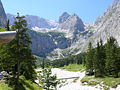
Hammersbach im Höllental, view from the Höllentalangerhütte towards the head of the valley

Hammersbach approx. 500 m before the Grainau district of the same name

The Hammersbach flows into the Loisach


