Harland (St. Pölten)
|
|||
| Basic data | |||
| Surface: | 4.75 km² | ||
| Residents: | 1,796 (December 31, 2015) | ||
| Population density: | 378 inhabitants per km² | ||
| Height: | 244 m above sea level A. | ||
| Post Code: | 3100 | ||
| Geographical location: | 48 ° 9 ' N , 15 ° 38' E | ||
| Cadastral communities | |||
|
|||
| Location in St. Pölten | |||

|
|||
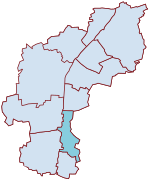
Harland is located in Lower Austria on the Traisen and has been a district of St. Pölten since its incorporation in 1939 . The districts of Ochsenburg , Spratzern , St. Georgen and Stattersdorf border on Harland, and in the east the village borders on Pyhra .
Names
The names of the three cadastral communities have different origins. While the name Harland refers to the cultivation of flax , Altmannsdorf probably goes back to the Bishop Altmann von Passau . There are various theories about windpassing. On the one hand there is a reference to winds , i.e. Slavs, or, according to more recent research, to a settlement in the area of Windbruch .
history
Settlement in prehistoric times can be proven by grave finds. Altmannsdorf is first mentioned in a document in 1091, the first documents about Harland come from the 13th century. The 66 residents at that time were mainly active as farmers. From 1364 Pyhra is documented as a local parish.
The originally agricultural village grew in the 19th century with the opening of the Mathias Salcher & Sons thread factory . This was accompanied by housing projects to accommodate the migrant workers. In the years after 1899 the Traisen was regulated, this created additional jobs.
The first school was built by the Salcher brothers in 1883, and in 1909 the entire village was supplied with electricity and a sewer. From 1911 the St. Pölten tram operated in Harland. In 1923 the place had 1,361 inhabitants.
In 1939, all three cadastral parishes were reunified from Pyhra to St. Pölten, Altmannsdorf and Windpassing were reunified to St. Georgen in 1955. The reintegration of the two cadastral communities took place in 1971 together with St. Georgen and Ochsenburg. Harland received its own church in 1966, which together with Stattersdorf forms a parish.
The Mathias Salcher & Sons company in 1883
politics
As the cadastral community of St. Pölten, Harland does not have its own local council.
See also: St. Pölten: Politics
Sports
The oldest football club in St. Pölten, the Harlander Sportclub, plays its home games on the sports field in Harland. It was founded in 1912 as the workers' sports club of the Harlander Zwirnfabrik and also offers weightlifting, tennis and ice stock sport.
Public facilities
In Harland there is a secondary and elementary school and a kindergarten.
Culture and sights
- Harland Romanian Orthodox Branch Church


