
Government district (St. Pölten)
| Regierungsviertel (location component ) | |||
|---|---|---|---|
|
|||
| Basic data | |||
| Pole. District , state | St. Pölten (city) (P), Lower Austria | ||
| Judicial district | St. Polten | ||
| Pole. local community | St. Pölten ( KG St. Pölten ) | ||
| Locality | St. Polten | ||
| district | St. Polten | ||
| Coordinates | 48 ° 11 '59 " N , 15 ° 37' 54" E | ||
| height | 270 m above sea level A. | ||
| Post Code | 3107 St. Pölten | ||
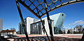
 East side of the government district on the Traisen : Landhaussteg, the Lower Austria Landhaus, in the background the Klangturm |
|||
| Source: STAT : index of places ; BEV : GEONAM ; NÖGIS | |||

The area of the newly built regional administration in St. Pölten is called the government quarter (also known as the country house quarter ) .
geography
The government district is located east of the old town, directly on the Traisen . It stretches between the river in the east, Wiener Strasse (with Wienerbrücke, B1 ), Rennbahnstrasse (B1), Siegfried Ludwig-Platz and Niederösterreich-Ring (B1a, with Julius Raab Bridge). There is also a separate bridge in between over the Traisen, the Landhaussteg .
| Traisen settlement | ||
|
St. Pölten old town |
.svg)
|
Rainersiedlung (Stt. Oberwagram ) |
| Shooting range |
history
In 1986 St. Pölten became the capital of Lower Austria . Therefore, the state government with the office of the Lower Austrian state government should move here from the Herrengasse in Vienna . The Austrian architect Ernst Hoffmann emerged as the winner of an international architectural competition. In 1992 the groundbreaking took place under Governor Siegfried Ludwig .
The entire complex, which houses the state government, was built in five years in the undeveloped area of the city's banks of the Traisen. In 1997 the building was finished so that the entire administration could move.
On the banks of the Traisen is the state parliament building , which, according to its shape, is called the ship . The 80 m high sound tower rises behind it . Directly connected to the area is the cultural district of St. Poelten where the Festspielhaus St. Pölten , an exhibition hall of Hans Hollein , and the National Museum are housed.
View from the state museum to the festival hall

Provincial Museum of Lower Austria

Sound tower

State Archives and State Library


literature
- Hermann Riepl, Lower Austrian Capital Planning Company: The Lower Austrian Capital: Vision and Reality: Documentation. Verlag Niederösterreichische Landeshauptstadt-Planungsgesellschaft mbH, 1987, ISBN 978-3-85326-820-9 .
- Walter Zschokke, Otto Kapfinger, ORTE Architecture Network Lower Austria: Architecture in Lower Austria, 1986–1997. Verlag Birkhäuser, 1997, ISBN 978-3-7643-5746-7 .
Web links
- St. Pölten - The new government district , aeiou Austria Lexicon (Fig.)

Districts (municipality structure) : Harland | Ochsenburg | Pottenbrunn | Radlberg | Ratzersdorf | Spatter | St. Georgen am Steinfelde | St. Pölten | Stattersdorf | Viehofen | Wagram
Cadastral communities and localities: Altmannsdorf | Dörfl (KG Dörfl near Ochsenburg ) | Eggendorf | Ganzendorf | Hafing | Harland | Hard | Kreisberg | Matzersdorf | Mill passage | Nadelbach | Oberradlberg | Oberwagram | Ober-Zwischenbrunn (KG Ober Zwischenbrunn ) | Ochsenburg | Pengersdorf | Pottenbrunn | Pummersdorf | Ragelsdorf | Ratzersdorf an der Traisen | Reitzersdorf | Schwadorf | Spatter | St. Georgen am Steinfelde | St. Pölten | Stattersdorf | Steinfeld | Teufelhof | Unterradlberg | Unterwagram | Under interim Brunn (KG under interim Brunn ) | Viehofen | Völtendorf | Waitzendorf | Moated castle | Next | Wetzersdorf | Windpassing | Witzendorf | Wolfenberg | Wörth | Zwerndorf
City districts (settlement identification) :
Am Pittnerberg •
Iceberg settlement
•
Hubert Schnofl settlement • Kupferbrunn •
Oberwagram •
St. Pölten •
Spratzern •
Stattersdorf •
Teufelhof •
Unterwagram •
Viehofen •
Waldsiedlung
Villages:
Alt-Hart •
Altmannsdorf •
Eggendorf •
Ganzendorf •
Harland •
Mühlgang •
Nadelbach •
Oberradlberg •
Ober-Zwischenbrunn •
Ochsenburg •
Pengersdorf •
Pottenbrunn •
Pummersdorf •
Ragelsdorf •
Ratzersdorf an der Traisen •
Schwadorf •
St. Georgen am Steinfelde •
Steinfeld •
Unter-Zwischenbrunn •
Unterradlberg •
Völtendorf •
Waitzendorf •
Wasserburg •
Weitern •
Windpassing •
Witzendorf •
Zwerndorf |
Hamlet:
Dörfl •
Hafing •
Kreisberg •
Mooshöfe •
Wetzersdorf •
Wolfenberg |
Rotten:
Matzersdorf •
Wörth |
Settlements:
Neu-Hart •
Bahnhofsiedlung |
Group of houses:
Freizeitgelände Ratzersdorf |
Other local documents:
Brewery •
Feldmühle •
Castle Ochsenburg •
Spanplattenwerk •
Government District •
Reitzersdorf •
Prater •
Trauttmansdorff •
Traisenausiedlung •
INDIGO settlement •
Waitzendorf settlement •
castle rental
Counting districts / districts: Old Town | Zentr.Wohn-u.Erholungsgeb | Younger residential areas I | Younger residential areas II | Mixed housing and other funct .: Eisberg-Siedlung • Werkstättensprengel • Schwaighof-Nord • Spratzern-Mitte • Spratzern-Ost - Harland • Daniel Gran-Schulsprengel • Glanzstoffsprengel • Viehofen • Schwaighof-Süd | Mixed-use residential-other radio: Kasernensprengel • Pernerstorferpl. - Hell. • Hospital district | Mainly settlement areas: Handel-Mazzetti-Straße • Oberwagram-Nord • Wagram-Ost • Hubert Schnofl-Siedlung • Traisenausiedlung • Kupferbrunn - Prater • Oberwagram-Süd • Unterwagram-Nordwest • Ertlstraße | Rural peripheral areas: Upper and Lower Radlberg • Ragelsdorf - Weitern • Waitzendorf - Witzendorf | Mixed peripheral areas: Spratzern-West • Stattersdorf | Pottenbrunn : Pottenbrunn market • Pottenbrunn area | Ratzersdorf | St.Georgen am Steinfelde : St.Georgen central area • Hart - Wörth • St.Georgen area | Pummersdorf | Altmannsdorf
Former communities: Viehofen 1848–1922 | Spratzern 1850–1922 | Radlberg 1850–1939 | Stattersdorf 1850–1939 | Ratzersdorf 1850–1939, 1955–1971 | Ragelsdorf 1923–1969 | Pottenbrunn 1850–1971 | Sankt Georgen 1850–1971