
Stattersdorf
|
|||
| Basic data | |||
| Surface: | 4.91 km² | ||
| Residents: | 1,973 (December 31, 2015) | ||
| Population density: | 402 inhabitants per km² | ||
| Height: | 244 m above sea level A. | ||
| Post Code: | 3100 | ||
| Geographical location: | 48 ° 11 ' N , 15 ° 38' E | ||
| Cadastral communities | |||
|
Stattersdorf |
|||
| Location in St. Pölten | |||

|
|||
|
|
|||


Stattersdorf is located in Lower Austria on the east side of the Traisen between Harland and Wagram . The place has been a district of St. Pölten since its incorporation in 1939 , before it formed the municipality of Stattersdorf with the districts of Unter- and Oberwagram.
The districts Spratzern , Harland, St. Pölten and Wagram border on Stattersdorf, and in the east the town borders on Pyhra .
history
Evidence of a settlement before 1072, in which Stattersdorf is mentioned for the first time as Staudratisdorf , is missing.
During the first Turkish siege in 1529, a large part of the properties was destroyed because, unlike St. Pölten, where many of the residents fled to, Stattersdorf did not have a city wall. Even during the second Turkish siege in 1683, the Stattersdorfer sought protection in St. Pölten.
In 1785 the parish was separated from Pyhra and assigned to the Franciscans in St. Pölten, and in 1803 the first diapering school for small children was founded. The bigger ones were sent to St. Pölten or Pyhra. In 1850, together with the localities of Oberwagram and Unterwagram, the community of Stattersdorf was formed, and the chapel in its current form was built in 1856.
The school was built in its current location in 1870. At that time it was financed entirely by Harlander Coats , as most of the students were children of employees. In 1890 the school was expanded.
The first attempt at incorporation into St. Pölten was started in 1920, at that time only 6 out of 502 residents who were entitled to vote were in favor. The districts of Ober- and Unterwagram, however, were incorporated into St. Pölten. In 1927 a cinema was opened in the newly built parish hall .
After the German troops marched in in 1938, the construction of the Reichsautobahn , today's A1 , began in the local area of Stattersdorf. In the following year, Stattersdorf was dissolved as a community and incorporated into St. Pölten. After the withdrawal of the Red Army in 1955, a vote was taken as to whether Stattersdorf should be reunited, which the population denied.
In 1961 the construction of the water pipeline began, and in 1971 the construction of the canals.
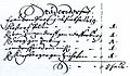
A land register entry from 1591

The chapel built in 1857


politics
As the cadastral municipality of St. Pölten, Stattersdorf does not have its own municipal council; the mayors before 1939 are on the list of mayors of St. Pölten .
economy
Established businesses
The Salzer company , which emerged from the Stattersdorfer paper mill in 1798 , a branch of the Sunpor company , a Billa and Konrad Blumen are located in the district .
Restaurants
In addition to the restaurants Gasthaus Mario Lindtner (formerly: Augustin) and WirZhaus Zum Gwercher , both of which have been offering traditional home cooking since 2019, Stattersdorf owns the Restaurant Pizzeria Kem .
Public facilities
There is an elementary school and a kindergarten in Stattersdorf.
Culture and sights

Lilienhof
The Lilienhof developed between the 16th century and the 20th century . The extensive complex essentially consists of the octagonal chapel, the baroque Schlössl , the Mary Ward House and a farm building.
Already in the Middle Ages the court was mentioned as belonging to the Canon Monastery. Since 1755 in the possession of the Institute of the English Misses, who use the Mary Ward House as a boarding school.
Web links
Individual evidence
- ↑ Magistrate of the City of St. Pölten: Annual Statistical Report 2015.
- ↑ Start: Branch Finder - BILLA. In: billa.at. Retrieved May 24, 2019 .
- ↑ Gasthaus Mario Lindtner. In: gasthaus-lindtner.at. Retrieved May 24, 2019 .
- ↑ Home. In: gwercher.at. Retrieved May 24, 2019 .
- ^ Pizzeria Kem. In: pizzeria-kem.business.site. Retrieved May 24, 2019 .
Districts (municipality structure) : Harland | Ochsenburg | Pottenbrunn | Radlberg | Ratzersdorf | Spatter | St. Georgen am Steinfelde | St. Pölten | Stattersdorf | Viehofen | Wagram
Cadastral communities and localities: Altmannsdorf | Dörfl (KG Dörfl near Ochsenburg ) | Eggendorf | Ganzendorf | Hafing | Harland | Hard | Kreisberg | Matzersdorf | Mill passage | Nadelbach | Oberradlberg | Oberwagram | Ober-Zwischenbrunn (KG Ober Zwischenbrunn ) | Ochsenburg | Pengersdorf | Pottenbrunn | Pummersdorf | Ragelsdorf | Ratzersdorf an der Traisen | Reitzersdorf | Schwadorf | Spatter | St. Georgen am Steinfelde | St. Pölten | Stattersdorf | Steinfeld | Teufelhof | Unterradlberg | Unterwagram | Under interim Brunn (KG under interim Brunn ) | Viehofen | Völtendorf | Waitzendorf | Moated castle | Next | Wetzersdorf | Windpassing | Witzendorf | Wolfenberg | Wörth | Zwerndorf
City districts (settlement identification) :
Am Pittnerberg •
Iceberg settlement
•
Hubert Schnofl settlement • Kupferbrunn •
Oberwagram •
St. Pölten •
Spratzern •
Stattersdorf •
Teufelhof •
Unterwagram •
Viehofen •
Waldsiedlung
Villages:
Alt-Hart •
Altmannsdorf •
Eggendorf •
Ganzendorf •
Harland •
Mühlgang •
Nadelbach •
Oberradlberg •
Ober-Zwischenbrunn •
Ochsenburg •
Pengersdorf •
Pottenbrunn •
Pummersdorf •
Ragelsdorf •
Ratzersdorf an der Traisen •
Schwadorf •
St. Georgen am Steinfelde •
Steinfeld •
Unter-Zwischenbrunn •
Unterradlberg •
Völtendorf •
Waitzendorf •
Wasserburg •
Weitern •
Windpassing •
Witzendorf •
Zwerndorf |
Hamlet:
Dörfl •
Hafing •
Kreisberg •
Mooshöfe •
Wetzersdorf •
Wolfenberg |
Rotten:
Matzersdorf •
Wörth |
Settlements:
Neu-Hart •
Bahnhofsiedlung |
Group of houses:
Freizeitgelände Ratzersdorf |
Other local documents:
Brewery •
Feldmühle •
Castle Ochsenburg •
Spanplattenwerk •
Government District •
Reitzersdorf •
Prater •
Trauttmansdorff •
Traisenausiedlung •
INDIGO settlement •
Waitzendorf settlement •
castle rental
Counting districts / districts: Old Town | Zentr.Wohn-u.Erholungsgeb | Younger residential areas I | Younger residential areas II | Mixed housing and other funct .: Eisberg-Siedlung • Werkstättensprengel • Schwaighof-Nord • Spratzern-Mitte • Spratzern-Ost - Harland • Daniel Gran-Schulsprengel • Glanzstoffsprengel • Viehofen • Schwaighof-Süd | Mixed-use residential-other radio: Kasernensprengel • Pernerstorferpl. - Hell. • Hospital district | Mainly settlement areas: Handel-Mazzetti-Straße • Oberwagram-Nord • Wagram-Ost • Hubert Schnofl-Siedlung • Traisenausiedlung • Kupferbrunn - Prater • Oberwagram-Süd • Unterwagram-Nordwest • Ertlstraße | Rural peripheral areas: Upper and Lower Radlberg • Ragelsdorf - Weitern • Waitzendorf - Witzendorf | Mixed peripheral areas: Spratzern-West • Stattersdorf | Pottenbrunn : Pottenbrunn market • Pottenbrunn area | Ratzersdorf | St.Georgen am Steinfelde : St.Georgen central area • Hart - Wörth • St.Georgen area | Pummersdorf | Altmannsdorf
Former communities: Viehofen 1848–1922 | Spratzern 1850–1922 | Radlberg 1850–1939 | Stattersdorf 1850–1939 | Ratzersdorf 1850–1939, 1955–1971 | Ragelsdorf 1923–1969 | Pottenbrunn 1850–1971 | Sankt Georgen 1850–1971