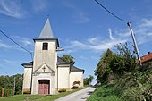
Waitzendorf (municipality of St. Pölten)
|
Waitzendorf (D) locality cadastral community Waitzendorf |
||
|---|---|---|
|
|
||
| Basic data | ||
| Pole. District , state | St. Pölten (city) (P), Lower Austria | |
| Judicial district | St. Polten | |
| Pole. local community | St. Polten | |
| district | St. Polten | |
| Coordinates | 48 ° 13 '19 " N , 15 ° 35' 35" E | |
| height | 275 m above sea level A. | |
| Residents of the village | 334 (January 1, 2020) | |
| Building status | 165 (approx., Addresses 2018 ) | |
| Area d. KG | 3.43 km² | |
| Post Code | 3100 St. Pölten | |
| Statistical identification | ||
| Locality code | 03166 | |
| Cadastral parish number | 19600 | |
| Counting district / district | Waitzendorf- Witzendorf (30201 072) | |
| Source: STAT : index of places ; BEV : GEONAM ; NÖGIS ; | ||
Waitzendorf is a place in the Mostviertel in Lower Austria , and a locality and cadastral municipality of the municipality and statutory city of St. Pölten . It belongs to the St. Pölten district .
geography
The village of Waitzendorf is located in the rural area on the city limits, about 3 kilometers northwest of the city center . It is located on the Pielach-Traisen-Platte , the threshold west of the city, at around 275 m above sea level. A. Höhe, and extends at the Waitzendorfer Graben on the upper Moosbach , which already drains to the Pielach . The town can be reached from the center via Goldegger Straße (L 5122). The Westbahn runs south . The village consists of about 60 buildings.
The village of Waitzendorf includes around 170 addresses with around 330 inhabitants. This also includes the Waitzendorf settlement south-east towards the city. The cadastral area extends between the city limits and the main cemetery. In the north it is enough to the Kalbling ( 343 m above sea level ) and to the outskirts of Wernersdorf .
Farmland extends around the place, in the north the fox forest .
| Wernersdorf (O and KG, Gem.Neidling , District St. Pölten-Land ) | ||

|
Am Pittnerberg (O and KG St. Pölten )
|
|
| Mooshöfe (O and KG Witzendorf ) |
Witzendorf (O and KG)
|
St. Pölten (O and KG)
|
- ∗ Ortschaft / KG Pultendorf is not directly adjacent because Afing meets Wernersdorf here.
History and sights
The place is already 1189 as Wazendorf (personal name + -dorf demonstrably) had 16 houses in 1248, and was owned by the Canons . From the creation of the local congregations in 1848/49 , he belonged to the community of Mamau . This was dissolved in 1969, the majority came to Karlstetten, Waitzendorf was incorporated into St. Pölten like Witzendorf.
The local chapel of St. Florian was built in 1833 and is a listed building .
There is still an old cellar lane in the village , called "At the church" (Wittgensteinstrasse; see also the list of cellar lanes in St. Pölten ).
In St. Pölten there are long-term plans for a western tangent that should connect the Kremser Landesstraße ( L100 ) between Weitern and Viehofen with the possible junction of Linzer Straße (B1, Wiener Straße ) to the planned Traisental Schnellstraße (S34). This tangent would run between Waitzendorf and Waitzendorf settlement.
Individual evidence
- 30201 - St. Pölten. Community data, Statistics Austria .
- ↑ a b Register census from October 31, 2011 - population by location: Municipality: St. Pölten (30201). Statistics Austria (pdf).
- ^ Karl Gutkas: St. Pölten. Series Niederösterreichischer Kulturführer , Verlag Jugend und Volk, 1984, p. 51
-
^ Kurt Klein (edit.): Historical local dictionary . Statistical documentation on population and settlement history. Ed .: Vienna Institute of Demography [VID] d. Austrian Academy of Sciences . Lower Austria Part 1, St. Pölten: Waitzendorf , p.
15 ( online document , explanations . Suppl . ; both PDF - oD [updated]). Special sources: 1248: Anton Victor Felgel (Ed.): Document book of the Canon Monastery of St. Pölten , 1885.
- ↑ Karl Gutkas (Ed.): Becoming and essence of the city of S [ank] t Pölten. 4th edition, Verlag Niederösterreichisches Pressehaus, 1980, p. 19.
-
↑ cf. Eduard Matzenauer: Nieder-Österreichischer Gemeinde-Schematismus (with the exception of the Gross-Commune Wien) with statistical-topographical notes for the electoral period 1861–1863: a handbook for everyone,… Verlag Gerold, 1862, p. 163 ( digitized, Google, complete View );
also ops. cit. Gutkas 1980, p. 10. - ^ Division of the Mamau community. Implementation ordinance for the Lower Austrian municipal code, LGBl 446/1968.
- ↑ William Rausch (HSGB.), Hermann Rafetseder (ed.): Territorial and name changes of the municipalities in Austria since the mid-19th century. Volume 2 of the Austrian Working Group for Urban History Research , Ludwig Boltzmann Institute for Urban History Research : Research on the history of cities and markets in Austria. Linz 1989, ISBN 3-900387-22-2 , Ragelsdorf , p. 242 f.
- ^ Road construction in St. Pölten: The next Traisen bridge for the state capital is being planned. In: Niederösterreichische Nachrichten online (noen.at), February 2, 2017.


