Heinersdorf (Schwedt / Oder)
Location of Heinersdorf in Brandenburg |
Heinersdorf is with 695 inhabitants (December 31, 2006) on a municipal area of 24.43 km² a district of the city of Schwedt / Oder in the Uckermark district in Brandenburg .
geography
Heinersdorf lies on the edge of the Welse- Urstromtal, about six kilometers northwest of the Schwedt city center. To the west and south of Heinersdorf, wide fields determine the landscape, to the north and east the Kavelheide forest area, which is around 20 km² in size, spreads out.
history
1313 Heinersdorf was first mentioned as Henricksdorf in the copy book of the Marienwalde monastery in Neumark . The name probably comes from a locator named Heinrich .
After disputes over property in the border area with Pomerania, Heinersdorf finally came to the Mark Brandenburg in 1472 . The Heinersdorfer Gutshof often changes hands. The two knight seats in the village were ceded to the city of Schwedt in 1624.
During the Thirty Years' War , as in the entire Uckermark , there was arson and looting in Heinersdorf, and even the church burned down.
Potato cultivation in Heinersdorf is documented for the first time in 1740. Around this time, tobacco cultivation also came to the eastern Uckermark.
In 1781 the village was hit by a dysentery epidemic and in 1849 by cholera ; Typhus broke out in 1865 .
On the Angermünde-Schwedt railway line, built in 1873, the Heinersdorf station building was erected in 1888 on the road to Berkholz . The Heinersdorf Volunteer Fire Brigade was founded in 1924.
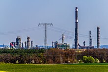
After the Second World War , the large estates were expropriated and the land was distributed to new farmers. 90 farms (including 50 new farms) cultivated an agricultural area of 1,400 hectares. In 1960 the collectivization of agriculture was completed with the formation of two LPGs . In the forest area one kilometer northeast of Heinersdorf, the Schwedt oil processing plant (today's PCK Raffinerie GmbH ) was built in 1958 , and in 1965 the oil tank farm of today's Schwedt Mineralölverbundleitung GmbH was built south of Heinersdorf . During this time, the station was very busy, mainly building materials were unloaded here.
In 1969 there was a consumer department store, a kindergarten and a crèche in Heinersdorf. The HO restaurant “Heinersdorfer Krug” in the center of the village closed in 1990. On January 1, 1974, the community of Heinersdorf was incorporated into the Schwedt district and until 1993 was the only district in Schwedt.
The church was renovated from 1982 to 1987 and an organ was installed. The financing was taken over exclusively by Heinersdorfer citizens. After the political upheaval in 1989/1990, the parish hall and the listed rectory from the 18th century were reconstructed and a new fire station was inaugurated in 1998 . The castle-like office building , built in 1794/1795 according to plans by the Swedish master builder Georg Wilhelm Berlischky , was demolished in January 2004 after it had been empty since 1990.

Population development
- 1774-268
- 1964-770
- 1974-620
- 2006 - 695
Regular events
The dance in May , the sports festival in summer and the harvest festival in September are the cultural highlights of the village organized by the HSV, the Heinersdorfer sports club.
literature
- Lieselott Enders : Historical local dictionary for Brandenburg. Part 8: Uckermark. Böhlau, Weimar 1986, ISBN 3-7400-0042-2 ( publications of the State Archives Potsdam 21).
swell
Web links
Individual evidence
- ↑ Municipalities 1994 and their changes since January 1, 1948 in the new federal states , Metzler-Poeschel publishing house, Stuttgart, 1995, ISBN 3-8246-0321-7 , publisher: Federal Statistical Office
Coordinates: 53 ° 5 ' N , 14 ° 12' E


