
Hejőbába
| Hejőbába | |||||
|
|||||
| Basic data | |||||
|---|---|---|---|---|---|
| State : | Hungary | ||||
| Region : | Northern Hungary | ||||
| County : | Borsod-Abaúj-Zemplén | ||||
| Small area until December 31, 2012 : | Tiszaújváros | ||||
| District since 1.1.2013 : | Tiszaújváros | ||||
| Coordinates : | 47 ° 55 ' N , 20 ° 57' E | ||||
| Height : | 95 m | ||||
| Area : | 18.71 km² | ||||
| Residents : | 1,950 (Jan. 1, 2011) | ||||
| Population density : | 104 inhabitants per km² | ||||
| Telephone code : | (+36) 49 | ||||
| Postal code : | 3593 | ||||
| KSH kódja: | 06655 | ||||
| Structure and administration (status: 2018) | |||||
| Community type : | local community | ||||
| Mayoress : | Katalin Kovács (independent) | ||||
| Postal address : | Fő utca 39.3593 Hejőbába |
||||
| Website : | |||||
| (Source: A Magyar Köztársaság helységnévkönyve 2011. január 1st at Központi statisztikai hivatal ) | |||||


Hejőbába is a Hungarian community in the county Tiszaújváros in Borsod-Abaúj-Zemplén .
Geographical location
Hejőbába is located in northern Hungary , about 20 kilometers southeast of the Miskolc county seat and two kilometers east of the Hejő River . Neighboring communities within five kilometers are Nemesbikk , Hejőpapi , Szakáld and Sajószöged . The nearest town Tiszaújváros is to the east of Hejőbába.
Attractions
- Roman Catholic Church Győzedelmes Szűz Mária
- Reformed church, built in the 18th century
- World War Memorial ( I. világháborús emlék )
traffic
Road No. 3309, No. 3311 and No. 3312 meet in Hejőbába. Passenger traffic at the Hejőbába-Hejőpapi station west of the municipality was discontinued in 2007, so that travelers have to use the stations in Hejőkeresztúr or Tiszaújváros.
gallery
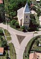
View of the reformed church

View of the Roman Catholic. Győzedelmes Church Szűz Mária

