Helmhütte
| Helmhütte (closed) |
||
|---|---|---|
|
The Helmhütte from an Austrian perspective |
||
| Geographical location: | 46 ° 42 '54 " N , 12 ° 23' 14" E | |
| Altitude | 2433 m | |
|
|
||
| Built | 1889 | |
| Construction type | hut | |
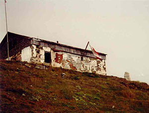
The Helmhütte (also Helmhaus , 2433 m ) is a former refuge of the Sillian section of the DuOeAV or a former border hut in Italy on the ridge between South and East Tyrol . The Sillian and Drei Zinnen Alpine Club and the neighboring communities have been discussing the further use of the dilapidated hut for several years . The spectrum ranges from a new building to a renovation to the demolition and construction of a war memorial at the same location.
location

Located on the Helm summit , the Helmhütte forms the beginning and end of the Carnic High Trail . It has a striking location and is a popular vantage point with a view of the South Tyrolean and East Tyrolean Dolomites and the main Alpine ridge . The hut is located directly on the Austrian- Italian state border, which was established after the First World War .
history
The Sillian Alpine Club section began building the Helmhütte in 1889. The Sesto community provided the building site for the refuge. Two years later, the hut with a viewing platform on the roof was completed and inaugurated on July 25, 1891. After the end of the First World War, the Austrian-Italian border was redrawn with the Treaty of St. Germain . The Helmhütte was now directly on the border. In 1925 the refuge had to be ceded to the Italian state by the State Treaty of Venice. It was then converted for military use as a customs house. The viewing platform on the roof was removed for this purpose.
In the mid-1920s, the fascists under Benito Mussolini came to power in Italy. These promoted the construction of border fortifications and bunker complexes along the Austrian-Italian border. The Helmhütte thus became the core of an extensive military area. The ruins of these facilities are still visible today.
After the end of the Second World War , the Helmhütte remained in Italian ownership, but was no longer used from the 1970s. The refuge fell into disrepair in the following decades. In 1999 the hut became the property of the Province of South Tyrol. On February 25, 2013, the South Tyrolean provincial government decided to sell the ruins to the municipality of Sexten , which plans to build a documentation center on the mountain war .
Approaches
The following ascents are possible to the Helmhütte:
- After ascent with the Sexten mountain railway, from the mountain station at 2,052 m, via a former military road to the summit of the Helm.
- After ascent with the Vierschach mountain railway, from the mountain station at 2,045 m, also via the military road to the summit.
- From Sillian on foot or by car to the Leckfeldalm and from there via a sidewalk to just below the Sillianer Hütte to the summit of the Helm.
- From Sillian / Kühstille on foot via Hasslrauth and the Forcher Kaser to the summit of the Helm.
literature
- Martin Achrainer, Florian Trojer: The missed opportunity of politics . In: Experience the mountains - The magazine of the Alpine Association of South Tyrol . No. 3 , 2019, p. 47-49 .
Web links
Individual evidence
- ↑ a b c History of the Sillian Section
- ^ Anton Sint, Gerhard Holzer, Benedikt Sauer : Das Helmhaus. Austrian Alpine Club - Sillian Section, accessed on September 22, 2017 .
- ↑ Sold ruin. (No longer available online.) Tageszeitung.it , February 25, 2013, archived from the original on May 12, 2013 ; Retrieved February 25, 2013 . Info: The archive link was inserted automatically and has not yet been checked. Please check the original and archive link according to the instructions and then remove this notice.

