
Breezes
| Breezes | ||
|---|---|---|
 The breezes seen from Haldigrat. |
||
| height | 2403 m above sea level M. | |
| location | Canton border Nidwalden / Uri , Switzerland | |
| Mountains | Uri Alps | |
| Dominance | 4.6 km → Ruchstock | |
| Coordinates | 677 700 / 194 689 | |
|
||
 The higher Hoh Brisen from the summit of the Brisen, Uri Rotstock in the background on the right |
||

The breeze is a 2403 m above sea level. M. high summit of the Urner Alps in Switzerland .
geography
The breeze lies between the Engelbergertal and the Isental on the canton border between Nidwalden and Uri . The mountain marks the western end point of a long mountain ridge , which runs up to the Oberbauenstock and whose highest point it is. The Haldigrat falls towards the Engelbergertal and separates the Steinalp above Niederrickenbach from the Sinsgäu near Oberrickenbach . A third ridge runs east to the Hoh Brisen , which is 2413 m above sea level. M. is even a little higher and is only separated from the breeze by a 70 meter deep saddle. Since the Hoh Brisen is not visible from the north and is not accessible to tourists, the Brisen is perceived as the main peak. South of the breeze is the almost equally high Chaiserstuel .
reachability
The breeze can be reached from all directions via mountain hiking trails . The two best-known routes lead from the Haldigrat over the west ridge or from the Brisenhaus and the Steinalper Jochli through the east flank and in the uppermost section over the northeast ridge. These two trails are classic mountain hiking trails and also allow you to cross the mountain as a day tour. Other paths lead from Gitschenen or from Sinsgäu on the Brisen, although these are partly pathless alpine hiking trails and in particular the path from Sinsgäu via Windegg is demanding and very steep.
Another well-known route leads from the Brisen over the Risetenstock to the Oberbauenstock. The almost 10 km long path mostly follows the ridge and leads in sections through steep and pathless terrain. It is therefore only suitable for sure-footed hikers who are free from giddiness.
Accommodations
The Brisenhaus is north of the Brisen at an altitude of 1753 m above sea level. M. and is maintained by the Pilatus Section of the SAC . It is manned in summer and offers around 50 beds. A shelter is available in winter, but there is no classic winter room.
In the east there is an inn of the same name on the Alp Gitschenen , the highest year-round inhabited settlement in the municipality of Isenthal in the canton of Uri, in the west there is a mountain restaurant on the Haldigrat, which can be easily reached by a chairlift from Niederrickenbach.
gallery

The breeze from the west ridge seen a little above the Haldigrat

View from the west ridge of Oberrickenbach , Wellenberg and the lower Engelbergertal

View from the west ridge to Haldigrat and Stanserhorn . In the background Mount Pilatus
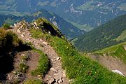
Path on the west ridge

Just below the summit. View towards Uri Rotstock

View from the summit in south direction. In the foreground the whale sticks , left in the background the Titlis

View from Steinalper Jöchli towards Gitschenen

Descent to the Brisenhaus . Elfer and Vierwaldstättersee . On the left the Musenalp and the Buochserhorn . Rigi in the background on the right


literature
- National map 1: 25,000: Sheet 1171, Beckenried
- National map 1: 50,000: sheet 245, Stans
- SAC Club Guide: Central Swiss Pre-Alps
- SAC Club Guide: Alpine Ski Tours 1 Central Switzerland-Ticino
Individual evidence
- ↑ breezes. Retrieved March 30, 2020 .
- ↑ breezes. Retrieved March 30, 2020 .
- ↑ breezes. Retrieved March 30, 2020 .
- ↑ Hiking map Engelberg 1: 50,000
- ↑ Brisenhaus. Retrieved March 30, 2020 .
- ↑ Haldigrat. Retrieved March 30, 2020 .
- ↑ Gitschenen mountain inn. Retrieved March 30, 2020 .
Web links
- Breezes on hikr.org