
Holderbach (Katzenbach)
|
Holderbach Dorfbach Affoltern (Unterlauf), Mühlebach (formerly) |
||
 Holderbach with Tobelholzbrücke in the upper part of the Tobel |
||
| Data | ||
| Water code | CH : ZH101801 | |
| location | Zurich | |
| River system | Rhine | |
| Drain over | Katzenbach → Leutschenbach → Glatt → Rhine → North Sea | |
| source | at Hönggerberg 47 ° 24 ′ 32 " N , 8 ° 29 ′ 46" E |
|
| Source height | 526 m above sea level M. | |
| muzzle | at Unteraffoltern in the Katzenbach coordinates: 47 ° 25 '40 " N , 8 ° 30' 48" E ; CH1903: 681 084 / 253557 47 ° 25 '40 " N , 8 ° 30' 48" O |
|
| Mouth height | 437 m above sea level M. | |
| Height difference | 89 m | |
| Bottom slope | 23 ‰ | |
| length | 3.8 km | |
| Catchment area | 2.33 km² | |
| Discharge at the level of Schauenbergstrasse A Eo : 2 km² |
MQ Mq |
15 l / s 7.5 l / (s km²) |
| Left tributaries | Mittelwaldbach, Hungerbach | |
| Right tributaries | Rohrgraben, Hallernbach | |
| Big cities | Zurich | |
The Holderbach (in the lower reaches of Dorfbach Affoltern ) is a 3.8 kilometer long right tributary of the Katzenbach in the city of Zurich . It rises in Zurich's Höngg district , flows through a ravine on the Hönggerberg (formerly called Hintertobel ) and crosses the Affoltern district before it flows into the upper reaches of the Katzenbach. The stream drains large parts of the Hönggerberg and the western slope of the Käferberg .
geography


course
The Holderbach rises under a street at the sports and shooting range Hönggerberg on the southwest slope of the mountain of the same name at 526 m above sea level. M. The first approximately 540 meters it extends covered over the edge of the forest predominantly eastward direction campus of ETH Zurich . Shortly before it, at the confluence of the pipe trench from the right, it turns to the northwest and comes to the surface for the first time. It now flows through the forest area and after the confluence of the Mittelwaldbach forms a ravine from the left, which becomes increasingly steeper and extends slightly into the settlement area of Affoltern. The ravine opens again in front of the Schauenbergstrasse and the stream is overturned again at the end of the Holderbachweg for around 240 meters. In this section, a flood relief channel branches off under Zehntenhausplatz , which meets the Holderbach again at Alte Mühlackerstrasse . After this place, thanks to renaturation measures, the stream mostly runs on the surface, only short sections are overturned here. That changes when you reach Alte Mühlackerstrasse , where the stream at Unteraffoltern has been relocated under the ground for around 430 meters. Then it flows through the Grütwisen parallel to the A4 and finally flows at 437 m above sea level. M. from the right in the upper reaches of the Katzenbach.
Catchment area
The 2.33 square kilometer catchment area extends from the mouth of the Holderbach to 437 m above sea level. M. up to 582 m above sea level. M. high Waidberg , the higher secondary summit of the Käferberg. The average altitude is 498 m above sea level. M. The area is made up of 53.5% of built area, 32.3% semi-natural area and forest and 14.3% of agricultural land.
This also includes two rain retention basins that store all the water on the ETH campus. This water is fed to the Holderbach in a throttled manner.
Tributaries
- Rohrgraben, from the right and northeast to 517 m above sea level. M. in the corridor pipe , 0.94 km long. Rises in the Siebenjucharten corridor on Käferberg at 534 m above sea level. M. , joins its right source stream shortly afterwards and touches the ETH campus in the south and west.
- Mittelwaldbach, from the left and northwest at 510 m above sea level. M. in the Chappeli forest , 0.65 km long. Rises in the woodland clay pits near the Holderbach at 524 m above sea level. M. and joins shortly afterwards with its left source stream before it flows through the Kappeliholzweiher. Sometimes there is no water in the lower reaches.
- Hallernbach, from the right and southeast to 504 m above sea level. M. in the Hallern forest , 0.09 km long. Rises at 514 m above sea level. M. and only flows through the eponymous forest hall, Hallern . It drains most of the ETH campus underground. Sometimes there is no water.
- Hungerbach, from the left and northwest at 467 m above sea level. M. on the Tobelsteig , 0.78 km long. Rises at Hungerberg on the north slope of the Hönggerberg at 521 m above sea level. M. and crossed parts of Affoltern.
history
The Holderbach was used very early, so the first miller was mentioned in 1381 .
In 1874 the government council of the canton of Zurich approved the construction of a sawmill with mill and pond between Ober- and Unteraffoltern in today's Flur Müli . The mill building later burned down and the permit expired in September 1927. The pond was then filled in, but the sawmill remained for some time.
Between 1902 and 1912 the brook was overturned in Affoltern. In 2006, Abfall + Recycling Zürich built a wooden rake with a volume of 200 m³ and a maintenance path at the exit of the ravine . Two wooden trunks were also placed horizontally to create a spawning pond for amphibians. The bed load collector below was adapted and the intake structure was completely rebuilt, with the area of the rake being more than doubled. Furthermore, the stream below Zehntenhausplatz was exposed over a length of around 600 meters. The reason for the expansion was several floods caused by the small capacity of the sewer network and three times by the clogging of the intake structure with driftwood.
In 2009, a 110-meter-long section between Zehntenhausplatz and the railroad tracks was revealed, which increases the capacity to 800 l / s. However, when it rains heavier, part of the water flows through the flood relief channel, which meets the Holderbach again below. At the same time as the construction work, the exposed stream was also ecologically upgraded.
geology
The source area of the brook lies on a moraine from the Würm glacial period , the Quaternary loose rock of which is composed of clays , silts and sands and is around 16 meters thick . A moraine wall running from west to east, which extends from Flur Ober Giblen to Flur Berg , prevents the river from flowing south to the Limmat . At Rohr , it encounters Quaternary clay , which is deposited in a hollow between two moraine walls . It breaks through the northern moraine wall between Chappeli and Hallern before it forms a ravine cut deep into the moraine. The broken moraine wall now stretches along the left side of the ravine, while another moraine wall joins on the right bank, which directs the stream to the north-northwest.
In Tobel the Holderbach on is molasses - sandstone encountered, by tertiary sediments of the Upper Süddwassermolassen emerged. In the middle section of the ravine, sandstone with developed knuckles of the Hörnli and Napf fill is exposed on the left and right banks . In the lower part of the ravine a larger extends along the left bank slip area and at the output of the ravine Holderbach stream debris has accumulated with a thickness around 16 meters.
The stream now encounters fluvial deposits in Oberaffoltern within the Schlieren stage, which are covered by thin gravel . In the lowest part, in front of the Grütwisen corridor , these deposits mainly consist of sand . The Holderbach flows through peaty soil for the last few meters .
flora
On the Hönggerberg, in its Waldtobel, the brook mostly flows through maple - ash forest with bingelkraut and typical lungwort - beech forest . In the middle part of the gorge there is a typical, species-poor tooth root beech forest.
There are two forest sites of natural significance along the course of the stream, in which no wood is used, but the focus is on biological diversity. In Chappeli of 6.5 hectare forest site is Hönggerberg-Kappel , composed of rare and culture-related forest companies, while most of the ravine in 7.04 hectare forest site Tobel timber is located.
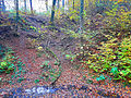
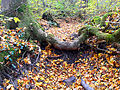
photos

Holderbach at the beginning of the ravine shortly after the confluence of the Mittelwaldbach

Bridge over the Holderbach in the middle part of the ravine
Confluence of the Hallernbach with a dry stream bed at the end of October
Dry creek bed of the Mittelwaldbach just before its actual mouth


Web links
swell
Individual evidence
- ↑ a b c d e f g individual records geographic information system of the canton of Zurich
- ↑ a b Geoserver of the Swiss Federal Administration ( information )
- ↑ a b c d e The Holderbach at a glance. In: City of Zurich. Retrieved October 26, 2015 .
- ↑ Modeled mean annual discharge. In: Topographical catchment areas of Swiss waters: sub-catchment areas 2 km². Retrieved October 3, 2016 .
- ↑ City streams - discover Zurich's green oases. In: City of Zurich. Retrieved October 10, 2016 .
- ↑ Topographical catchment areas of Swiss waters: area outlets Federal Office for the Environment FOEN
- ↑ Own observation
- ↑ Own observation
- ↑ State Archives of the Canton of Zurich Z 1.1082 No. 1: Zurich Affoltern. Hydropower plant at Dorfbach and Holderbach or sources from Höngger Berg; Pond, mill; Saw. Expired on September 8, 1927, 1874–1928 (Dossier)