Wooden
|
Wooden
Eberstadt municipality
|
|
|---|---|
| Coordinates: 49 ° 10 ′ 45 ″ N , 9 ° 20 ′ 46 ″ E | |
| Height : | 202 m |
| Area : | 2.52 km² |
| Residents : | 340 (2009) |
| Population density : | 135 inhabitants / km² |
| Incorporation : | 1st January 1971 |
Holz is a formerly independent place that has belonged to the municipality of Eberstadt in the Heilbronn district in north-eastern Baden-Württemberg since 1971 . It was first mentioned in the High Middle Ages and today has around 320 inhabitants.
geography
Holz is located at the upper, eastern end of the Eberbachtal, about 1 km east of Eberstadt. The Eberbach, a tributary of the Sulm , rises further north at the hamlet of Klingenhof, which also belongs to Eberstadt, and flows past Holz, where a stream flows into it, past Eberstadt in the west. While the valley spanned at this point by the A 81 opens to the west , Holz is surrounded by mountain slopes in the other three cardinal directions, those in the north up to the height of vineyards and only on top of the forest , in the east and south, however, also further are covered by forest below. Through the forest to the east, the road leads to Öhringen that of Eberstadt or vineyard comes and not steep woods behind on one, but long walkways leading up the hill.
history
Excavation finds suggest that a forerunner of the road along which wood is located already existed in the Iron Age . The Roman road, which connected the forts Böckingen and Öhringen , probably also ran through Holz.
Whether the mention of a place called Holßhofen (also Holsshofen or Holshofen ) in a document from around 1100 refers to wood is a matter of dispute . The instrument is in a copy of the 16th century in the Codex Hirsaugiensis contain ( Cod. Hirsaug. 56 b ) and documented that Cunisa de Wirspach or Cuniza of Würzbach, mother of Count Adelbert (III.) Of Calw , the Hirsau a villula Holsshofen apud Winsperg sita bequeathed. In 1247 the Oberstenfeld Abbey is mentioned for the first time as being wealthy in Holz, which had many rights in the village until it was mediatized in 1803 and to which one of the wooden wine presses belonged.
The name Holz derives from its location close to the forest. In 1247 the place is mentioned as Holzern , in documents from 1402 and 1602 as Holtzern .
In the 14th century, the lords of Weinsberg were local lords in Holz, the place was lent to the Hochstift Würzburg . With the decline of the Weinsbergers, woods like the surrounding towns came to the Electoral Palatinate in 1450 and to Württemberg in 1504 . The Thirty Years War hit the place hard.
Holz belonged to the office, later to the Oberamt Weinsberg , after its dissolution in 1926 to the Oberamt Heilbronn , today's district of Heilbronn . The population fluctuated between 190 people in 1725 and 327 in 1798 and 319 in 1880. In 1925 there were 236 inhabitants. On May 27, 1970, the day of the census, the high of 420 inhabitants was reached, which has since fallen to around 320 inhabitants. On January 1, 1971, Holz was voluntarily incorporated into Eberstadt.
badges and flags
The blazon of the wooden coat of arms reads: In silver a rooted green oak, the trunk of which is accompanied by a green label on each side. The municipality's flag was green and white.
The oak as an allusion to the place name Holz has been found in seals of the place since around 1280 . In 1938 the Württemberg archives suggested a green oak in a silver field as a coat of arms. To distinguish them from similar coats of arms, on the advice of the archives department, the two labels were added in 1960/61, which, as a symbol of Holzer's earlier affiliation to the Weinsberg rule, were taken from the coat of arms of the Lords of Weinsberg ( three silver labels in red ), but the color was taken from the oak have been adjusted. The coat of arms and flag were awarded to the community on June 20, 1961 by the Baden-Württemberg Ministry of the Interior.
Buildings
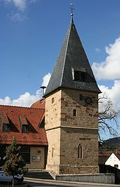
The 25 meter high tower is the only remnant of the wooden church from 1208. The nave was demolished in 1842, the multi-purpose house attached to the tower dates from 1978/79. At Gasthaus Adler, mentioned in 1634, there are wooden pillars from 1584, which were once part of the Eberstadt church. The former town hall dates from 1625 (rebuilt in 1774), a house built for a wooden mayor (later Gasthaus Sonne ) according to two inscriptions from 1726 and 1767. There is also an old bakery in the village.
traffic
Holz is located on the road from Weinsberg to Öhringen (today state road 1036 ), which connects the Eberbachtal with the Brettachtal and climbs the hill in between in a long climb. This climb on the road, which was heavily frequented until the Crailsheim – Heilbronn railway was built in 1862, had to be negotiated with additionally harnessed draft horses in the age of horse-drawn vehicles, which is why there were many hostels in Holz in the past, at least six in 1490, four in 1548 and thus significantly more than in comparable ones Villages.
The Federal Highway 81 , completed in 1973, spans the Eberbachtal immediately west of Holz and, with the Hölzern tunnel, crosses the Hölzerner Plain between the Eberbach and Brettachtal valleys north of the village . The next motorway junction is a few kilometers away in Weinsberg, where the A 81 and A 6 motorways intersect at the Weinsberger Kreuz .
The closest train station is in Weinsberg on the Crailsheim – Heilbronn railway line; local public transport is carried out by bus to get there.
literature
- Heinz Dörnen: Eberstadt. A chronicle of the community . Municipality of Eberstadt, Eberstadt 1985. Therein v. a. Pp. 163-173.
Web links
- Embedded in the vine landscape . Portrait of Hölzern on eberstadt.de (accessed on July 27, 2008)
Individual evidence
-
↑ a b Additional sources for the sections geography and traffic: Topographische Karte 1:25 000. Sheet 6722 Hardthausen am Kocher . 8th edition. State Surveying Office Baden-Württemberg, Stuttgart 2002, ISBN 3-89021-049-X .
Topographic map 1:25 000. Sheet 6821 Heilbronn . 3. Edition. Land survey office Baden-Württemberg, Stuttgart 2001, ISBN 3-89021-059-7 .
Topographic map 1:25 000. Sheet 6822 Obersulm . 8th edition. State Surveying Office Baden-Württemberg, Stuttgart 2000, ISBN 3-89021-060-0 . - ↑ a b c d The state of Baden-Württemberg. Official description by district and municipality. Volume IV: Stuttgart district, Franconian and East Württemberg regional associations. Kohlhammer, Stuttgart 1980, ISBN 3-17-005708-1 , p. 147.
- ↑ Wüstung Oberwürzbach: Research in an abandoned settlement in the northern Black Forest ( Memento of the original from December 16, 2015 in the Internet Archive ) Info: The archive link was inserted automatically and has not yet been checked. Please check the original and archive link according to the instructions and then remove this notice. at the Institute for Prehistory and Early History and Archeology of the Middle Ages of the Eberhard-Karls-Universität Tübingen, Department for Archeology of the Middle Ages (accessed on September 14, 2012)
- ^ Federal Statistical Office (ed.): Historical municipality directory for the Federal Republic of Germany. Name, border and key number changes in municipalities, counties and administrative districts from May 27, 1970 to December 31, 1982 . W. Kohlhammer, Stuttgart / Mainz 1983, ISBN 3-17-003263-1 , p. 450 .
- ↑ Source for the section coat of arms and flag: Eberhard Gönner: Wappenbuch des Stadt- und Landkreis Heilbronn with a territorial history of this area . Archive Directorate Stuttgart, Stuttgart 1965 (Publications of the State Archives Administration Baden-Württemberg, 9), p. 96.
- ↑ Additional source for the section buildings: Julius Fekete: Art and cultural monuments in the city and district of Heilbronn . 2nd Edition. Theiss, Stuttgart 2002, ISBN 3-8062-1662-2 , pp. 142-144.
- ↑ Hartmut Gräf: The offices of Neuenstadt am Kocher and Weinsberg at the turn of the modern era . Thorbecke, Ostfildern 2004 (Research from Württembergisch Franken, 51), ISBN 3-7995-7652-5 , pp. 107–112.
Remarks
-
↑ The text reads:
Cunisa de Wirspach, mater Adalberti comitis, villulam, que dicitur Holsshofen, apud Winsperg sitam, sanctis apostolis Petro et Paulo atque Aurelio in siluis et in agris pene viginti hubas et molendinum vnum in eodem loco contradidit. Quoted from Codex Hirsaugiensis . Stuttgart, Literarischer Verein 1843 (library of the literary association in Stuttgart, 1.5). P. 82 (online here at the Freiburg University Library)
While the local history (see literature) assumes that this place is about wood, and that is why the municipality of Eberstadt celebrated the 900th anniversary of wood in 2000 (see portrait Holzs on web links), others deny Holßhofen’s identity with wood, according to Ostertag / Koch in Burg und Stadt Weinsberg , Stadt Weinsberg, Weinsberg 1977, on p. 26, because a mill is mentioned in the text section of the Codex Hirsaugiensis in question, and none in Wood is still attested on the upper reaches of the Eberbach. Dumitrache / Haag also describe Holßhofen in the Weinsberg archaeological city cadastre , Baden-Württemberg State Monument Office, Stuttgart 1999, on p. 18/19 as “not yet localized”. Both Ostertag / Koch and Dumitrache / Haag suspect Holßhofen to be closer to Weinsberg.


