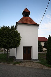
Horní Lhotice
| Horní Lhotice | ||||
|---|---|---|---|---|
|
||||
| Basic data | ||||
| State : |
|
|||
| Region : | Kraj Vysočina | |||
| District : | Třebíč | |||
| Municipality : | Kralice nad Oslavou | |||
| Area : | 309 ha | |||
| Geographic location : | 49 ° 12 ' N , 16 ° 13' E | |||
| Height: | 435 m nm | |||
| Residents : | 128 (2011) | |||
| Postal code : | 675 73 | |||
| License plate : | J | |||
| traffic | ||||
| Street: | Kralice nad Oslavou - Horní Lhotice | |||
Horní Lhotice , until 1960 Lhotice (German Lhotitz , 1939–45 Elhotitz ) is a district of the municipality of Kralice nad Oslavou in the Czech Republic . It is located five kilometers east of Náměšť nad Oslavou and belongs to the Okres Třebíč .
geography
Horní Lhotice is located in the foothills of the Křižanovská vrchovina ( Krischanauer Uplands ) in the south of the Bohemian-Moravian Highlands . The village, surrounded by extensive forests, is located on a plateau between the valleys of the Jinošovský potok and Chvojnice brooks . To the northeast is the Chvojnice reservoir, also known as the Kralice reservoir, and the Práchovna pond to the west.
Neighboring towns are Hluboké in the north, Horní Mlýn, Újezd u Rosic and Březina in the north-east, Lesní Jakubov in the east, Rapotice and Sudice in the south-east, Spálený Mlýn, Olšinský Mlýn and Březník in the south, Kralice nad Oslavou in the south-west, as well as Náměnad Oslavou in the south-west Otradice and Jinošov in the northwest.
history
The first written mention of Lhotice was in 1104 in the founding document of the Benedictine monastery Třebíč . In the 13th and 14th centuries there were two medieval castles on a spur around which the Chvojnice rivers . Nothing is known about their history. Dolní hrádek is considered the seat of the Lords of Lhotice and was abandoned in the second half of the 14th century. The younger castle Horní hradek was probably the seat of the Lords of Jakubov, later the Jakubov Bell Hill and was extinct at the beginning of the 15th century. Since 1378 Lhotice is documented in the Brno land table as the property of the Vladiken family Kralický von Kralice; in the same year Ingram von Kralitz prescribed the Freihof in Lhotice to his wife Elisabeth . After the death of her husband in 1385, Elisabeth gave her Wittum auf Lhotice and Jinošov to her brother Ulrich von Lewenau and Znata Hecht von Rossitz. The following year, the widow compared with the heir Niklas von Kralitz because of the property in Lhotice and Jinošov; She sold the fortress and the Jinošov manor to Přiznak from Lipultice. In 1573 Heinrich von Kralitz sold his family seat - the Kralice fortress with the villages of Kralice, Lhotice and Jakubov as well as the desert castle Kraví Hora with part of Kuroslepy to the owner of the Namiest domain , John the Elder of Zierotin .
In 1837 the village of Lhotitz or Lhotice in the Znojmo district consisted of 22 houses in which 168 people lived. The parish was Jeneschau . Until the middle of the 19th century, Lhotitz remained subject to Fideikommissgrafschaft Namiest.
After the abolition of patrimonial formed Lhotice / Lhotitz 1849 a district of the municipality Kralice in the judicial district Namiest . From 1869 Lhotice belonged to the Trebitsch district. At that time the village had 188 inhabitants and consisted of 24 houses. In 1879 Lhotice and Jakubov broke away from Králice and formed the municipality of Lhotice. In 1900 there were 172 people in Lhotice ; In 1910 there were 167. In 1907 Jakubov formed its own parish. In the 1921 census, 165 people lived in the municipality's 35 houses, 161 of them Czech. In 1930 Lhotice consisted of 36 houses and 159 inhabitants. In 1933 the road from Kralice to Lhotice was built. Between 1939 and 1945 Lhotice / Elhotitz belonged to the Protectorate of Bohemia and Moravia . In 1948 the municipality was assigned to the Okres Velká Bíteš. In 1950 Lhotice had 137 inhabitants. In the course of the territorial reform and the abolition of the Okres Velká Bíteš, the municipality was assigned to the Okres Třebíč on July 1, 1960 ; to distinguish it from another Lhotice in the same district, the municipality name was changed to Horní Lhotice . In 1961 it was incorporated into Kralice nad Oslavou. In the 2001 census, there were 108 people in the 40 houses in Horní Lhotice.
Community structure
The Horní Lhotice district forms a cadastral district.
Attractions
- Chapel of the Holy Spirit, built in 1723. In 1934 it was redesigned.
- Remains of the castles Horní hrádek and Dolní hrádek, on the right side of the Chvojnice between Horní Lhotice and Lesní Jakubov. The walls and moats have been preserved. During archaeological investigations by Josef Unger and Pavel Koštuřík in the 1960s, part of the Dolní hrádek castle wall was uncovered. The suspicion arose that the system may have remained unfinished.
literature
- Historický lexikon obcí České republiky 1869–2005 , part 1, p. 588
Web links
- Dolní hrádek , hrady.cz
- Horní hrádek , hrady.cz
Individual evidence
- ↑ http://www.uir.cz/katastralni-uzemi/672475/Horni-Lhotice
- ^ Gregor Wolny : The Margraviate of Moravia, presented topographically, statistically and historically . Volume III: Znojmo District, Brno 1837, p. 449
- ↑ Chytilův místopis ČSR, 2nd updated edition, 1929, pp. 636-637 Lhota Velká - Lhotice
- ↑ https://www.pamatkovykatalog.cz/zricenina-hradu-hradek-675797


