
Hornbach (Lech)
| Hornbach | ||
 |
||
| Data | ||
| Water code | AT : 2-4-65 | |
| location | Ausserfern , Tyrol , Austria | |
| River system | Danube | |
| Drain over | Lech → Danube → Black Sea | |
| source | in March hole 47 ° 19 '31 " N , 10 ° 21' 35" O |
|
| Source height | 1995 m above sea level A. | |
| muzzle | near Vorderhornbach in the Lech coordinates: 47 ° 22 '2 " N , 10 ° 33' 4" E 47 ° 22 '2 " N , 10 ° 33' 4" E |
|
| Mouth height | 945 m above sea level A. | |
| Height difference | 1050 m | |
| Bottom slope | 61 ‰ | |
| length | 17.3 km | |
| Catchment area | 64.7 km² | |
| Discharge at the Vorderhornbach gauge (bridge) A Eo : 64 km² Location: 1.02 km above the mouth |
NNQ (03/11/2009) MNQ 1976–2010 MQ 1976–2010 Mq 1976–2010 MHQ 1976–2010 HHQ (08/22/2005) |
230 l / s 730 l / s 3.84 m³ / s 60 l / (s km²) 44.6 m³ / s 71.2 m³ / s |
| Left tributaries | Jochbach | |
| Communities | Hinterhornbach, Vorderhornbach | |
The Hornbach is a 17 km long left tributary of the Lech in the Reutte district in Tyrol , Austria . It is fed by mountain streams that come from the Hochvogel , the Urbeleskarspitze and the Marchspitze . It then flows in a north-easterly direction through the Hornbachtal and flows into the Lech at Vorderhornbach . In the Lech Valley, he raised an alluvial cone on which the Vorderhornbach lies.
The catchment area is around 65 km² and extends from 945 m above sea level. A. (Lechtal) up to 2632 m above sea level. A. (Urbeleskarspitze).
The mean discharge at the Vorderhornbach gauge is 3.84 m³ / s, which corresponds to a very high discharge rate of 60 l / s · km². The Hornbach has a similar discharge regime , which is dominated by the snowmelt in the higher areas of the catchment area. The monthly mean of the month of June with the most discharge is, at 8.39 m³ / s, almost seven times higher than that of the month of February with the lowest discharge, with 1.23 m³ / s.
The two small villages of Vorder- and Hinterhornbach and a large mountain range in the Allgäu Alps are named after the brook : the Hornbach chain .
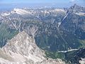
The Hornbachtal from the Noppenspitze , on the right the Hochvogel

The Hornbachtal with the Hochvogel


Web links
- Water level and flow at the Vorderhornbach gauge (bridge) (Hydrographischer Dienst Tirol)
Individual evidence
- ↑ a b c d TIRIS - Tyrolean spatial information system
- ↑ a b Federal Ministry of Agriculture, Forestry, Environment and Water Management (Ed.): Hydrographisches Jahrbuch von Österreich 2010. 118th volume. Vienna 2012, p. OG 83, PDF (12.6 MB) on bmlrt.gv.at (yearbook 2010)