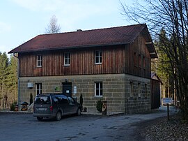
Horseshoe forest house
|
Horseshoe forest house
City of Pegnitz
Coordinates: 49 ° 41 ′ 48 " N , 11 ° 29 ′ 43" E
|
|
|---|---|
| Height : | 450 m above sea level NHN |
| Residents : | 3 (1987) |
| Postal code : | 91257 |
| Area code : | 09241 |
|
The Pegnitz district of Hufeisen-Waldhaus
|
|
Hufeisen-Waldhaus is a district of the town of Pegnitz in the Upper Franconian district of Bayreuth .
geography
The wasteland is located about seven kilometers south-southwest of Pegnitz and about five kilometers north-northeast of Plech . It is located at an altitude of 450 m above sea level. NHN as a settlement enclave in the large, community-free Veldenstein Forest .
history
As a result of the administrative reforms carried out in the Kingdom of Bavaria at the beginning of the 19th century , the independent rural community of Ottenhof was founded, which also included the church village of Bernheck and the wasteland of Strüthof . The wilderness of the horseshoe forest house did not exist at this time, but was only assigned to the community of Ottenhof after its construction. In the course of the municipal territorial reform carried out in Bavaria in the 1970s , Hufeisen-Waldhaus was re- municipalityed to Pegnitz, whereas the remaining part of the municipality of Ottenhof was incorporated into the market town of Plech. In 1987, Horseshoe Forest House had three residents.
traffic
The district road BT 28 connects Hufeisen-Waldhaus to the public road network, it runs directly west of the place. There is access to the Federal Motorway 9 at the Plech and Pegnitz junctions, each about four kilometers away. In the local public transport , the Verkehrsverbund Großraum Nürnberg (VGN) drives to the Hufeisen-Waldhaus during the day with the regional bus routes 380 and 386.
Web links
- Horseshoe forest house in BayernViewer (accessed on November 29, 2017)
- The area of the later horseshoe forest house on a historical map (accessed on November 29, 2017)
Individual evidence
- ↑ Population of Hufeisen-Waldhaus on the website of the Verein für Computergenealogie e. V. (accessed on November 29, 2017)
- ^ Horseshoe forest house in the local database of the Bavarian State Library Online . Bayerische Staatsbibliothek (accessed on November 29, 2017)
- ↑ Geographical location of the horseshoe forest house in the BayernAtlas (accessed on November 29, 2017)
- ↑ Political composition of the rural community of Plech (accessed on November 29, 2017)
- ^ Federal Statistical Office (ed.): Historical municipality directory for the Federal Republic of Germany. Name, border and key number changes in municipalities, counties and administrative districts from May 27, 1970 to December 31, 1982 . W. Kohlhammer, Stuttgart / Mainz 1983, ISBN 3-17-003263-1 , p. 697 .

