Hoof house
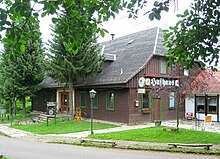
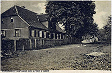
The Hufhaus is a former stud and forester's house in the southern Harz in the Nordhausen district in Thuringia . It is located northeast of Ilfeld at an altitude of 530 m above sea level. NN above the Hufnageltal not far from the Poppenberg . The Hufhaus, which belongs to the rural community of Harztor , is 6 km from the nearest public road ( B 81 ).
After the estate of the Counts of Stolberg was divided in 1645 into the older main line Stolberg-Wernigerode and the younger main line Stolberg-Stolberg , the line Stolberg-Wernigerode received the Hohnstein Forest. By comparison of March 22, 1697, the Counts of Stolberg-Wernigerode had to cede their stud on the Lange above the Bodetal , as it was located in the ducal-Braunschweig area. As a replacement for this, the Hufhaus was built as a stud, which was put into operation in 1698 with 13 mares.
The name Hufhaus is explained by this fact. The meaning of the name is also confirmed by the Hufnageltal valley running north below the Hufhaus and the horse shark district further north above it .
In 1703 the horse disease Druse circulated in the stud , and in January 1704 the stud burned down, in 1705 the reconstruction took place. In 1806 the Hufhaus was "[...] a cattle yard, together with a forester's apartment and tavern in the Stolberg-Wernigerodeschen part of the forests belonging to the Hohnstein office, not far from Birkenmohr." In 1820 the Hufhaus became a forest ranger's house.
The area around the Hufhaus has been used as a recreation center since 1970. The VEB Nordbrand Nordhausen extended the old Hufhaus in 1976 and converted it to operate holiday home. To the south of the Hufhaus, VEB Betonwerke Heringen built the “Harzhöhe” rest home.
Today the Hufhaus is a settlement of a few houses and bungalows that are used for gastronomic purposes.
Web links
- Local history museum Ilfeld: The chronicle of the community of Ilfeld. (PDF; 223 kB)
Individual evidence
- ^ Friedrich Gottschalck: Paperback for travelers in the Harz. With a charter. Keil, Magdeburg 1806, p. 248
Coordinates: 51 ° 35 ′ 55.6 ″ N , 10 ° 50 ′ 58 ″ E

