Ingenio
| Ingenio municipality | ||
|---|---|---|
| coat of arms | Map of the Canary Islands | |

|
|
|
| Basic data | ||
| Autonomous Community : | Canary Islands | |
| Province : | Las Palmas | |
| Island: | Gran Canaria | |
| Coordinates | 27 ° 55 ′ N , 15 ° 25 ′ W | |
| Height : | 558 msnm | |
| Area : | 38.15 km² | |
| Residents : | 31,321 (Jan. 1, 2019) | |
| Population density : | 821 inhabitants / km² | |
| Postal code : | E-35350 | |
| Municipality number ( INE ): | 35011 | |
| administration | ||
| Mayor : | Ana Hernández Rodríguez (as of 2020) | |
| Address of the municipal administration: | Plaza de la Candelaria, 1 35250 - Ingenio |
|
| Website : | ingenious | |
| Location of the municipality | ||

|
||
Ingenio (derived from Spanish ingenio azucarero , sugar factory ) is a municipality on the Canary Island of Gran Canaria . Ingenio has 31,321 inhabitants (as of January 1, 2019) on an area of 38.83 km².
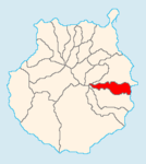
Ingenio is south of Telde and northeast of Agüimes in the south and Valsequillo de Gran Canaria in the west.
Residents
| year | Residents | Population density |
|---|---|---|
| 1991 | 21,807 | - |
| 1996 | 24,394 | - |
| 2001 | 24,439 | 643.1 inhabitants / km² |
| 2002 | 25,681 | - |
| 2003 | 26,433 | 692.9 inhabitants / km² |
| 2004 | 26,857 | 691.7 inhabitants / km² |
| 2005 | 27.308 | 715.8 inhabitants / km² |
photos
- Church of Ingenio
Individual evidence
- ↑ Cifras oficiales de población resultantes de la revisión del Padrón municipal a 1 de enero . Population statistics from the Instituto Nacional de Estadística (population update).
Web links
Commons : Ingenio - collection of images, videos and audio files


