
Teror
| Teror municipality | |||
|---|---|---|---|
| coat of arms | Map of the Canary Islands | ||

|
|
||
| Basic data | |||
| Autonomous Community : | Canary Islands | ||
| Province : | Las Palmas | ||
| Island: | Gran Canaria | ||
| Coordinates | 28 ° 4 ′ N , 15 ° 33 ′ W | ||
| Height : | 543 msnm | ||
| Area : | 25.70 km² | ||
| Residents : | 12,519 (Jan 1, 2019) | ||
| Population density : | 487.12 inh / km² | ||
| Postal code : | E-35330 | ||
| Municipality number ( INE ): | 35027 | ||
| administration | |||
| Mayor : | Isabel Guerra Sánchez ( Nueva Canarias Party ) (as of 06/2015) | ||
| Address of the municipal administration: | C / Padre Cueto, 2 35330 - Teror |
||
| Website : | www.teror.es | ||
| Location of the municipality | |||

|
|||

Teror is a municipality on the Canary Island of Gran Canaria . Teror has 12,519 inhabitants (as of January 1, 2019) on an area of 25.70 km². Due to its location in the northern interior of the island, tourism in Teror, apart from excursion guests, is only weak. The small town is still one of the most pristine places on Gran Canaria today.
In the basilica "Nuestra Señora del Pino", which was rebuilt after several destruction in the 18th century, there is a wood-carved statue of the Virgin Mary with the Child (Virgen del pino) on a magnificent baroque altar. According to tradition, Maria appeared to some of the island's residents in a pine tree (pino) in 1481, two years before the final conquest of the island by Juan Rejón for the Spanish crown. She was declared the patron saint of Gran Canaria by Pope Pius XII in 1912 , and therefore celebrations in honor of Mary are held from mid-August to mid-September. The highlights are a pilgrimage to Teror, an offering of gifts and a festive holy mass on September 7th and 8th .
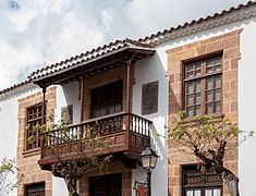
Teror is known for its architecturally diverse, mostly wooden balconies on the house fronts. The more splendid the balconies, the more affluent were the families who lived in them.

Basilica "Nuestra Señora del Pino"
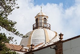
Dome of the "Nuestra Señora del Pino" basilica

City administration building

House facade, Calle Real de la Plaza

House facade, Calle Real de la Plaza
House facade, Calle Real de la Plaza

Balcony on Calle Real de la Plaza 15

Calle de la Diputación


Residents
The population of Teror increased by around 20% in the last decade of the previous and the first decade of this century. In 2011 it slowly began to fall again.
| year | Residents | Population density |
|---|---|---|
| 1991 | 10,368 | 403.4 inhabitants / km² |
| 1996 | 11,225 | 436.8 inhabitants / km² |
| 2000 | 11,898 | 463.0 inhabitants / km² |
| 2005 | 12,189 | 474.3 inhabitants / km² |
| 2010 | 12,944 | 503.7 inh / km² |
| 2011 | 12,932 | 503.2 inhabitants / km² |
| 2012 | 12,830 | 499.2 inhabitants / km² |
| 2013 | 12,761 | 496.5 inhabitants / km² |
| 2014 | 12,606 | 490.5 inhabitants / km² |
| 2015 | 12,499 | 486.3 inhabitants / km² |
Web links
- Teror Municipality website (Spanish)
Individual evidence
- ↑ Cifras oficiales de población resultantes de la revisión del Padrón municipal a 1 de enero . Population statistics from the Instituto Nacional de Estadística (population update).
- ↑ Spanish Statistics Authority (Instituto Nacional de Estadistica)
Agaete | Agüimes | Artenara | Arucas | Firgas | Gáldar | Ingenio | Mogán | Moya | Las Palmas | San Bartolomé de Tirajana | La Aldea de San Nicolás | Santa Brígida | Santa Lucía de Tirajana | Santa María de Guía | Tejeda | Telde | Teror | Valleseco | Valsequillo | Vega de San Mateo