Moya (Gran Canaria)
| Moya parish | ||
|---|---|---|
 View of Moya
|
||
| coat of arms | Map of the Canary Islands | |

|
|
|
| Basic data | ||
| Autonomous Community : | Canary Islands | |
| Province : | Las Palmas | |
| Island: | Gran Canaria | |
| Coordinates | 28 ° 7 ′ N , 15 ° 34 ′ W | |
| Height : | 490 msnm | |
| Area : | 31.87 km² | |
| Residents : | 7,696 (Jan 1, 2019) | |
| Population density : | 241.48 inhabitants / km² | |
| Postal code : | E-35420 | |
| Municipality number ( INE ): | 35013 | |
| administration | ||
| Mayor : | Antonio Perera Hernández ( CC ) (as of 09/2006) | |
| Address of the municipal administration: | C / Miguel Hernandez, 13 35420 - Moya |
|
| Website : | villademoya.es | |
| Location of the municipality | ||

|
||
Moya is a municipality on the Canary Island of Gran Canaria . It has 7696 inhabitants (as of January 1, 2019) on an area of 31.87 km².
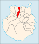
Moya is west of Las Palmas de Gran Canaria and north of Puerto Rico and GC2 . The neighboring municipalities are Arucas in the northwest, Firgas in the east, Valleseco in the southeast, Artenara and Tejeda in the south, and Gáldar in the southwest and Santa María de Guía de Gran Canaria in the west.
Residents
| year | Residents | Population density |
|---|---|---|
| 1991 | 8.007 | 251.2 inhabitants / km² |
| 1996 | 8,663 | 271.8 inhabitants / km² |
| 2001 | 8,137 | 255.3 inhabitants / km² |
| 2002 | 8,435 | 264.7 inhabitants / km² |
| 2003 | 8,307 | 260.7 inhabitants / km² |
| 2004 | 7,845 | 246.2 inhabitants / km² |
| 2005 | 7,801 | 244.8 inhabitants / km² |
economy
For centuries, the cheese made from sheep, goat or cow's milk from Moya and its neighboring communities Gáldar and Santa María de Guía has been known for its quality.
Web links
Commons : Moya - collection of images, videos and audio files
Individual evidence
- ↑ Cifras oficiales de población resultantes de la revisión del Padrón municipal a 1 de enero . Population statistics from the Instituto Nacional de Estadística (population update).
