
Santa María de Guía de Gran Canaria
| Municipality of Santa María de Guía de Gran Canaria | |||
|---|---|---|---|
| coat of arms | Map of the Canary Islands | ||
 Help on coat of arms |
|
||
| Basic data | |||
| Autonomous Community : | Canary Islands | ||
| Province : | Las Palmas | ||
| Island: | Gran Canaria | ||
| Coordinates | 28 ° 8 ′ N , 15 ° 35 ′ W | ||
| Height : | 180 msnm | ||
| Area : | 42.59 km² | ||
| Residents : | 13,850 (Jan 1, 2019) | ||
| Population density : | 325.19 inhabitants / km² | ||
| Postal code : | E-35450 | ||
| Municipality number ( INE ): | 35023 | ||
| administration | |||
| Mayor : | Pedro Manuel Rodríguez Pérez ( CC - PNC ) (as of 2010) | ||
| Address of the municipal administration: | C / Eusebia de Armas, 4 35450 - Santa María de Guía |
||
| Website : | www.santamariadeguia.es | ||
| Location of the municipality | |||

|
|||

Santa María de Guía de Gran Canaria is a municipality on the Canary Island of Gran Canaria . It has 13,850 inhabitants (as of January 1, 2019) on an area of 42.1 km².
Santa María de Guía is located in the north of Gran Canaria, west of Las Palmas . The neighboring communities are Moya in the east and Gáldar in the south and west.
Residents
| year | Residents | Population density |
|---|---|---|
| 1991 | 12,383 | 290.7 inhabitants / km² |
| 1996 | 13,117 | 308.0 inhabitants / km² |
| 2001 | 13,893 | 326.2 inhabitants / km² |
| 2002 | 14,171 | 332.7 inhabitants / km² |
| 2003 | 14,355 | 337.1 inhabitants / km² |
| 2004 | 14,107 | 331.2 inhabitants / km² |
| 2005 | 14,086 | 330.7 inhabitants / km |
| 2006 | 14,048 | 329.8 inhabitants / km |
| 2007 | 14,081 | 330.6 inhabitants / km |
| 2011 | 14.306 | 335.9 inhabitants / km |
| 2017 | 13,924 | 326.9 inhabitants / km |
history
The current city of Santa María de Guía was a district of Gáldar until 1526, where wealthy families settled. The sculptor José Luján Pérez (1756–1815) was born here in 1756 . A famous guest was the French composer Camille Saint-Saëns , who spent the winter in the city several times.
economy
The municipality of Santa María de Guía has fruit and vegetable plantations, but livestock is also raised. The dairy industry is important. A specialty of the region protected by the designation of origin " DOP " is the queso de flor , a cheese made from cow or sheep's milk, for the coagulation of which thistle blossoms are used, which gives it a typical bitter taste. Another important branch of the economy is handicrafts . The Cuchillos Canarios , the Canarian knives, are made in the city, which are characterized by particularly thin blades and inlaid handles.
Attractions
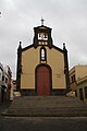
The city has a historical core that is one of the best preserved in Gran Canaria. It was therefore listed as a historical monument in 1982 . The oldest house is the Casa Quintana , built in the Canarian style in the 16th century . Opposite it is the late baroque parish church from the 18th century with neoclassical towers, in which some sculptures by José Luján Pérez can be found. Also noteworthy is the church of San Roque in the upper part of the old town.
In the area is the Cenobio de Valerón , an archaeological site of the Canarios (natives of Gran Canaria) . In a semicircular tufa quarry , they created a system of around 300 chambers dug into the stone, which they used as storage for grain and other essential goods.
gallery

Parish church

Casa de Quintana
San Roque

Cenobio de Valerón


Web links
- ISTAC (Statistical Department of the Regional Government of the Canary Islands)
- Santa María de Guía on www.kanaren-virtuell.de
Individual evidence
- ↑ Cifras oficiales de población resultantes de la revisión del Padrón municipal a 1 de enero . Population statistics from the Instituto Nacional de Estadística (population update).
- ↑ DOP Queso de Flor. In: descubreguia.com. Retrieved January 21, 2019 (Spanish).
- ↑ El Cenobio. In: cenobiodevaleron.com. Archived from the original on August 23, 2014 ; accessed on March 28, 2020 .
Agaete | Agüimes | Artenara | Arucas | Firgas | Gáldar | Ingenio | Mogán | Moya | Las Palmas | San Bartolomé de Tirajana | La Aldea de San Nicolás | Santa Brígida | Santa Lucía de Tirajana | Santa María de Guía | Tejeda | Telde | Teror | Valleseco | Valsequillo | Vega de San Mateo