
Itagi
| Itagi | |||
|---|---|---|---|
|
|||
| State : |
|
||
| State : | Karnataka | ||
| District : | Koppal | ||
| Sub-district : | Yelbarga | ||
| Location : | 15 ° 27 ' N , 75 ° 58' E | ||
| Height : | 590 m | ||
| Area : | 32.03 km² | ||
| Residents : | 4,180 (2011) | ||
| Population density : | 131 people / km² | ||
 |
|||

Itagi is a village with around 4,500 inhabitants in the Indian state of Karnataka . It is known for a Hindu temple from the beginning of the 12th century.
location
Itagi is located in the north of Karnataka on the Dekkan Plateau at an altitude of approx. 590 m above sea level. d. M .; the village is roughly halfway between the district capitals of Gadag in the west and Koppal in the east. The climate is subtropical and warm; Rain falls almost exclusively in the summer monsoon months .
population
Approx. 85% of the majority Kannada- speaking population are Hindus and about 14% are Muslim ; other religious groups hardly play a role in the rural regions of India. The male part of the population exceeds the female population by approx. 5%.
economy
The Itagi area is largely agricultural; Craftsmen, traders and service providers of all kinds have settled in the village.
history
In the early Middle Ages, the area around Gadag belonged to the rulership of the Chalukyas of Badami and the Rashtrakutas . In the 11th and 12th century, the town came under the sphere of influence of the Chalukyas of Kalyani until the Kalachuri and the Hoysala gradually took power, which the in 1348 Vijayanagar followed -Reich, itself in the 1565 battle of talikota the united armies of the Dekkan sultanates . However, these were divided among themselves and so the Hindu princely state of Mysore was able to take over power for a time, which was contested by the sultans of the Adil Shahi dynasty of Bijapur . From 1761 to 1799 Haidar Ali and Tipu Sultan , two more or less independently ruling generals of the princely state of Mysore, occupied power; thereafter the British influence grew stronger in South India.
Attractions

- The most important attraction of Itagi is the Mahadeva temple, dedicated to the Hindu god Shiva and completed in 1112. It consists of four merging parts: cella ( garbhagriha ), anteroom ( antarala or sukhanasi ), a closed anteroom ( mandapa or navaranga ) and a large open anteroom . The temple does not rest on a platform ( jagati ), so that the ritual circumnavigation ( pradakshina ) is only possible on the ground level covered with stone slabs. The outer walls of the building are richly structured and ornamented (niches with canopies etc.), but the lack of figures that may never have existed or were destroyed in Islamic times is striking . The cella is elevated by a horizontally stepped tower structure ( vimana ), the top was renewed later. The soapstone pillars of the vestibule are turned and carved; the ceiling segments are unadorned - only the segment in front of the entrance to the closed vestibule is covered with a cantilever dome with a hanging keystone . Immediately in front of the entrance is the lying Nandi figure, which is obligatory for a Shiva temple . In the cella there is a lingam made of black stone with a surrounding yoni .

Entrance portal to the closed vestibule

figural reliefs and kalasha jugs with overflowing foliage
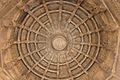
Cantilever dome with hanger
_in_the_Mahadeva_Temple_at_Itagi_in_the_Koppal_district.JPG)


- There are more shrines and a restored stepwell on the temple grounds .
Web links
- Itagi, Mahadeva Temple - Photos + Info (English)
- Itagi, Mahadeva Temple - Video
- Mahadeva Temple in Itagi (English)